Day Boulevard
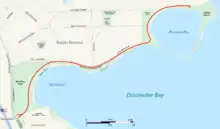
William J. Day Boulevard, or Day Boulevard, is a coastal parkway in Boston, Massachusetts. Beginning at Morrissey Boulevard and Kosciuszko Circle at the northern extent of the Dorchester section of the city, it travels in a gently curving northeasterly direction 2.6 miles (4.2 km) through South Boston along beaches around the west and north shore of Dorchester Bay. It was named for William J. Day.
 Map of South Boston with Day Boulevard highlighted in red | |
| Maintained by | Department of Conservation and Recreation |
|---|---|
| Length | 2.6 mi (4.2 km)[1] |
| Location | Boston, Middlesex County, Massachusetts |
| Coordinates | 42°19′51.18″N 71°01′50.38″W |
| West end | Morrissey Boulevard in South Boston |
| East end | Castle Island in South Boston |
In its eastern part, the road passes through the South Boston Boat Clubs Historic District and Marine Park before ending at Castle Island, site of a historic fort and state park.[2][3] It is owned and maintained by the Massachusetts Department of Conservation and Recreation as part of the Metropolitan Park System of Greater Boston. Carson Beach, M Street Beach and Pleasure Bay are beaches along Day Boulevard that are part of the park system.[3]
History
Day Boulevard was originally called the Strandway,[4] and was planned beginning in the late nineteenth century as the easternmost link of the Emerald Necklace, the string of connected parks and waterways created by Frederick Law Olmsted.[5][6] Plans for the connection of Franklin Park across Dorchester via a parkway to be called Dorchesterway to South Boston and Marine Park at the east end of the South Boston peninsula via the Strandway were not realized, and the route was eventually called Columbia Road.[7] The southern roadway of the two roadways that formed Columbia Road was named William J. Day Boulevard in honor of a popular South Boston political figure after he died in 1950.[8][9] William Day was the father of Louise Day Hicks, U.S. Representative for South Boston from 1971–73.[10]
Day Boulevard is listed on the National Register of Historic Places as part of the Old Harbor Reservation Parkways.
References
- Google (May 25, 2019). "Day Boulevard" (Map). Google Maps. Google. Retrieved May 25, 2019.
- Office of Geographic and Environmental Information (MassGIS), Commonwealth of Massachusetts Executive Office of Environmental Affairs - http://www.mass.gov/mgis/dd-over.htm
- "Castle Island, Pleasure Bay, M Street Beach and Carson Beach". Commonwealth of Massachusetts. Retrieved December 16, 2009.
- A record of the streets, alleys, places, etc. in the city of Boston. Boston City Council. 1910. p. 443.
- Address of Josiah Quincy, Mayor of Boston, to the City Council, January 4, 1897. Boston: Rockwell and Churchill. 1897. pp. 24–27. Retrieved December 16, 2009.
- Heart of the City Project, Center for Urban and Regional Policy, Harvard University and Northeastern University Archived 2011-05-24 at the Wayback Machine
- "John C. Phillips and others vs. the City of Boston". Massachusetts reports: cases argued and determined in the Supreme Judicial Court of Massachusetts. Vol. 209. Boston: Little, Brown, and Company. 1912. pp. 329–333. Retrieved December 16, 2009.
- Feeney, Mark (October 22, 2003). "Louise Day Hicks, icon of tumult, dies". The Boston Globe. Retrieved December 16, 2009.
- Reed, Christopher (October 29, 2003). "Obituary: Louise Day Hicks". The Guardian. London. Retrieved December 16, 2009.
- "Louise Day Hicks, Representative from Massachusetts". Washington, D.C.: United States House of Representatives. Archived from the original on March 11, 2016. Retrieved December 16, 2009.
