Yanranaygytgyn
Yanranaygytgyn (Russian: Янранайгытгын; Chukot: Янранайгытгын) is a freshwater lake in Iultinsky District, Chukotka Autonomous Okrug, Russian Federation.[1] It has an area of 10.6 km2 (4.1 sq mi) and a catchment area of 75.9 km2 (29.3 sq mi).[2]
| Yanranaygytgyn | |
|---|---|
| Янранайгытгын | |
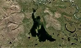 Sentinel-2 image of the lake in July | |
 Yanranaygytgyn Location in Chukotka Autonomous Okrug, Russian Far East | |
| Location | Chukotka Autonomous Okrug |
| Coordinates | 67°57′15″N 178°18′37″W |
| Type | Oligotrophic |
| Primary outflows | Unnamed |
| Catchment area | 75.9 km2 (29.3 sq mi) |
| Basin countries | Russia |
| Max. length | 6.2 km (3.9 mi) |
| Max. width | 2.6 km (1.6 mi) |
| Surface area | ca 10.6 km2 (4.1 sq mi) |
| Surface elevation | 304 m (997 ft) |
| Islands | 3 |
There are no permanent settlements on the shores of the lake.[1]
The name of the lake in Chukot means "a lake near a separate mountain."[3]
Geography
Yanranaygytgyn is located in the Chukotka Mountains, 35 km (22 mi) to the south of Ervynaygytgyn. The lake has a roughly triangular shape and there are three islands in the middle. The southern shore is indented and the lake narrows towards its northern end.[4]
Yanranaygytgyn lies in an area of lakes at the northern edge of the Amguema Valley. It is the largest of the cluster, together with lake Kontalyagytgyn that lies 5 km (3.1 mi) to the southwest. An unnamed river, a small tributary of the Amguema, flows out of the lake from the northern end. Yanranaygytgyn freezes in mid-September and stays under ice until June.[5]
Flora and fauna
Yanranaygytgyn is surrounded by tundra. Arctic char is common in the waters of the lake.[6]
See also
References
- Google Earth
- "Озеро Янранайгытгын in the State Water Register of Russia". textual.ru (in Russian).
- Leontiev V.V. & Novikova K.A. Toponymic Dictionary of the North-East of the USSR / scientific. ed. G. A. Menovschikov; FEB AN USSR . North-East complex. Research institutes. Lab archeology, history and ethnography. - Magadan: Magad. Prince Publishing House, 1989 . ISBN 5-7581-0044-7
- 1,000,000 scale Operational Navigation Chart; Sheet C-8
- Chukotka Autonomous Okrug - Water of Russia
- Travel and flyfishing in the Russian Far East