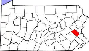
Lehigh County, Pennsylvania
Lehigh County (Pennsylvania Dutch: Lechaa Kaundi) is a county in the U.S. state of Pennsylvania. As of the 2020 census, the county's population was 374,557.[1] Its county seat is Allentown, the state's third largest city behind Philadelphia and Pittsburgh.[2]
Lehigh County | |
|---|---|
 Old Lehigh County Courthouse in Allentown, October 2011 | |
 Seal | |
 Location within the U.S. state of Pennsylvania | |
 Pennsylvania's location within the U.S. | |
| Coordinates: 40°37′N 75°35′W | |
| Country | |
| State | |
| Founded | March 6, 1812 |
| Named for | Lehigh River |
| Seat | Allentown |
| Largest city | Allentown |
| Area | |
| • Total | 348 sq mi (900 km2) |
| • Land | 345 sq mi (890 km2) |
| • Water | 3.1 sq mi (8 km2) 0.9%% |
| Population (2020) | |
| • Total | 374,557 |
| • Density | 1,046/sq mi (404/km2) |
| Time zone | UTC−5 (Eastern) |
| • Summer (DST) | UTC−4 (EDT) |
| Congressional district | 7th |
| Website | www |
Lehigh County and Northampton County to its east combine to form the Lehigh Valley region of eastern Pennsylvania. Lehigh County is one of the fastest-growing counties in Pennsylvania and the more highly populated of the two counties.[3][4] Both counties are part of the Philadelphia television market, the fourth largest television market in the nation.
The county is named for the Lehigh River, a 109-mile-long (175 km) tributary of the Delaware River, which flows through Lehigh County. The Lehigh River served a vital role in the county's development by offering a transportation and trading route for its mining products, including iron, manganese, and limestone, and ultimately for its manufacturing of steel products.
Lehigh County falls geographically between two Pennsylvania Appalachian mountain ranges, Blue Mountain to the county's north and South Mountain to its south. The county is located 61.6 miles (99.1 km) northwest of Philadelphia and 99.7 miles (160.5 km) west of New York City.
History


Settlement and founding
Lehigh County was first settled around 1730 and was formed in 1812 when Northampton County was divided into two counties. The county is named after the Lehigh River, a 109-mile-long (175 km) river that runs through the county and whose name is derived from the Lenape Indian term Lechauweki or Lechauwekink, meaning "where there are forks."[7] Shelter House, constructed in Emmaus in 1734 by Pennsylvania Dutch settlers, is the oldest continuously occupied structure in both Lehigh County and Lehigh Valley and among the oldest still-standing building structures in the U.S. state of Pennsylvania.[5][6]
American Revolutionary War
Some of the first resistance to British colonialism, which led ultimately to the American Revolutionary War, began in present day Lehigh County. On December 21, 1774, a Committee of Observation was formed by local American patriots. With the Declaration of Independence, the Colonial British government in Allentown began to break down and patriot militias took control, pressuring Tories out of the Allentown area, and plans were made for the raising of a patriot militia.
After Washington and the Continental Army were defeated at the Battle of Brandywine on September 11, 1777, the revolutionary capital of Philadelphia was left defenseless and Pennsylvania's Supreme Executive Council ordered that eleven Philadelphia bells, including the Liberty Bell (then known as the State House Bell), be taken down and moved to present day Allentown (then called Northamptontown) and hidden in the basement of Zion Reformed Church on present day West Hamilton Street to protect them from being melting down by the British Army for use as munitions. The Liberty Bell's successful protection in Allentown is commemorated in the Liberty Bell Museum, located in Zion Reformed Church in Allentown.
Industrial Revolution
The opening of the Lehigh Canal beginning in 1827 transformed Allentown and Lehigh County from a rural agricultural area dominated by German-speaking people into an urbanized industrialized area and expanded the city's commercial and industrial capacity greatly. With this, Lehigh County underwent significant industrialization, ultimately becoming a major 20th century center for heavy industry and manufacturing and one of several hubs for the Industrial Revolution.
American Civil War
Following the Union Army's defeat at the Battle of Fort Sumter and Lincoln's April 15, 1861 proclamation calling for state militia to provide 75,000 volunteer troops to defend the nation's capital of Washington, D.C., Allentown deployed the Allen Infantry, also known as the Allen Guards and composed of volunteers from Allentown and its surrounding suburbs. The unit mustered in for duty on April 18, 1861. As the Civil War progressed, multiple Union Army units were drawn from Lehigh County, including most of the 47th Pennsylvania Infantry Regiment. On October 19, 1899, a monument in honor of the Lehigh County men killed in their volunteer service to preservation of the Union, the Soldiers and Sailors Monument, was erected at Seventh and Hamilton Streets in Center City Allentown where it still stands.[8]
Geography


The U.S. Census Bureau reports that Lehigh County has a total area of 348 square miles (900 km2). Of this, 345 square miles (890 km2) is land and 3.1 square miles (8.0 km2) (0.9%) is water.[9]
Topography
Lehigh County is the most populous of the four counties (Carbon County in the Coal Region, Lehigh and Northampton counties in eastern Pennsylvania, and Warren County in northwestern New Jersey) that compose the Lehigh Valley metropolitan region.[10]
Lehigh County borders two Appalachian mountain ridges. To the north, the county borders Blue Mountain, which has an altitude of 1,300 to 1,604 feet (396 to 489 m). To the south, it is bordered by South Mountain, which has an altitude of 700 to 1,100 feet (210 to 340 m) and cuts through the southern portions of both Lehigh and Northampton counties. The Lehigh County's highest point is near Germansville at Bake Oven Knob, a mass of Tuscarora conglomeratic rocks that rise about 100 feet (30 m) above the main Blue Mountain ridge in northwestern Heidelberg Township.[11]
Lehigh County is part of the Delaware River watershed. Most of the county is drained by the Lehigh River and its tributaries, though the Schuylkill River also drains regions in the county's south through Perkiomen Creek and (in the county's northwest) through Maiden Creek.
Adjacent counties
- Berks County (west)
- Bucks County (southeast)
- Carbon County (north)
- Montgomery County (south)
- Northampton County (northeast)
- Schuylkill County (northwest)
Climate
Lehigh County's climate falls in the humid continental climate zone. The variety is hot-summer (Dfa) except in the county's higher elevation areas, where it is warm-summer (Dfb). Summers are typically hot and muggy, fall and spring are generally mild, and winter is cold. Precipitation is almost uniformly distributed throughout the year.
In Allentown, January lows average −6 °C (21 °F) and highs average 1.3 °C (34.3 °F). The lowest officially recorded temperature was −26.7 °C (−16.1 °F) in 1912. July lows average 17.6 °C (63.7 °F) and highs average 29.2 °C (84.6 °F) with an average relative humidity of 82%. The highest temperature on record was 40.6 °C (105.1 °F) in 1966. Early fall and mid-winter are generally driest with October being the driest month with only 74.7 mm of average precipitation.[12]
Snowfall is variable with some winters bringing light snow and others bringing numerous significant snowstorms. Average snowfall is 82.3 centimetres (32.4 in) per year,[13] with the months of January and February receiving the most now with just over 22.86 centimetres (9.00 in) in each of these months. Rainfall is generally spread throughout the year with eight to twelve wet days per month,[14] at an average annual rate of 110.54 centimetres (43.52 in).[15]
| Climate data for Allentown, Pennsylvania (Lehigh Valley International Airport) 1991-2020 normals (Records x-2021) | |||||||||||||
|---|---|---|---|---|---|---|---|---|---|---|---|---|---|
| Month | Jan | Feb | Mar | Apr | May | Jun | Jul | Aug | Sep | Oct | Nov | Dec | Year |
| Record high °F (°C) | 72 (22) |
81 (27) |
87 (31) |
93 (34) |
97 (36) |
100 (38) |
105 (41) |
100 (38) |
99 (37) |
93 (34) |
81 (27) |
72 (22) |
105 (41) |
| Average high °F (°C) | 38.4 (3.6) |
41.6 (5.3) |
50.8 (10.4) |
63.4 (17.4) |
73.5 (23.1) |
81.9 (27.7) |
86.4 (30.2) |
84.3 (29.1) |
77.4 (25.2) |
65.5 (18.6) |
53.8 (12.1) |
43.1 (6.2) |
63.3 (17.4) |
| Daily mean °F (°C) | 30.1 (−1.1) |
32.4 (0.2) |
40.7 (4.8) |
51.8 (11.0) |
62.0 (16.7) |
70.9 (21.6) |
75.6 (24.2) |
73.6 (23.1) |
66.3 (19.1) |
54.6 (12.6) |
43.9 (6.6) |
35.0 (1.7) |
53.1 (11.7) |
| Average low °F (°C) | 21.8 (−5.7) |
23.2 (−4.9) |
30.5 (−0.8) |
40.3 (4.6) |
50.6 (10.3) |
59.9 (15.5) |
64.7 (18.2) |
62.8 (17.1) |
55.2 (12.9) |
43.8 (6.6) |
34.1 (1.2) |
26.8 (−2.9) |
42.8 (6.0) |
| Record low °F (°C) | −15 (−26) |
−12 (−24) |
−5 (−21) |
12 (−11) |
28 (−2) |
39 (4) |
46 (8) |
41 (5) |
30 (−1) |
21 (−6) |
3 (−16) |
−8 (−22) |
−15 (−26) |
| Average precipitation inches (mm) | 3.30 (84) |
2.77 (70) |
3.63 (92) |
3.67 (93) |
3.65 (93) |
4.40 (112) |
5.30 (135) |
4.56 (116) |
4.84 (123) |
4.14 (105) |
3.24 (82) |
3.86 (98) |
47.36 (1,203) |
| Average snowfall inches (cm) | 9.8 (25) |
10.8 (27) |
6.3 (16) |
0.5 (1.3) |
0.0 (0.0) |
0.0 (0.0) |
0.0 (0.0) |
0.0 (0.0) |
0.0 (0.0) |
0.2 (0.51) |
0.9 (2.3) |
4.6 (12) |
33.1 (84) |
| Average precipitation days (≥ 0.01 in) | 11 | 10 | 11 | 12 | 12 | 11 | 11 | 10 | 10 | 10 | 9 | 12 | 129 |
| Average snowy days (≥ 0.1 in) | 5 | 4 | 3 | 0 | 0 | 0 | 0 | 0 | 0 | 0 | 1 | 3 | 16 |
| Source: NOAA[16] | |||||||||||||
Demographics
| Historical population | |||
|---|---|---|---|
| Census | Pop. | %± | |
| 1820 | 18,895 | — | |
| 1830 | 22,256 | 17.8% | |
| 1840 | 25,787 | 15.9% | |
| 1850 | 32,479 | 26.0% | |
| 1860 | 43,753 | 34.7% | |
| 1870 | 56,796 | 29.8% | |
| 1880 | 65,969 | 16.2% | |
| 1890 | 76,631 | 16.2% | |
| 1900 | 93,893 | 22.5% | |
| 1910 | 118,832 | 26.6% | |
| 1920 | 148,101 | 24.6% | |
| 1930 | 172,893 | 16.7% | |
| 1940 | 177,533 | 2.7% | |
| 1950 | 198,207 | 11.6% | |
| 1960 | 227,536 | 14.8% | |
| 1970 | 255,304 | 12.2% | |
| 1980 | 272,349 | 6.7% | |
| 1990 | 291,130 | 6.9% | |
| 2000 | 312,090 | 7.2% | |
| 2010 | 349,497 | 12.0% | |
| 2020 | 374,557 | 7.2% | |
| U.S. Decennial Census[17] 1790-1960[18] 1900-1990[19] 1990-2000[20] 2010-2019[21] | |||
As of the 2020 census, the county's population was 374,557.[1] The county's population growth of 7.2% since 2010 is among the fastest in the state.[22]
As of the 2010 census,[23] there were 312,090 people, 121,906 households, and 82,164 families residing in the county. The population density was 900 people per square mile (348/km2). There were 128,910 housing units at an average density of 372 per square mile (144/km2). The racial makeup of the county was 87.02% White, 3.56% Black or African American, 0.18% Native American, 2.10% Asian, 0.04% Pacific Islander, 5.28% from other races, and 1.83% from two or more races. 10.22% of the population were Hispanic or Latino of any race. 27.1% were of German, 7.9% Italian, 7.7% Irish, 6.2% Pennsylvania Dutch, and 5.6% American ancestry. 85.0% spoke English, 8.4% Spanish and 1.2% Arabic as their first language.
There were 121,906 households, out of which 30.60% had children under the age of 18 living with them, 53.00% were married couples living together, 10.50% had a female householder with no husband present, and 32.60% were non-families. 27.10% of all households were made up of individuals, and 11.20% had someone living alone who was 65 years of age or older. The average household size was 2.48 and the average family size was 3.02.
Lehigh County's population is spread out with 23.90% under the age of 18, 8.10% from 18 to 24, 29.20% from 25 to 44, 23.00% from 45 to 64, and 15.80% who were 65 years of age or older. The median age was 38 years. For every 100 females there were 93.20 males. For every 100 females age 18 and over, there were 89.60 males.
2020 Census
| Race | Num. | Perc. |
|---|---|---|
| White (NH) | 227,994 | 60.8% |
| Black or African American (NH) | 22,950 | 6.12% |
| Native American (NH) | 337 | 0.1% |
| Asian (NH) | 13,725 | 3.66% |
| Pacific Islander (NH) | 91 | 0.02% |
| Other/Mixed (NH) | 12,479 | 3.33% |
| Hispanic or Latino | 96,981 | 26% |
Politics and government
As of September 2022, there were 236,122 registered voters in Lehigh County:[25]
- Democratic: 110,967 (46.99%)
- Republican: 82,093 (34.77%)
- No affiliation: 35,271 (14.94%)
- Other parties: 7,791 (3.30%)
Lehigh County and neighboring Northampton County are part of Pennsylvania's 7th Congressional district. The 7th Congressional district is a contentious swing district with neither Republicans nor Democrats winning the district consistently. Voters elected Republican Charlie Dent in 2004, 2006, and 2008 and, previously, Republican Pat Toomey in 1998, 2000, and 2002. In 2004, the county narrowly voted for John Kerry over George W. Bush for President. In 2008, all statewide Democratic candidates won the county with significant leads and, in the presidential election, Barack Obama won the county, 57.1% to 41.5%, over John McCain. In the 2012 presidential election, Obama again carried the county but by a narrower margin, 53.17% to 45.52%.[26]
| Year | Republican | Democratic | Third party | |||
|---|---|---|---|---|---|---|
| No. | % | No. | % | No. | % | |
| 2020 | 84,418 | 45.47% | 98,498 | 53.05% | 2,739 | 1.48% |
| 2016 | 73,690 | 45.28% | 81,324 | 49.97% | 7,719 | 4.74% |
| 2012 | 66,874 | 45.42% | 78,283 | 53.17% | 2,067 | 1.40% |
| 2008 | 63,382 | 41.57% | 87,089 | 57.12% | 2,002 | 1.31% |
| 2004 | 70,160 | 48.36% | 73,940 | 50.96% | 991 | 0.68% |
| 2000 | 55,492 | 47.71% | 56,667 | 48.72% | 4,148 | 3.57% |
| 1996 | 45,103 | 42.51% | 48,568 | 45.77% | 12,439 | 11.72% |
| 1992 | 42,631 | 37.12% | 46,711 | 40.68% | 25,494 | 22.20% |
| 1988 | 56,363 | 56.30% | 42,801 | 42.76% | 943 | 0.94% |
| 1984 | 61,799 | 59.69% | 41,089 | 39.69% | 649 | 0.63% |
| 1980 | 50,782 | 52.91% | 34,827 | 36.28% | 10,376 | 10.81% |
| 1976 | 46,895 | 49.20% | 46,620 | 48.92% | 1,793 | 1.88% |
| 1972 | 58,023 | 62.39% | 33,325 | 35.83% | 1,654 | 1.78% |
| 1968 | 47,255 | 49.53% | 44,033 | 46.15% | 4,120 | 4.32% |
| 1964 | 32,245 | 34.64% | 60,377 | 64.86% | 471 | 0.51% |
| 1960 | 54,278 | 57.64% | 39,640 | 42.10% | 249 | 0.26% |
| 1956 | 50,564 | 63.30% | 29,067 | 36.39% | 251 | 0.31% |
| 1952 | 45,143 | 57.52% | 33,033 | 42.09% | 303 | 0.39% |
| 1948 | 32,202 | 53.65% | 26,826 | 44.69% | 994 | 1.66% |
| 1944 | 31,584 | 51.75% | 29,134 | 47.73% | 315 | 0.52% |
| 1940 | 29,584 | 47.00% | 33,007 | 52.43% | 359 | 0.57% |
| 1936 | 25,841 | 41.27% | 35,325 | 56.41% | 1,455 | 2.32% |
| 1932 | 21,169 | 46.95% | 21,939 | 48.65% | 1,985 | 4.40% |
| 1928 | 40,291 | 74.35% | 13,463 | 24.84% | 434 | 0.80% |
| 1924 | 20,826 | 59.02% | 10,415 | 29.52% | 4,043 | 11.46% |
| 1920 | 18,032 | 59.49% | 10,863 | 35.84% | 1,415 | 4.67% |
| 1916 | 10,588 | 44.67% | 11,920 | 50.29% | 1,194 | 5.04% |
| 1912 | 2,722 | 12.20% | 10,834 | 48.56% | 8,755 | 39.24% |
| 1908 | 11,593 | 48.80% | 11,285 | 47.50% | 879 | 3.70% |
| 1904 | 11,826 | 52.89% | 10,138 | 45.34% | 394 | 1.76% |
| 1900 | 9,775 | 47.64% | 10,438 | 50.87% | 304 | 1.48% |
| 1896 | 9,507 | 48.90% | 9,369 | 48.19% | 567 | 2.92% |
| 1892 | 7,089 | 41.65% | 9,699 | 56.99% | 231 | 1.36% |
| 1888 | 6,977 | 43.35% | 8,927 | 55.47% | 190 | 1.18% |
| 1884 | 6,357 | 43.72% | 8,095 | 55.67% | 88 | 0.61% |
| 1880 | 6,144 | 42.49% | 8,292 | 57.35% | 23 | 0.16% |
County executives
| Name | Party | Term start | Term end |
|---|---|---|---|
| Jane R. Ervin | Republican | 2002 | 2006 |
| Don Cunningham | Democratic | 2006 | 2012 |
| William H. Hansell, Jr. | Democratic | 2012 | 2013 |
| Matt Croslis | Democratic | 2013 | 2014 |
| Tom Muller | Democratic | 2014 | 2018 |
| Phil Armstrong | Democratic | 2018 | Incumbent |
Commissioners
| District | Holder | Party |
|---|---|---|
| 1st | Antonio Pineda | Republican |
| 2nd | Ron Beitler | Republican |
| 3rd | Zach Cole Borghi | Democratic |
| 4th | Geoff Brace | Democratic |
| 5th | Jeffrey Dutt | Republican |
| At-Large | Bob Elbich | Democratic |
| At-Large | Dave Harrington | Democratic |
| At-Large | Dan Hartzell | Democratic |
| At-Large | Zakiya Smalls | Democratic |
Other county offices
| Office | Holder | Party |
|---|---|---|
| Clerk of Judicial Records | Andrea Naugle | Democratic |
| County Executive | Phil Armstrong | Democratic |
| Controller | Mark Pinsley | Democratic |
| Coroner | Daniel A. Buglio | Democratic |
| District Attorney | James B. Martin | Republican |
| Sheriff | Joseph Hanna | Republican |
State House of Representatives[28]
| District | Representative | Party |
|---|---|---|
| 22 | Peter Schweyer | Democratic |
| 131 | Milou Mackenzie | Republican |
| 132 | Michael H. Schlossberg | Democratic |
| 133 | Jeanne McNeill | Democratic |
| 134 | Ryan E. Mackenzie | Republican |
| 183 | Zach Mako | Republican |
| 187 | Gary Day | Republican |
State Senate[28]
| District | Representative | Party |
|---|---|---|
| 16 | Pat Browne | Republican |
| 18 | Lisa Boscola | Democratic |
U.S. House of Representatives
- Susan Wild, Democrat, Pennsylvania's 7th congressional district
Education

.JPG.webp)


4-year colleges and universities
- Cedar Crest College, Allentown
- DeSales University, Center Valley
- Muhlenberg College, Allentown
- Penn State Lehigh Valley, Center Valley
2-year colleges and technical institutes
- Baum School of Art, Allentown
- Lehigh Carbon Community College, Schnecksville (main campus), and Donley Center, Allentown (satellite campus)
- Lincoln Tech, Allentown
Public school districts
- Allentown School District
- William Allen High School, Allentown
- Louis E. Dieruff High School, Allentown
- Francis D. Raub Middle School, Allentown
- Harrison-Morton Middle School, Allentown
- South Mountain Middle School, Allentown
- Trexler Middle School, Allentown
- Catasauqua Area School District
- Catasauqua High School, Northampton
- Catasauqua Middle School, Catasauqua
- East Penn School District
- Emmaus High School, Emmaus
- Eyer Middle School, Macungie
- Lower Macungie Middle School, Macungie
- Northern Lehigh School District
- Northern Lehigh High School, Slatington
- Northern Lehigh Middle School, Slatington
- Northwestern Lehigh School District
- Northwestern Lehigh High School, New Tripoli
- Northwestern Lehigh Middle School, New Tripoli
- Parkland School District
- Parkland High School, South Whitehall Township
- Orefield Middle School, Orefield
- Springhouse Middle School, Allentown
- Salisbury Township School District
- Salisbury High School, Salisbury Township
- Salisbury Middle School, Allentown
- Southern Lehigh School District
- Southern Lehigh High School, Center Valley
- Southern Lehigh Middle School, Center Valley
- Whitehall-Coplay School District
- Whitehall High School, Whitehall Township
- Whitehall-Coplay Middle School, Whitehall Township
Public charter schools
- Lincoln Leadership Academy Charter School, Allentown
- Roberto Clemente Charter School, Allentown
- Seven Generations Charter School, Emmaus
Private high schools
- Allentown Central Catholic High School, Allentown
- Salem Christian School, Macungie
Vocational high school
- Lehigh Career and Technical Institute, Schnecksville
Transportation and infrastructure
.JPG.webp)

Air
Lehigh County's primary commercial airport is Lehigh Valley International Airport (IATA: ABE, ICAO: KABE), located in Hanover Township. The county is also served by Allentown Queen City Municipal Airport, a two-runway general aviation facility located off Lehigh Street in Allentown and used predominantly by private aviation.[29]
Bus
Public bus service in Lehigh County is available through the Lehigh and Northampton Transportation Authority, known as LANTA. Several private bus lines, including Fullington Trailways and Trans-Bridge Lines, provide bus service from Allentown to New York City's Port Authority Bus Terminal, Philadelphia's Greyhound Terminal and 30th Street Station, Atlantic City's Bus Terminal, and other regional locations.
Major highways
 I-78
I-78
 I-476 / Penna Turnpike NE Extension
 US 22
US 22 US 222
 PA 29
PA 29 PA 100
 PA 143
 PA 145
 PA 222
 PA 309
 PA 329
 PA 378
 PA 863
 PA 873
 PA 987
- Cedar Crest Boulevard
- Lehigh Street
- Tilghman Street
Media

Newspapers
The Morning Call (in Allentown), The Express-Times (in Easton), and The Times News (in Lehighton) each cover Lehigh County.
Radio
Lehigh County-area radio stations include WAEB-AM in Allentown (talk and news), B104 in Allentown (contemporary hits), WZZO in Bethlehem (classic rock), WHOL in Allentown (rhythmic contemporary), and others. Some major New York City stations and every major Philadelphia station are received in the county.
Television
Lehigh County is part of the Philadelphia broadcast media market, the nation's fourth largest media market. Numerous New York City radio and television stations are also carried in the county. Three television stations are based in the county, WBPH-TV Channel 60, WLVT Channel 39 (the Lehigh Valley's PBS affiliate), and WFMZ Channel 69 (an independent television station).
The four major Philadelphia-based network stations serving Lehigh County are KYW-TV (the CBS affiliate), WCAU (the NBC affiliate), WPVI (the ABC affiliate), and WTXF (the Fox affiliate). The four major New York City-based network stations serving Lehigh County are WABC (the ABC affiliate), WCBS-TV (the CBS affiliate), WNBC (the NBC affiliate), and WNYW (the Fox affiliate). The four major Scranton-Wilkes-Barre-based network stations serving Lehigh County are WNEP-TV (the ABC affiliate), WBRE-TV (the NBC affiliate), WYOU (the CBS affiliate), and WOLF-TV (the Fox affiliate).
Telecommunications
From 1947 until 1994, Lehigh County was served exclusively by the 215 area code. With the county's growing population, area code 610 was also allocated to the county in 1994. Today, Lehigh County is covered largely by the 610 area code. An overlay area code, 484, was added to the 610 service area in 1999.[30] A plan to introduce area code 835 as an additional overlay was rescinded in 2001. It has since been reintroduced and will begin use once 610 and 484 extensions are exhausted, possibly as early as September 2022.[31]
Recreation


Amusement parks
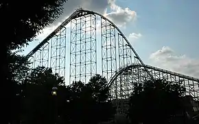
Dorney Park & Wildwater Kingdom, one of the largest amusement and water parks on the U.S. East Coast, is located in South Whitehall Township in the county. It is open May through the end of October.
Fairs and festivals
The Great Allentown Fair, one of the nation's largest and longest ongoing city fairs, is held annually at Allentown Fairgrounds on North 17th Street in Allentown the end of August and beginning of September. Mayfair, an arts and festival fair, is held annually in May on the campus of Cedar Crest College in Allentown.
Golf
Lehigh County is home to multiple golf courses, including Brookside Country Club in Macungie, Lehigh Country Club on Cedar Crest Boulevard in Allentown, Olde Homestead Golf Club in New Tripoli, Saucon Valley Country Club in Upper Saucon Township, Shepherd Hills Golf Club in Wescosville, and Wedgewood Golf Course in Coopersburg.
Museums and history
The county has several museums, including Allentown Art Museum, America on Wheels, Da Vinci Science Center, George Taylor House, Jacob Ehrenhardt Jr. House, Lehigh County Historical Society at Trout Hall, Liberty Bell Museum, Museum of Indian Culture, and others.
Parks and zoo
Lehigh Valley Zoo is located in Schnecksville in the county and is open year-round. Lehigh County also has 25 acres (100,000 m2) of public parks, including:
- Lehigh Parkway in Allentown, a 999 acres (4.04 km2) city-owned park along Little Lehigh Creek.
- Lock Ridge Park in Alburtis, a 59.2 acres (0.240 km2) county-owned park along Swabia Creek that includes the Lock Ridge Furnace Museum.
- Trexler Nature Preserve in North Whitehall Township, a 1,108 acres (4.48 km2) county-owned park along Jordan Creek, which includes the Lehigh Valley Zoo.
- Whitehall Parkway in Whitehall Township, a 110 acres (0.45 km2) township-owned park connected to the 9 miles (14 km) Ironton Rail Trail.
Communities


Under Pennsylvania law, there are four types of incorporated municipalities: cities, boroughs, townships, and, in only one case, towns. The following cities, boroughs, and townships are located in Lehigh County:
Boroughs
- Alburtis
- Catasauqua
- Coopersburg
- Coplay
- Emmaus
- Fountain Hill
- Macungie
- Slatington
Townships
- Hanover Township
- Heidelberg Township
- Lower Macungie Township
- Lower Milford Township
- Lowhill Township
- Lynn Township
- North Whitehall Township
- Salisbury Township
- South Whitehall Township
- Upper Macungie Township
- Upper Milford Township
- Upper Saucon Township
- Washington Township
- Weisenberg Township
- Whitehall Township
Census-designated places
Census-designated places are geographical areas designated by the U.S. Census Bureau for the purposes of compiling demographic data. They are not actual jurisdictions under Pennsylvania law. Other unincorporated communities, such as villages, may be listed here as well.
- Ancient Oaks
- Breinigsville
- Cementon
- Cetronia
- DeSales University
- Dorneyville
- Egypt
- Fullerton
- Hokendauqua
- Laurys Station
- New Tripoli
- Schnecksville
- Slatedale
- Stiles
- Trexlertown
- Wescosville
Unincorporated communities
- Balliettsville
- Best Station
- Center Valley
- Colesville
- Eagle Point
- East Texas
- Emerald
- Fogelsville
- Friedensville
- Gauff Hill
- Germansville
- Hensingersville
- Hosensack
- Ironton
- Jacksonville
- Kuhnsville
- Lanark
- Limeport
- Locust Valley
- Lynnport
- Mickleys
- Neffs
- New Smithville
- Old Zionsville
- Orefield
- Pleasant Corners
- Powder Valley
- Scherersville
- Schoenersville
- Shimerville
- Sigmund
- Summit Lawn
- Vera Cruz
- Walbert
- Wanamakers
- Werleys Corner
- West Catasauqua
- Zionsville
Population ranking
Lehigh County's largest cities, townships, boroughs, and other communities, based on the 2020 census, include:[33]
† county seat
| Rank | City/Town/etc. | Municipal type | Population (2020 Census) |
|---|---|---|---|
| 1 | † Allentown | City | 125,845 |
| 2 | Bethlehem (mostly in Northampton County) | City | 74,982 |
| 4 | Emmaus | Borough | 11,652 |
| 5 | Ancient Oaks | CDP | 6,995 |
| 6 | Catasauqua | Borough | 6,518 |
| 7 | Wescosville | CDP | 6,039 |
| 8 | Fountain Hill | Borough | 4,878 |
| 9 | Dorneyville | CDP | 4,406 |
| 10 | Slatington | Borough | 4,232 |
| 11 | Breinigsville | CDP | 4,138 |
| 13 | Coplay | Borough | 3,192 |
| 14 | Macungie | Borough | 3,074 |
| 15 | Schnecksville | CDP | 2,935 |
| 17 | Coopersburg | Borough | 2,386 |
| 18 | Alburtis | Borough | 2,361 |
| 19 | Cetronia | CDP | 2,115 |
| 20 | Trexlertown | CDP | 1,988 |
| 22 | Laurys Station | CDP | 1,243 |
| 24 | DeSales University | CDP | 953 |
| 25 | New Tripoli | CDP | 898 |
| 26 | Slatedale | CDP | 455 |
Notable people
Since its founding in 1812, Lehigh County has been the birthplace or home to several notable Americans, including:
- Chuck Bednarik, former professional football player, Philadelphia Eagles, and 1967 Pro Football Hall of Fame inductee
- Stephen Vincent Benét, former novelist
- Michaela Conlin, stage and television actress, Bones
- Lee Iacocca, former president and chief executive officer of Chrysler
- Keith Jarrett, jazz musician
- Michael Johns, healthcare executive and former White House presidential speechwriter
- Billy Kidman, former professional wrestler
- Carson Kressley, Emmy-winning fashion designer, Bravo's Queer Eye
- Rose Lambert, former American missionary and witness of the 1909 Adana massacre of Armenians
- Varvara Lepchenko, professional tennis player
- Lil Peep, former American emo rapper, singer, and songwriter
- Matt Millen, former professional football player, Oakland Raiders, San Francisco 49ers, and Washington Redskins, and former president and general manager, Detroit Lions
- Andre Reed, former professional football player, Buffalo Bills and Washington Redskins, and 2014 Pro Football Hall of Fame inductee
- Amanda Seyfried, actress, Veronica Mars, Big Love, Mamma Mia!, and Les Misérables
- Curt Simmons, former professional baseball player, California Angels, Chicago Cubs, Philadelphia Phillies, and St. Louis Cardinals
- Eric Steckel, blues singer, guitarist, songwriter, and record producer
- Dana Snyder, film and television actor, Aqua Teen Hunger Force
- Christine Taylor, actress and wife of actor Ben Stiller
- Lauren Weisberger, author of The Devil Wears Prada
References
- Lehigh County at U.S. Census Quick Facts
- "Find a County". National Association of Counties. Retrieved June 7, 2011.
- "The Lehigh Valley is growing, census numbers show," Lehigh Valley Live, August 23, 2021
- Kraus, Scott (April 2, 2016). "Migration driving Lehigh Valley's recent population growth". The Morning Call. Retrieved May 17, 2017.
- Shelter House official website, retrieved May 4, 2022
- "Emmaus" at Lehigh Valley Marketplace
- Roberts, Charles R. (1936). "Place Names of Lehigh County and Their Origin". Proceedings: Lehigh County Historical Society. Lehigh County Historical Society.
- Farris, Jaccii. "Eagles to be returned to the top of Soldiers and Sailors Monument in Allentown". Wfmz.com. Retrieved September 11, 2022.
- "2010 Census Gazetteer Files". United States Census Bureau. August 22, 2012. Retrieved March 9, 2015.
- "Metropolitan statistical areas and components". Census.gov. Retrieved December 19, 2009.
- Miller, Benjamin LeRoy (1941). Lehigh County Pennsylvania: Geology and Geography. Harrisburg, Pennsylvania: Department of Internal Affairs, Commonwealth of Pennsylvania.
- "Normal Monthly Precipitation, Inches". Archived from the original on September 19, 2006. Retrieved November 4, 2006.
- "Snowfall – Average Total In Inches". Archived from the original on June 19, 2011. Retrieved November 4, 2006.
- "Average Days of Precipitation, .01 cm or more". Archived from the original on November 3, 2006. Retrieved November 4, 2006.
- "Average Monthly Precipitation". Archived from the original on September 19, 2006. Retrieved November 4, 2006.
- "NowData - NOAA Online Weather Data". National Oceanic and Atmospheric Administration. Retrieved May 11, 2021.
- "U.S. Decennial Census". United States Census Bureau. Retrieved March 9, 2015.
- "Historical Census Browser". University of Virginia Library. Retrieved March 9, 2015.
- Forstall, Richard L., ed. (March 24, 1995). "Population of Counties by Decennial Census: 1900 to 1990". United States Census Bureau. Retrieved March 9, 2015.
- "Census 2000 PHC-T-4. Ranking Tables for Counties: 1990 and 2000" (PDF). United States Census Bureau. April 2, 2001. Archived (PDF) from the original on October 9, 2022. Retrieved March 9, 2015.
- "State & County QuickFacts". United States Census Bureau. Archived from the original on June 6, 2011. Retrieved November 17, 2013.
- "The Lehigh Valley is growing, census numbers show" Lehigh Valley Live, August 23, 2021
- "U.S. Census website". United States Census Bureau. Retrieved January 31, 2008.
- "P2 HISPANIC OR LATINO, AND NOT HISPANIC OR LATINO BY RACE – 2020: DEC Redistricting Data (PL 94-171) – Lehigh County, Pennsylvania".
- "Commonwealth of Pennsylvania 2021 Voter Registration Statistics - Official Primary Voting Analysis" (PDF). Dos.pa.gov. May 18, 2021. Archived (PDF) from the original on October 9, 2022. Retrieved September 11, 2022.
- "Election Results 2008: President Map". New York Times. November 21, 2008. Retrieved November 23, 2008.
- Leip, David. "Dave Leip's Atlas of U.S. Presidential Elections". uselectionatlas.org.
- "Find Your Legislator". The official website for the Pennsylvania General Assembly. Legislativate Data Processing Center. Retrieved April 21, 2017.
- "Queen City Airport Designated General Aviation Airport of the Year by the Federal Administration Eastern Region". Lehigh Valley International Airport. Archived from the original on June 12, 2007. Retrieved June 22, 2007.
- "NANP-Overlay of 610 (Pennsylvania) Numbering Plan Area (NPA) with 484 NPA". Nanpa.com. (359 KB)
- "PUC reminds eastern and southern pa residents of uocoming activation of '835' area code". www.puc.pa.gov. (20.8 KB)
- "Rollercoaster Database: Steel Force (Dorney Park & Wildwater Kingdom)website=Rcdb.com". Retrieved July 10, 2008.
- "2010 U.S. Census website". United States Census Bureau. Retrieved July 10, 2016.
External links
- Official website
- Lehigh County news at The Morning Call
- Lehigh County news at Lehigh Valley Live
- "Famous People from the Lehigh Valley," The Baltimore Sun, August 9, 2005
Places adjacent to Lehigh County, Pennsylvania | ||||||||||||||||
|---|---|---|---|---|---|---|---|---|---|---|---|---|---|---|---|---|
| ||||||||||||||||
Municipalities and communities of Lehigh County, Pennsylvania, United States | ||
|---|---|---|
County seat: Allentown | ||
| Region |
| |
| Cities | ||
| Boroughs |
| |
| Townships |
| |
| CDPs |
| |
| Unincorporated communities |
| |
| Notable people |
| |
| Culture |
| |
| Footnotes | ‡This populated place also has portions in an adjacent county or counties | |
| ||
| |
Commonwealth of Pennsylvania | |
|---|---|
Harrisburg (capital) | |
| Topics |
|
| Society |
|
| Metro areas |
|
| Largest cities |
|
| Largest municipalities |
|
| Regions |
|
| Counties |
|