Číčenice
Číčenice is a municipality and village in Strakonice District in the South Bohemian Region of the Czech Republic. It has about 500 inhabitants.
Číčenice | |
|---|---|
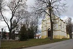 Church of Saint Wenceslaus in the centre | |
 Flag  Coat of arms | |
 Číčenice Location in the Czech Republic | |
| Coordinates: 49°9′11″N 14°13′51″E | |
| Country | |
| Region | South Bohemian |
| District | Strakonice |
| First mentioned | 1335 |
| Area | |
| • Total | 11.95 km2 (4.61 sq mi) |
| Elevation | 404 m (1,325 ft) |
| Population (2023-01-01)[1] | |
| • Total | 472 |
| • Density | 39/km2 (100/sq mi) |
| Time zone | UTC+1 (CET) |
| • Summer (DST) | UTC+2 (CEST) |
| Postal code | 389 01 |
| Website | www |
Administrative parts
%252C_statek.jpg.webp)

Villages of Strpí and Újezdec are administrative parts of Číčenice.
Geography
Číčenice is located about 26 kilometres (16 mi) southeast of Strakonice and 26 km (16 mi) northwest of České Budějovice. It lies in the České Budějovice Basin. The highest point is a flat hill at 449 m (1,473 ft) above sea level. There are several ponds in the territory.
History
The first written mention of Číčenice is from 1335.[2]
Transport
The Číčenice railway station is an important junction of the railways České Budějovice – Plzeň and Týn nad Vltavou – Volary. There is also Újezdec u Číčenic railway station of local importance.
Sights
The landmark of Číčenice is the Church of Saint Wenceslaus, a neo-Gothic church from 1888.[3]
References
- "Population of Municipalities – 1 January 2023". Czech Statistical Office. 2023-05-23.
- "Obec Číčenice" (in Czech). Obec Číčenice. Retrieved 2021-08-23.
- "Kostel sv. Václava" (in Czech). Vodňany Town Museum and Gallery. Retrieved 2022-08-28.