Přechovice
Přechovice is a municipality and village in Strakonice District in the South Bohemian Region of the Czech Republic. It has about 100 inhabitants.
Přechovice | |
|---|---|
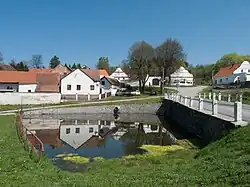 Centre of Přechovice | |
 Flag  Coat of arms | |
 Přechovice Location in the Czech Republic | |
| Coordinates: 49°10′47″N 13°53′41″E | |
| Country | |
| Region | South Bohemian |
| District | Strakonice |
| First mentioned | 1400 |
| Area | |
| • Total | 3.96 km2 (1.53 sq mi) |
| Elevation | 445 m (1,460 ft) |
| Population (2023-01-01)[1] | |
| • Total | 142 |
| • Density | 36/km2 (93/sq mi) |
| Time zone | UTC+1 (CET) |
| • Summer (DST) | UTC+2 (CEST) |
| Postal code | 387 01 |
| Website | www |
Geography
Přechovice is located about 9 kilometres (6 mi) south of Strakonice and 47 km (29 mi) northwest of České Budějovice. It lies in the Bohemian Forest Foothills. The highest point is the hill Manina at 640 m (2,100 ft) above sea level. The municipality is situated on the right bank of the Volyňka River.
Transport
Přechovice is located on a railway line leading from Strakonice to Volary. The train stop in Přechovice is named Hoštice u Volyně after the neighbouring municipality.
Sights
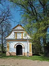
The main landmark of Přechovice is the Chapel of Saint Anne Chapel. It was built in 1836, the stone cross in front of the chapel dates from 1861.[3]
References
- "Population of Municipalities – 1 January 2023". Czech Statistical Office. 2023-05-23.
- "O obci" (in Czech). Obec Přechovice. Retrieved 2023-01-20.
- "Kaple sv. Anny a kříž" (in Czech). National Heritage Institute. Retrieved 2023-01-20.