Stožice, Czech Republic
Stožice is a municipality and village in Strakonice District in the South Bohemian Region of the Czech Republic. It has about 400 inhabitants.
Stožice | |
|---|---|
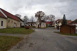 Centre of Stožice with the Chapel of Saints Simon and Jude | |
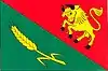 Flag 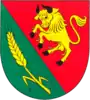 Coat of arms | |
 Stožice Location in the Czech Republic | |
| Coordinates: 49°7′57″N 14°9′0″E | |
| Country | |
| Region | South Bohemian |
| District | Strakonice |
| First mentioned | 1416 |
| Area | |
| • Total | 7.59 km2 (2.93 sq mi) |
| Elevation | 441 m (1,447 ft) |
| Population (2023-01-01)[1] | |
| • Total | 441 |
| • Density | 58/km2 (150/sq mi) |
| Time zone | UTC+1 (CET) |
| • Summer (DST) | UTC+2 (CEST) |
| Postal code | 389 01 |
| Website | www |
Administrative parts
Villages of Křepice and Libějovické Svobodné Hory are administrative parts of Stožice.
Geography
Stožice is located about 22 kilometres (14 mi) southeast of Strakonice and 28 km (17 mi) northwest of České Budějovice. It lies on the border of the České Budějovice Basin and Bohemian Forest Foothills. The highest point is the hill Svobodná hora at 640 metres (2,100 ft) above sea level.
History
The first written mention of Stožice is from 1416. In 1927, gold was discovered near the village of Křepice, and the village thus became the last place in the country where the gold rush occurred.[2]
Sights
The main sights are the neo-Gothic Chapel of Saints Simon and Jude, Chapel of Saint John of Nepomuk in Křepice, and the birthplace of writer Josef Holeček.[3]
Notable people
- Josef Holeček (1853–1929), writer
References
- "Population of Municipalities – 1 January 2023". Czech Statistical Office. 2023-05-23.
- "Historie" (in Czech). Obec Stožice. Retrieved 2021-08-23.
- "Památky" (in Czech). Obec Stožice. Retrieved 2021-08-23.