50th parallel north
The 50th parallel north is a circle of latitude that is 50 degrees north of the Earth's equatorial plane. It crosses Europe, Asia, the Pacific Ocean, North America, and the Atlantic Ocean.
.svg.png.webp)
At this latitude the sun is visible for 16 hours, 22 minutes during the summer solstice and 8 hours, 4 minutes during the winter solstice.[1] The maximum altitude of the sun during the summer solstice is 63.44 degrees and during the winter solstice it is 16.56 degrees. During the summer solstice, nighttime does not get beyond astronomical twilight, a condition which lasts throughout the month of June. Every day of the month of May can view both astronomical dawn and dusk.[2]
At this latitude, the average sea surface temperature between 1982 and 2011 was about 8.5 °C (47.3 °F).[3]
Around the world


Starting at the Prime Meridian and heading eastwards, the parallel 50° north passes through:
Sakhalin island

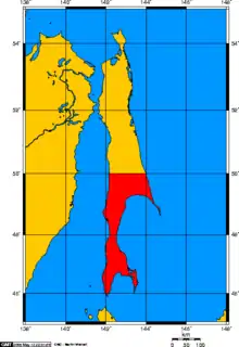
From the signing of the 1875 Treaty of Saint Petersburg until the Russo-Japanese War which broke in 1904, the Russian Empire had full control of Sakhalin island. As a result of the 1905 Treaty of Portsmouth that brought an end to the Russo-Japanese War, the portion of the island south of the 50th parallel line became Japanese territory, part of Karafuto Prefecture. However, following the month long Soviet–Japanese War during the summer of 1945, the entire island was reunified under Soviet control.[4]
See also
References
- "Duration of Daylight/Darkness Table for One Year". U.S. Naval Observatory. 2019-09-24. Archived from the original on 2019-10-12. Retrieved 2021-03-10.
- "Earth-Sun geometry - The Encyclopedia of Earth". www.eoearth.org.
- "Zonal Mean Sea Surface Temperatures (5 deg Latitude Bands) Average of Jan 1982 to Dec 2011". Retrieved July 7, 2022.
- Sevela, Mariya. "Sakhalin: the Japanese Under Soviet Rule". History Today. Retrieved 10 May 2014.

