Ahrori
Ahrori, also spelled Ahirori, is a village and corresponding community development block in Hardoi district of Uttar Pradesh, India.[1] Located 24 km from the city of Hardoi,[2][3] it hosts a regular market[1] and hosts a Babaji festival on Asadha Sudi 15 dedicated to worship of the goddess Devi.[4] The village has two primary schools and one clinic, as well as a public library and a sub post office.[1] As of 2011, the population of Ahrori is 8,382, in 1,329 households.[1]
Ahrori
Ahirori | |
|---|---|
Populated place | |
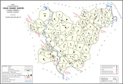 Map showing Ahrori (#318) in Ahrori CD block | |
| Country | |
| State | Uttar Pradesh |
| District | Hardoi |
| Area | |
| • Total | 12.386 km2 (4.782 sq mi) |
| Population (2011)[1] | |
| • Total | 8,382 |
| • Density | 680/km2 (1,800/sq mi) |
| Languages | |
| • Official | Hindi |
| Time zone | UTC+5:30 (IST) |
Demographic history
The 1961 census recorded Ahrori as comprising 6 hamlets, with a total population of 3,115 (1,763 male and 1,352 female), in 618 households and 531 physical houses.[4] The area of the village was given as 3,062 acres.[4] Average attendance of the Babaji fair was listed as about 500 people at the time.[4]
The 1981 census recorded Ahrori as having a population of 4,517, in 387 households, and covering an area of 1,238.79 hectares.[3]
Villages
Ahrori CD block has the following 96 villages:[1]
| Village name | Total land area (hectares) | Population (in 2011) |
|---|---|---|
| Neer | 1,480.5 | 7,266 |
| Mahuaipuri | 483.4 | 3,482 |
| Madara | 829.8 | 4,478 |
| Naya Gawn Muvarkpur | 328.4 | 3,194 |
| Khetuai | 483.4 | 4,379 |
| Pihiniya | 136 | 553 |
| Bingfil Ganj | 84 | 0 |
| Atwa Kataiyn | 905.3 | 5,622 |
| Sohasa | 448.6 | 2,177 |
| Kharda Khera | 755.7 | 5,739 |
| Ghoora | 141.1 | 1,073 |
| Bhurdiya | 272.3 | 1,202 |
| Paraspur | 559.9 | 4,544 |
| Ahirori (block headquarters) | 1,238.6 | 8,382 |
| Katka | 233.8 | 1,824 |
| Gopalpur | 196.6 | 1,116 |
| Saripur Bramhnan | 117 | 1,163 |
| Badauli | 601.1 | 2,798 |
| Baksapur | 310 | 2,205 |
| Hunsepur | 375.9 | 2,727 |
| Thok Kaboolpur | 267.5 | 2,029 |
| Dighiya | 247.7 | 1,665 |
| Dahee | 568.1 | 2,771 |
| Kuian | 379.7 | 2,015 |
| Naya Gaon Deoriya | 305.8 | 1,769 |
| Maheen Kund | 432.5 | 1,721 |
| Hasanapur | 77.7 | 443 |
| Karem Nagar Jalalpur | 502.6 | 2,208 |
| Raotapur | 292.9 | 980 |
| Sonoiya | 218.2 | 1,311 |
| Akbarpur | 256 | 1,141 |
| Sadiapur | 94.9 | 821 |
| Ayak Ghara | 525.3 | 2,348 |
| Bane Kuian | 311.1 | 1,999 |
| Chathiya | 144 | 804 |
| Majhola | 57.9 | 0 |
| Dhafrapur | 211.1 | 848 |
| Patteepur | 259.9 | 924 |
| Jamuniya | 223.2 | 1,361 |
| Gonda Rao | 542.3 | 4,853 |
| Mahmoodpur Bahadur | 58.8 | 737 |
| Gohraiya | 41.8 | 441 |
| Bajeedpur | 580.2 | 3,623 |
| Majhigawan Ramgulam | 292.8 | 867 |
| Shekhvapur | 42.3 | 0 |
| Armee | 498 | 1,925 |
| Govardhanpur | 563.8 | 3,404 |
| Kherwa Kamalpur | 276.5 | 1,535 |
| Hans Barauli | 324.4 | 2,142 |
| Sandana | 268.4 | 1,789 |
| Basen | 293.9 | 3,049 |
| Barkherwan | 374.8 | 2,696 |
| Athaua | 193.1 | 1,986 |
| Ahri | 823 | 3,751 |
| Gardeurn | 629.2 | 4,853 |
| Thok Bandho | 539 | 2,669 |
| Mangolapur | 772.8 | 3,647 |
| Bheetha Mahasingh | 309.8 | 1,733 |
| Sahulpur | 201.9 | 2,207 |
| Kot | 263.4 | 1,210 |
| Saareepur Heeralal | 132 | 1,744 |
| Kaimau | 370.9 | 3,217 |
| Behta Murtja Bax | 548.6 | 3,903 |
| Kesvan | 260.9 | 1,760 |
| Karim Nagar Saidapur | 877.3 | 7,463 |
| Kasmandee | 590.8 | 3,833 |
| Punniya | 312.8 | 2,697 |
| Karahi | 259.8 | 1,676 |
| Anua | 110.2 | 1,291 |
| Daudpur | 123.3 | 984 |
| Danmandi | 131.1 | 801 |
| Jarera | 46.8 | 633 |
| Baishpur | 58.5 | 516 |
| Balleepur | 760.2 | 5,161 |
| Fareedapur | 731.4 | 5,461 |
| Bamhna Kherda | 110.4 | 1,685 |
| Khajur Mai | 329.3 | 3,404 |
| Pipona | 354.4 | 2,139 |
| Kamolia | 241.9 | 1,446 |
| Gopar | 534.7 | 3,807 |
| Gadanpur | 491.4 | 3,348 |
| Rao Bahadur | 549.3 | 1,992 |
| Lodhi | 441.9 | 3,746 |
| Baghauli | 528.4 | 8,458 |
| Devgan | 86.2 | 655 |
| Neebhi | 132.7 | 1,038 |
| Gorda Dhar | 485.1 | 2,551 |
| Victoriya Ganj | 817.6 | 7,214 |
| Lokwapur | 342.2 | 1,939 |
| Bhitha Dan | 627.3 | 3,108 |
| Buorapur | 172.5 | 628 |
| Rampur Grant | 227.7 | 912 |
| Jasoo | 128.7 | 1,302 |
| Palpur Baragi Khera | 658.9 | 3,005 |
| Umrapur | 491.8 | 2,147 |
| Atra | 227.3 | 1,780 |
References
- "Census of India 2011: Uttar Pradesh District Census Handbook - Hardoi, Part A (Village and Town Directory)" (PDF). Census 2011 India. pp. 371–88. Retrieved 13 June 2021.
- Census 1971 Uttar Pradesh: District Census Handbook Part X-A: Village & Town Directory, District Hardoi (PDF). 1972. pp. 108–9. Retrieved 13 June 2021.
- Census 1981 Uttar Pradesh: District Census Handbook Part XIII-A: Village & Town Directory, District Hardoi (PDF). 1982. pp. 148–9. Retrieved 13 June 2021.
- Census 1961: District Census Handbook, Uttar Pradesh (36 - Hardoi District) (PDF). Lucknow. 1965. pp. 158–9, lxxii-lxxiii of section "Hardoi Tahsil". Retrieved 13 June 2021.
{{cite book}}: CS1 maint: location missing publisher (link)