Ampasina Maningory
Ampasina Maningory is a rural municipality in Madagascar, located along the Maningory River, a few kilometers from the Indian Ocean. It belongs to the district of Fenerive Est, which is a part of Analanjirofo Region. The population of the commune was estimated to be approximately 36,000 in 2001 commune census.[2]
Ampasina Maningory | |
|---|---|
 Ampasina Maningory Location in Madagascar | |
| Coordinates: 17°13′S 49°25′E | |
| Country | |
| Region | Analanjirofo |
| District | Fenerive Est |
| Government | |
| • Mayor | Alexis Ralisimanana |
| Area | |
| • Total | 215 km2 (83 sq mi) |
| Elevation | 17 m (56 ft) |
| Population (2001)[2] | |
| • Total | 36,000 |
| • Ethnicities | Betsimisaraka |
| Time zone | UTC3 (EAT) |
| Postal code | 509 |
Primary and junior level secondary education are available in town. The majority 95% of the population of the commune are farmers. The most important crop is cloves, while other important products are coffee and rice. Services provide employment for 2% of the population. Additionally fishing employs 3% of the population.[2]
Rivers
- The Maningory River crosses Ampasina Maningory and flows into the Indian Ocean at 6 km (3.7 mi) East of the town.
Roads
The National road No. 5 goes through Ampasina Maningory. It is located 19 km (12 mi) north of Fenoarivo Atsinanana (Fénérive Est) and 110 km (68 mi) north of Toamasina.
References
- DYNAMIQUES DES ASSOCIATIONS PAYSANNES DANS LE DEVELOPPEMENT RURAL
- "ILO census data". Cornell University. 2002. Retrieved 2008-03-07.
Capital: Fenoarivo Atsinanana | ||
| Fenerive Est (509) | 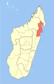 | |
| Mananara Nord (511) | ||
| Maroantsetra (512) | ||
| Sainte Marie (Nosy Boraha) (515) | ||
| Soanierana Ivongo (516) | ||
| Vavatenina (518) | ||
6 districts; 71 communes | ||