Rantabe
Rantabe is a rural municipality in Madagascar. It belongs to the district of Maroantsetra, which is a part of Analanjirofo Region. The population of the commune was estimated to be approximately 20,000 in 2001 commune census.[2]
Rantabe
Rantabe | |
|---|---|
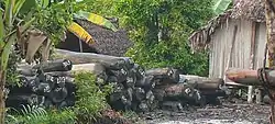 Rosewood lodges at Rantabe waterline | |
 Rantabe Location in Madagascar | |
| Coordinates: 15°42′S 49°39′E | |
| Country | |
| Region | Analanjirofo |
| District | Maroantsetra |
| Elevation | 17 m (56 ft) |
| Population (2001)[2] | |
| • Total | 20,000 |
| Time zone | UTC3 (EAT) |
| Postal code | 512 |
Rantabe has a riverine harbour. Primary and junior level secondary education are available in town. The majority 82% of the population of the commune are farmers. The most important crops are rice and vanilla, while other important agricultural products are coffee and cloves. Services provide employment for 12% of the population. Additionally fishing employs 6% of the population.[2]
Roads
The town is situated at the N5, south of the mouth of the Rantabe river into the Indian Ocean.
Nature
See also
- James Plaintain - a pirate that settled in Rantabe.
References
- Estimated based on DEM data from Shuttle Radar Topography Mission
- "ILO census data". Cornell University. 2002. Retrieved 2008-03-08.
Wikimedia Commons has media related to Rantabe.
Capital: Fenoarivo Atsinanana | ||
| Fenerive Est (509) | 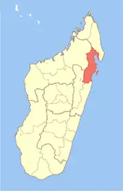 | |
| Mananara Nord (511) | ||
| Maroantsetra (512) | ||
| Sainte Marie (Nosy Boraha) (515) | ||
| Soanierana Ivongo (516) | ||
| Vavatenina (518) | ||
6 districts; 71 communes | ||
This article is issued from Wikipedia. The text is licensed under Creative Commons - Attribution - Sharealike. Additional terms may apply for the media files.