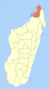
Andranovondronina
Andranovondronina is a municipality in northern Madagascar, along with holding the status as most northern town on the island. It belongs to the district of Antsiranana II, which is a part of the Diana Region. According to the 2001 census the population of Andranovondronina was 2,372.[2]
Andranovondronina | |
|---|---|
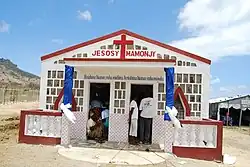 the church of Bobaomby, a village of this municipality | |
 Andranovondronina Location in Madagascar | |
| Coordinates: 12°3′17.2″S 49°13′57.3″E | |
| Country | |
| Region | Diana |
| District | Antsiranana II |
| Elevation | 62 m (203 ft) |
| Population (2001)[2] | |
| • Total | 2,372 |
| Time zone | UTC+3 (EAT) |
| Postal code | 202 |
Only primary schooling is available in the town. Agriculture provides employment for 14% and 75% of the working population. The principal crop is maize, while other important products are cassava and rice. Services provide employment for 0.5% of the population. Additionally fishing employs 10.5% of the population.[2]
Cap Ambre
The northernmost point in Madagascar is situated in this municipality: the Cape Ambre or Tanjona Bobaomby.[3] The creation of a national park is under way in this area.
References and notes
- Estimated based on DEM data from Shuttle Radar Topography Mission
- "ILO census data". Cornell University. 2002. Retrieved 13 February 2008.
- Bobaomby
| Ambanja (24) - 203 |
|  |
|---|---|---|
| Ambilobe (15) - 204 | ||
| Antsiranana (Diego Suarez) (1) - 201 | ||
| Antsiranana II (22) - 202 |
| |
| Nosy Be (5) - 207 |
| |
5 districts; 51 communes | ||