Tanambao Marivorahona
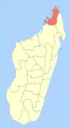
Marivorahona or Tanambao Marivorahona is a municipality (French: commune, Malagasy: kaominina) in northern Madagascar. It belongs to the district of Ambilobe, which is a part of Diana Region.
Tanambao Marivorahona
Marivorahona | |
|---|---|
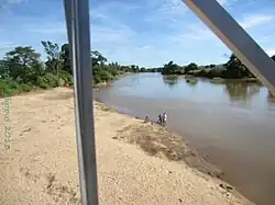 Manajeba River at Marivorahona | |
 Tanambao Marivorahona Location in Madagascar | |
| Coordinates: 13°5′S 49°5′E | |
| Country | |
| Region | Diana |
| District | Ambilobe |
| Government | |
| • Mayor | Justin Bemiarina |
| Elevation | 24 m (79 ft) |
| Population (2018)[2] | |
| • Total | 15,654 |
| Time zone | UTC3 (EAT) |
| Postal code | 204 |
According to 2018 census the population of Tanambao Marivorahona was 15,654.
Only primary schooling is available in town. The majority (94%) of the population are farmers. The most important crops are sugarcane and tomato, while other important agricultural products are cotton, sweet potato and rice. Industry and services both provide employment for 3% of the population.[3]
Geographie
Tanambao Marivorahona lies 13 km from Ambilobe and 123 km from Antsiranana (Diego Suarez) on the RN 6[4] in the fertile plains of the Manajeba River. It covers also the villages (fokontany) of Ananjaka, Antsatrambalo, Ambodiampana, Mahamasina, Bobasatrana, Isesy, Mahavelona, Marivorahona, Tanambao Marivorahona and Betsimiranjana.[5]
The entrance of the Ankarana Reserve is in Mahamasina.
References
- Estimated based on DEM data from Shuttle Radar Topography Mission
- Census 2018
- "ILO census data". Cornell University. 2002. Retrieved 2008-02-13.
- L'Express Madagascar
- www.mef.gov.mg - DECRET n°2015–592 portant classement des Communes en Communes urbaines ou en Communes rurales.
| Ambanja (24) - 203 |
|  |
|---|---|---|
| Ambilobe (15) - 204 | ||
| Antsiranana (Diego Suarez) (1) - 201 | ||
| Antsiranana II (22) - 202 |
| |
| Nosy Be (5) - 207 |
| |
5 districts; 51 communes | ||