Bảo Lạc district
Bảo Lạc is a rural district of Cao Bằng province in the Northeast region of Vietnam. As of 2019 the district had a population of 54,420.[1] The district covers an area of 919 km2. The district capital lies at Bảo Lạc.[2]
Bảo Lạc District
Huyện Bảo Lạc | |
|---|---|
| Country | |
| Region | Northeast |
| Province | Cao Bằng |
| Capital | Bảo Lạc |
| Area | |
| • Total | 355 sq mi (919 km2) |
| Population (2019)[1] | |
| • Total | 54,420 |
| • Density | 150/sq mi (59/km2) |
| Time zone | UTC+7 (Indochina Time) |
Administrative divisions
Bảo Lạc District consists of the district capital, Bảo Lạc, and 16 communes: Sơn Lộ, Đình Phùng, Hưng Đạo, Huy Giáp, Hồng An, Xuân Trường, Khánh Xuân, Phan Thanh, Hồng Trị, Cô Ba, Bảo Toàn, Cốc Pàng, Thượng Hà, Hưng Thịnh, Sơn Lập and Kim Cúc.
Climate
| Climate data for Bảo Lạc | |||||||||||||
|---|---|---|---|---|---|---|---|---|---|---|---|---|---|
| Month | Jan | Feb | Mar | Apr | May | Jun | Jul | Aug | Sep | Oct | Nov | Dec | Year |
| Record high °C (°F) | 32.2 (90.0) |
36.0 (96.8) |
37.5 (99.5) |
39.7 (103.5) |
41.6 (106.9) |
40.5 (104.9) |
39.8 (103.6) |
39.3 (102.7) |
38.5 (101.3) |
36.4 (97.5) |
34.5 (94.1) |
32.5 (90.5) |
41.6 (106.9) |
| Average high °C (°F) | 19.9 (67.8) |
21.9 (71.4) |
25.8 (78.4) |
30.0 (86.0) |
32.6 (90.7) |
33.2 (91.8) |
33.5 (92.3) |
33.3 (91.9) |
32.1 (89.8) |
28.9 (84.0) |
25.3 (77.5) |
21.7 (71.1) |
28.2 (82.8) |
| Daily mean °C (°F) | 14.7 (58.5) |
16.7 (62.1) |
20.4 (68.7) |
24.2 (75.6) |
26.6 (79.9) |
27.6 (81.7) |
27.7 (81.9) |
27.2 (81.0) |
25.7 (78.3) |
22.9 (73.2) |
19.1 (66.4) |
15.6 (60.1) |
22.4 (72.3) |
| Average low °C (°F) | 11.9 (53.4) |
13.6 (56.5) |
16.8 (62.2) |
20.4 (68.7) |
22.8 (73.0) |
24.2 (75.6) |
24.5 (76.1) |
24.0 (75.2) |
22.4 (72.3) |
19.7 (67.5) |
15.9 (60.6) |
12.3 (54.1) |
19.0 (66.2) |
| Record low °C (°F) | −0.1 (31.8) |
3.5 (38.3) |
4.4 (39.9) |
9.3 (48.7) |
13.6 (56.5) |
16.3 (61.3) |
18.5 (65.3) |
18.5 (65.3) |
13.6 (56.5) |
8.6 (47.5) |
4.6 (40.3) |
−0.1 (31.8) |
−0.1 (31.8) |
| Average precipitation mm (inches) | 24.9 (0.98) |
23.3 (0.92) |
45.2 (1.78) |
72.7 (2.86) |
158.6 (6.24) |
215.5 (8.48) |
238.9 (9.41) |
210.2 (8.28) |
104.1 (4.10) |
72.6 (2.86) |
42.2 (1.66) |
24.4 (0.96) |
1,232.6 (48.53) |
| Average rainy days | 4.9 | 4.5 | 5.2 | 8.3 | 13.1 | 16.6 | 18.1 | 17.1 | 10.6 | 9.0 | 6.4 | 4.0 | 117.8 |
| Average relative humidity (%) | 81.5 | 78.9 | 76.4 | 76.3 | 77.9 | 82.5 | 84.3 | 85.2 | 84.2 | 84.3 | 83.8 | 82.5 | 81.4 |
| Mean monthly sunshine hours | 67.7 | 86.8 | 84.7 | 131.4 | 173.9 | 144.0 | 158.1 | 161.2 | 149.9 | 120.5 | 107.5 | 90.3 | 1,477 |
| Source: Vietnam Institute for Building Science and Technology[3] | |||||||||||||
References
- General Statistics Office of Vietnam (2019). "Completed Results of the 2019 Viet Nam Population and Housing Census" (PDF). Statistical Publishing House (Vietnam). ISBN 978-604-75-1532-5.
- "Districts of Vietnam". Statoids. Archived from the original on 1 March 2009. Retrieved March 13, 2009.
- "Vietnam Institute for Building Science and Technology" (PDF). Retrieved 16 August 2023.
| Bắc Giang province | 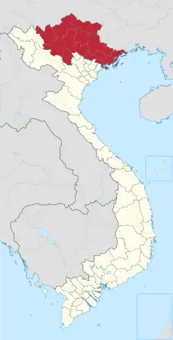 | |
|---|---|---|
| Bắc Kạn province | ||
| Cao Bằng province | ||
| Hà Giang province | ||
| Lạng Sơn province | ||
| Phú Thọ province | ||
| Quảng Ninh province |
| |
| Thái Nguyên province | ||
| Tuyên Quang province | ||
※ denotes provincial seat. | ||

This article is issued from Wikipedia. The text is licensed under Creative Commons - Attribution - Sharealike. Additional terms may apply for the media files.