Nguyên Bình district
Nguyên Bình is a rural district of Cao Bằng province in the Northeast region of Vietnam. As of 2003 the district had a population of 39,153.[1] The district covers an area of 837 km². The district capital lies at Nguyên Bình.[1]
Nguyên Bình district
Huyện Nguyên Bình | |
|---|---|
 Capital of Nguyên Bình district | |
| Country | |
| Region | Northeast |
| Province | Cao Bằng |
| Capital | Nguyên Bình |
| Area | |
| • Total | 323 sq mi (837 km2) |
| Population (2003) | |
| • Total | 39,153 |
| Time zone | UTC+7 (Indochina Time) |
Administrative divisions
Nguyên Bình District consists of the state capital, Nguyên Bình, and 19 communes: Tĩnh Túc, Thịnh Vượng, Hoa Thám, Lang Môn, Tam Kim, Hưng Đạo, Quang Thành, Thành Công, Phan Thanh, Mai Long, Ca Thành, Vũ Nông, Yên Lạc, Triệu Nguyên, Thể Dục, Thái Học, Minh Thanh, Bắc Hợp and Minh Tâm.
Climate
| Climate data for Nguyên Bình | |||||||||||||
|---|---|---|---|---|---|---|---|---|---|---|---|---|---|
| Month | Jan | Feb | Mar | Apr | May | Jun | Jul | Aug | Sep | Oct | Nov | Dec | Year |
| Record high °C (°F) | 29.2 (84.6) |
33.5 (92.3) |
34.4 (93.9) |
37.0 (98.6) |
37.2 (99.0) |
37.0 (98.6) |
36.4 (97.5) |
36.9 (98.4) |
35.5 (95.9) |
33.1 (91.6) |
31.2 (88.2) |
30.3 (86.5) |
37.2 (99.0) |
| Average high °C (°F) | 16.7 (62.1) |
18.3 (64.9) |
22.0 (71.6) |
26.3 (79.3) |
29.3 (84.7) |
30.4 (86.7) |
30.7 (87.3) |
30.6 (87.1) |
29.4 (84.9) |
26.5 (79.7) |
22.7 (72.9) |
19.0 (66.2) |
25.2 (77.4) |
| Daily mean °C (°F) | 12.4 (54.3) |
14.2 (57.6) |
17.6 (63.7) |
21.7 (71.1) |
24.6 (76.3) |
26.0 (78.8) |
26.1 (79.0) |
25.6 (78.1) |
24.2 (75.6) |
21.4 (70.5) |
17.5 (63.5) |
13.8 (56.8) |
20.4 (68.7) |
| Average low °C (°F) | 9.7 (49.5) |
11.5 (52.7) |
14.7 (58.5) |
18.5 (65.3) |
21.3 (70.3) |
22.9 (73.2) |
23.1 (73.6) |
22.5 (72.5) |
20.9 (69.6) |
18.2 (64.8) |
14.2 (57.6) |
10.5 (50.9) |
17.4 (63.3) |
| Record low °C (°F) | −0.6 (30.9) |
0.2 (32.4) |
4.1 (39.4) |
8.4 (47.1) |
13.2 (55.8) |
15.4 (59.7) |
17.5 (63.5) |
16.5 (61.7) |
13.6 (56.5) |
6.5 (43.7) |
3.1 (37.6) |
−1.2 (29.8) |
−1.2 (29.8) |
| Average precipitation mm (inches) | 44.2 (1.74) |
36.9 (1.45) |
60.3 (2.37) |
93.0 (3.66) |
210.3 (8.28) |
297.2 (11.70) |
309.8 (12.20) |
310.5 (12.22) |
200.3 (7.89) |
108.1 (4.26) |
58.9 (2.32) |
36.1 (1.42) |
1,761.4 (69.35) |
| Average rainy days | 12.6 | 12.3 | 12.5 | 12.5 | 15.2 | 18.0 | 19.9 | 18.9 | 13.5 | 10.9 | 8.9 | 8.4 | 163.4 |
| Average relative humidity (%) | 83.6 | 83.7 | 83.0 | 81.8 | 80.6 | 82.8 | 84.6 | 84.9 | 82.8 | 81.3 | 81.0 | 81.3 | 82.6 |
| Source: Vietnam Institute for Building Science and Technology[2] | |||||||||||||
References
- "Districts of Vietnam". Statoids. Retrieved March 13, 2009.
- "Vietnam Institute for Building Science and Technology" (PDF). Retrieved 16 August 2023.
| Bắc Giang province | 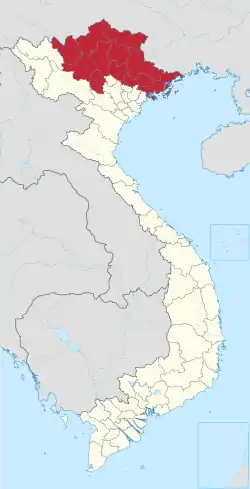 | |
|---|---|---|
| Bắc Kạn province | ||
| Cao Bằng province | ||
| Hà Giang province | ||
| Lạng Sơn province | ||
| Phú Thọ province | ||
| Quảng Ninh province |
| |
| Thái Nguyên province | ||
| Tuyên Quang province | ||
※ denotes provincial seat. | ||

This article is issued from Wikipedia. The text is licensed under Creative Commons - Attribution - Sharealike. Additional terms may apply for the media files.