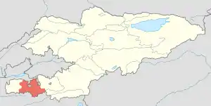
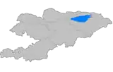
Batken District
Batken (Kyrgyz: Баткен району) is a district of Batken Region in south-western Kyrgyzstan. Its area is 5,948 square kilometres (2,297 sq mi),[1] and its resident population was 91,983 in 2021.[2] The administrative seat lies at the city Batken, itself not part of the district.[3]
Batken
Баткен району | |
|---|---|
 | |
| Country | Kyrgyzstan |
| Region | Batken Region |
| Capital | Batken |
| Area | |
| • Total | 5,948 km2 (2,297 sq mi) |
| Population (2021) | |
| • Total | 91,983 |
| • Density | 15/km2 (40/sq mi) |
| Time zone | UTC+6 |
Population
| Year | Pop. | ±% p.a. |
|---|---|---|
| 1970 | 28,553 | — |
| 1979 | 38,434 | +3.36% |
| 1989 | 55,799 | +3.80% |
| 1999 | 77,374 | +3.32% |
| 2009 | 69,591 | −1.05% |
| 2021 | 91,983 | +2.35% |
| Note: resident population, before 2000 including Batken city; Sources:[1][2] | ||
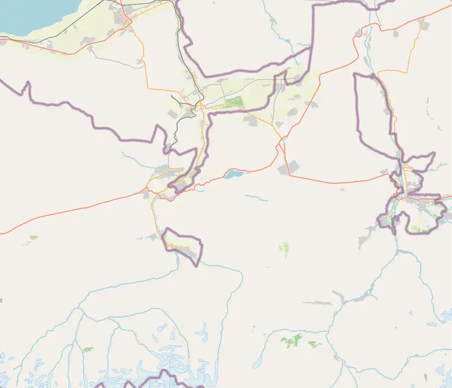
Populated places
In total, Batken District includes 47 settlements in 9 rural communities (ayyl aymagy). Each rural community can consist of one or several villages. The rural communities and settlements in the Batken District are:[3][1]
- Ak-Say (seat: Ak-Say; incl. Kök-Tash, Üch-Döbö, Kapchygay, Tashtumshuk and Ming-Bulak)
- Ak-Tatyr (seat: Ak-Tatyr; incl. Ravat and Govsuvar (Orto-Boz))
- Darya (seat: Chek; incl. Jangyryk, Tunuk-Suu, Kan, Tabylgy, Kayyngdy, Sary-Talaa, Korgon-Tash and Jangy-Jer)
- Kara-Bak (seat: Kara-Bak; incl. Dostuk, Kyzyl-Bel, Chet-Kyzyl, Zardaly, Dobo and Bay Kara-Bak)
- Kara-Bulak (seat: Bujum; incl. Kara-Bulak)
- Kyshtut (seat: Tayan; incl. Gaz, Kyshtut, Say, Sogment and Charbak)
- Samarkandek (seat: Samarkandek; incl. Jangy-Bak, Pasky-Aryk and Ming-Örük)
- Suu-Bashy (seat: Boz-Adyr; incl. Apkan, Böjöy, Kara-Tokoy and Aygül-Tash)
- Tört-Kül (seat: Chong-Talaa; incl. Ak-Ötök, Ak-Turpak, Zar-Tash and Chongara)
Bulak-Bashy
Bazar-Bashy
Jangyryk
Tunuk-Suu
Tabylgy→
↑
Kayyngdy
Kayyngdy
↑
Sary-
Talaa
Sary-
Talaa
Chong-Talaa
Ak-Ötök
Ak-Turpak
Chongara
Dostuk
Chet-Kyzyl
Dobo
Bay Kara-Bak
Kyshtut
Say
Sogment→
Charbak
Jangy-Bak
Pasky-Aryk
Ming-Öruk
Ak-Say
Kök-Tash
↑
Üch-
Döbö
Üch-
Döbö
Kapchygay
Tashtumshuk→
Ming-Bulak
Ak-Tatyr
←Govsuvar
Boz-Adyr
Apkan
↑
Kara-
Tokoy
Kara-
Tokoy
Aygül-
Tash
Tash
Settlements of the Batken District
References
- "2009 population and housing census of the Kyrgyz Republic: Batken Region" (PDF) (in Russian). National Statistics Committee of the Kyrgyz Republic. 2010. pp. 14, 17.
- "Population of regions, districts, towns, urban-type settlements, rural communities and villages of Kyrgyz Republic" (XLS) (in Russian). National Statistics Committee of the Kyrgyz Republic. 2021. Archived from the original on 10 November 2021.
- "Classification system of territorial units of the Kyrgyz Republic" (in Kyrgyz). National Statistics Committee of the Kyrgyz Republic. May 2021. pp. 39–40.
| North Kyrgyzstan |
|  Raions of Kyrgyzstan | ||||||||||
|---|---|---|---|---|---|---|---|---|---|---|---|---|
| South Kyrgyzstan |
| |||||||||||
This article is issued from Wikipedia. The text is licensed under Creative Commons - Attribution - Sharealike. Additional terms may apply for the media files.