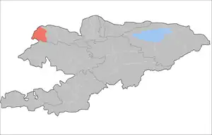
Kara-Buura District
Kara-Buura (Kyrgyz: Кара-Буура району, romanized: Kara-Buura rayonu) is a district of Talas Region, in north-western Kyrgyzstan. Its area is 4,216 square kilometres (1,628 sq mi),[1] and its resident population was 69,180 in 2021.[2] The administrative seat lies at Kyzyl-Adyr.[3]
Kara-Buura
Кара-Буура району | |
|---|---|
 | |
| Country | Kyrgyzstan |
| Region | Talas Region |
| Area | |
| • Total | 4,216 km2 (1,628 sq mi) |
| Population (2021) | |
| • Total | 69,180 |
| • Density | 16/km2 (42/sq mi) |
| Time zone | UTC+6 |
Population
| Year | Pop. | ±% p.a. |
|---|---|---|
| 1970 | 35,841 | — |
| 1979 | 41,270 | +1.58% |
| 1989 | 47,272 | +1.37% |
| 1999 | 49,879 | +0.54% |
| 2009 | 58,056 | +1.53% |
| 2021 | 69,180 | +1.47% |
| Note: resident population; Sources:[1][2] | ||
Rural communities and villages
In total, Kara-Buura District includes 23 settlements in 10 rural communities (ayyl aymagy). Each rural community can consist of one or several villages. The rural communities and settlements in the Kara-Buura District are:[3][4][5]
- Ak-Chiy (seat: Joon-Döbö; incl. Jiyde)
- Amanbaev (seat: Amanbaev; incl. Ak-Jar, Kuru-Maymak and Suulu-Maymak)
- Bakayyr (seat: Ak-Bashat; incl. Kara-Say)
- Bakyyan (seat: Bakyyan; incl. Tamchy-Bulak and Kamash)
- Beysheke (seat: Beysheke; incl. Kara-Buura and Kara-Suu)
- Cholponbay (seat: Chymgent; incl. Kök-Döbö)
- Kara-Buura (seat: Kyzyl-Adyr; incl. Chong-Kara-Buura and Üch-Bulak)
- Kök-Say (seat: Kök-Say; incl. Kaynar)
- Maymak (seat: Maymak)
- Sheker (seat: Sheker; incl. Archagul)
Joon-Döbö
Jiyde
Beysheke
Kara-Buura
Kara-Suu
Bakyyan
Tamchy-Bulak
Kamash
Ak-Jar
Kuru-Maymak
Suulu-Maymak
Ak-Bashat
Kara-Say
Chong-Kara-Buura
Üch-Bulak
Kök-Döbö
Archagul
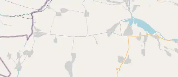
Settlements of the Kara-Buura District.
References
- "2009 population and housing census of the Kyrgyz Republic: Talas Region" (PDF) (in Russian). National Statistics Committee of the Kyrgyz Republic. 2010. pp. 12, 15.
- "Population of regions, districts, towns, urban-type settlements, rural communities and villages of Kyrgyz Republic" (XLS) (in Russian). National Statistics Committee of the Kyrgyz Republic. 2021. Archived from the original on 10 November 2021.
- "Classification system of territorial units of the Kyrgyz Republic" (in Kyrgyz). National Statistics Committee of the Kyrgyz Republic. May 2021. pp. 63–64.
- List of rural communities of Kyrgyzstan Archived 2010-02-09 at the Wayback Machine
- Law 27 September 2012 No. 168 on the transformation of individual urban settlements of the Kyrgyz Republic and relating them to the category of village or city
| North Kyrgyzstan |
|  Raions of Kyrgyzstan | ||||||||||
|---|---|---|---|---|---|---|---|---|---|---|---|---|
| South Kyrgyzstan |
| |||||||||||
This article is issued from Wikipedia. The text is licensed under Creative Commons - Attribution - Sharealike. Additional terms may apply for the media files.