Batroun
Batroun (Arabic: ٱلْبَتْرُون al-Batrūn; Christian and Jewish Palestinian Aramaic: בִתרוֹן Biṯron "the Cleft") is a coastal city in northern Lebanon and one of the oldest continuously inhabited cities in the world. It is the capital city of Batroun District.
Batroun
البترون | |
|---|---|
City | |
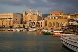 The port at the old city of Batroun with the St. Stephens Church | |
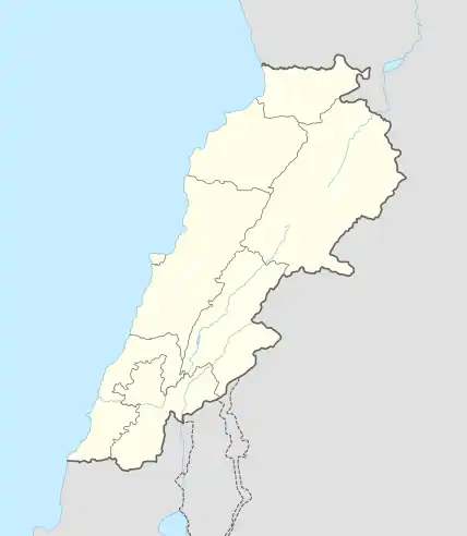 Batroun Location of Batroun within Lebanon | |
| Coordinates: 34°15′0″N 35°39′0″E | |
| Country | |
| Governorate | North Governorate |
| District | Batroun District |
| Government | |
| • Mayor | Marcelino Al Hark |
| Elevation | 34 m (112 ft) |
| Population | |
| • Total | 45,000 |
| Time zone | UTC+2 (EET) |
| • Summer (DST) | UTC+3 (EEST) |
| Dialing code | +961 (6) Landline |
Etymology
Batroun appears in Western Aramaic,[1] and is attested in as bṯrwn (Arabic: بثرون) in premodern Arabic texts, with the expected lenition of t for an Aramaic term.[2] Elie Mardini suggests the shift of the th to t in Aramaic terms in the Levant is due to the merger of certain fricatives in Levantine Arabic.[3]
Economy and urban development
Historically, the city of Batroun was settled at the interface between the sea and the national road that connected Beirut to Tripoli.
Lately, the radical shift of the historical functions of the local economic tissue into a leisure service-based economy (nightclubs, bars, restaurants, stores, etc.) has become the unique and only lever of the development of the city.[4] The economic metamorphosis has resulted in the resettlement of housing towards emerging city suburbs (nearby hills: New Batroun, Batroun Hills, Basbina, etc.) consequently to the overvaluation of the real estate market in the city centre. It clearly reveals here the constitution of a business city-centre (dedicated to leisure and business) balanced by the constitution of residential suburbs, where accelerated urban sprawl has led to the destruction of natural lands (pinewood and orange groves) and to the fatal rise in land prices.[5]
Tourism
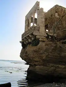
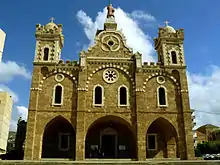
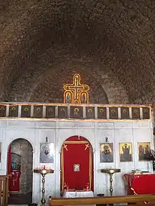
Batroun is a major tourist destination in North Lebanon. The town boasts historic Maronite and Greek Orthodox churches. The town is also a major beach resort with a vibrant nightlife that includes pubs and nightclubs. Citrus groves surround Batroun, and the town has been famous (from the early twentieth century) for its fresh lemonade sold at the cafés and restaurants on its main street. Biking along the Batroun coastline is also a major activity namely in late summer days. In 2009, the Batroun International Festival was born. It began hosting leading local and international artists. The festival takes place usually in July and/or August of each year in the old harbor area.
Demography
The people of Batroun are mainly Maronite, Melkite, and Greek Orthodox Christians. Batroun is a Roman Catholic (Latin rite) Titular See.[6][7][8]
History
Batroun is likely the "Batruna" mentioned in the Amarna letters dating to the 14th century B.C. Batroun was mentioned by the ancient geographers Strabo, Pliny, Ptolemy, Stephanus of Byzantium, and Hierocles. Theophanes the Confessor called the city "Bostrys."[9]
The Phoenicians founded Batroun on the southern side of the promontory called in classical antiquity Theoprosopon and during the Byzantine Empire, Cape Lithoprosopon. Batroun is said to have been founded by Ithobaal I (Ethbaal), king of Tyre, whose daughter Jezabel (897–866 B.C.) married Ahab.[10]
The city was under Roman rule to Phoenice Province, and later after the region was Christianized became a suffragan of the Patriarch of Antioch.
In 551, Batroun was destroyed by an earthquake, which also caused mudslides and made the Cape Lithoprosopon crack.[11] Historians believe that Batroun's large natural harbor was formed during the earthquake.[12]
Three Greek Orthodox bishops are known to have come from Batroun: Porphyrius in 451, Elias about 512 and Stephen in 553 (Lequien, II, 827). According to a Greek Notitia episcopatuum, the Greek Orthodox See has existed in Batroun since the tenth century when the city was then called Petrounion. After the Muslim conquests of the region, the name was Arabicized to Batroun.
Batroun was controlled by the Crusaders in 1104,[13] to be known as the Lordship of Botrun as part of the County of Tripoli, until it was conquered by the Mamluk Sultanate in 1289.[14] One of Batroun's archaeological sites is Mseilha Fort, which is constructed on an isolated massive rock with steep sides protruding in the middle of a plain surrounded by mountains.[15]
Under Ottoman rule, Batroun was the centre of a kaza in the mutessariflik of Lebanon and the seat of a Maronite diocese, suffragan to the Maronite Catholic Patriarchate of Antioch. Since 1999, it has been the seat of the Maronite eparchy.[16]
Politics
Elections, municipal and parliamentary, in Batroun have seen increasing interest, namely in the context of local and national struggle for power. The current serving Mayor of Batroun is Marcelino El Harek.
Landmarks
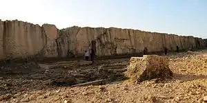
- The Ancient Sea Wall
- El-Bahsa beach
- Makaad El Mir
- El-Mseilha Fort
- St. Stephan's Cathedral
- Historic Souk
See also
References
- "The Comprehensive Aramaic Lexicon". cal.huc.edu.
- Pat-El, Naʾama; Stokes, Phillip W (24 August 2022). "The 'Aramaic Substrate' Hypothesis in the Levant Revisited". Journal of Semitic Studies. 67 (2): 24. doi:10.1093/jss/fgac002.
- Pat-El, Naʾama; Stokes, Phillip W (24 August 2022). "The 'Aramaic Substrate' Hypothesis in the Levant Revisited". Journal of Semitic Studies. 67 (2): 24. doi:10.1093/jss/fgac002.
- Sfeir, Nagi (August 2018). "Local economic development via urbanism lever: the case of Lebanon" (PDF). SAUES Journal. 1 (2): 62–78. doi:10.22034/saues.2018.02.01. Archived from the original (PDF) on 2019-05-02. Retrieved 2019-05-02.
- Sfeir, Nagi (2013). "Realurbanism: or the Urban Realpolitik. Towards a " Spatialisation " of the Realist Paradigm from International Relations Theories »" (PDF). Journal of Settlements and Spatial Planning. 4 (1): 1–10.
- "Catholic Encyclopedia: Bothrys". Newadvent.org. Retrieved 2012-11-12.
- "Botrys". Catholic-Hierarchy.org. David M. Cheney. Retrieved 23 January 2015.
- David M. Cheney (2012-10-24). "Its Bishops and Dioceses, Current and Past". Catholic-Hierarchy. Retrieved 2012-11-12.
- Malalas, Chronogr., XVIII, in P.G., XCVII, 543, cited in Bothrys - Catholic Encyclopedia article
- (Menander, in Josephus, Antiquities of the Jews, VIII, xiii, 2), cited in Bothrys - Catholic Encyclopedia article
- Malalas, Chronogr., XVIII, in P.G., XCVII, 704, cited in Bothrys - Catholic Encyclopedia article
- "The historical earthquakes of Syria: an analysis of large and moderate earthquakes from 1365 B.C. to 1900 A.D." (PDF). Earth-prints.org. Retrieved 2012-11-12.
- Barber 2012, p. 98.
- Runciman 1989, p. 407.
- Batroun.com Archived 2010-04-16 at the Wayback Machine - Batroun Official Website
- "Eparchy of Batrun (Maronite)". Catholic-Hierarchy.org. David M. Cheney. Retrieved 23 January 2015.
- Citations
- Barber, Malcolm (2012). The Crusader States. Yale University Press. ISBN 978-0-300-11312-9.
- Runciman, Steven (1989). A History of the Crusades, Volume III: The Kingdom of Acre and the Later Crusades. Cambridge University Press. ISBN 0-521-06163-6.
