Buner District
Buner District (Pashto: بونېر ولسوالۍ, Urdu: ضلع بونیر) is a district in the Malakand Division of the Khyber Pakhtunkhwa province of Pakistan. Buner is famous for Hospitality and also called the land of Hospitality. Before receiving the status of a district in 1991, it was a tehsil within Swat District.[5]
Buner District
ضلع بونیر بونېر ولسوالۍ | |
|---|---|
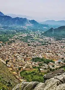
  Top: Mountains near Sar Teeraj Bottom: Buddhist ruins of Ranigat | |
| Nickname: Gul Da Namair[1] | |
| Motto: The Land of sufis اولیاء کی سرزمین | |
.svg.png.webp) Location in the province of Khyber Pakhtunkhwa | |
| Country | |
| Province | |
| Division | Malakand |
| District | 1998 |
| Headquarters | Daggar[2] |
| Government | |
| • Type | District Administration |
| • Deputy Commissioner | Nasrullah Khan Yousafzai |
| • District Police Officer | Imran Khan |
| • District Health Officer | N/A |
| Area | |
| • Total | 1,865 km2 (720 sq mi) |
| Population | |
| • Total | 895,460 |
| • Density | 480/km2 (1,200/sq mi) |
| Demonym | Buneri |
| Time zone | UTC+5 (PST) |
| Postal code of Daggar | 19290 |
| Area code | 0939 |
| Number of Tehsils | 6 |
| Number of Union Councils | 27[4] |
| Website | buner |

History

The Buner Valley lies between Swabi to the South and Swat to the North. It is a valley dotted with villages and divided into four sub-divisions. The Mora Hills and the Ilam range divide it from the Swat Valley, while the Sinawar range from Yusafzai, the Guru mountains from the Mardan Valley, and the Duma range from the Puran Valley.[6]
During the 1580s, a significant uprising against the Mughal Empire took place among Yusufzai people .[7] In late 1585, Mughal Emperor Akbar sent military forces under Zain Khan Koka and Birbal to crush the rebellion. In February 1586, near the Karakar Pass, about 8,000 Mughal soldiers, including Birbal, were killed by the Yusufzai lashkar, led by Kalu Khan. This was the greatest disaster faced by the Mughal Army during Akbar's reign.[8]
Throughout the 19th century, the inhabitants of Buner stood up twice against the British Raj.[9]
In April 2009, the Tehrik-i-Taliban Pakistan seized control of Buner after a short battle with the local residents. The TTP then began imposing strict regulations, which reportedly included the closure of video stores, mandates against trimming beards, and restrictions on women's presence in various public spaces.[10] On 29 April, the Government of Pakistan responded to the Taliban by deploying the army to the region, even employing parachutists delivered via helicopters.[11] By the end of May 2009, almost whole Buner was liberated from the Taliban's grip.[12]

Demographics
| Year | Pop. | ±% p.a. |
|---|---|---|
| 1951 | 109,147 | — |
| 1961 | 123,217 | +1.22% |
| 1972 | 187,984 | +3.91% |
| 1981 | 265,517 | +3.91% |
| 1998 | 506,048 | +3.87% |
| 2017 | 895,460 | +3.05% |
| Sources:[13] | ||
At the time of the 2017 census, the district had 92,990 households and a population of 895,460, of which 445,872 were males 449,555were females. The entire population was rural. Buner had a sex ratio of 1008 females per 1000 males and a literacy rate of 46.84% - 65.10% for males and 29.40% for females. 32.18% of the population were under 10 years of age. 1,402 (0.16%) people in the district were from religious minorities, mainly Sikhs.[3]
At the time of the 2017 census, 97.56% of the population spoke Pashto and 0.95% Hindko as their first language.[3]
Administration
Buner Tehsils
Buner District is currently subdivided into 6 Tehsils.
- Daggar (Urdu: تحصیل ڈگر)(Pashto: ډاګر تحصیل)
- Chagharzai (Urdu: تحصیل چغرزئی)(Pashto: چغرزي تحصیل)
- Chamla (Mandanr) (Urdu: تحصیل چملہ)(Pashto: چملا تحصیل)
- Khudu Khel (Urdu: تحصیل خدو خیل)(Pashto: خدو خېل تحصیل)
- Gagra (Urdu: تحصیل گاگرہ)(Pashto: ګګرا تحصیل)
- Gadezai (Urdu: تحصیل گدیزئی)(Pashto: ګدېزي تحصیل)
National assembly
This district is represented by one elected MNA (Member of National Assembly) in Pakistan National Assembly. Its constituency is NA-28.[14]
| Election | Member | Party |
|---|---|---|
| 2002 | Sher Akbar Khan | PPP (S) |
| 2008 | Istiqbal Khan | ANP |
| 2013 | Sher Akbar Khan | JI |
| 2018 | Sher Akbar Khan | PTI |
Provincial assembly
The district has three constituencies in the Provincial Assembly of Khyber Pakhtunkhwa[15] and one in the National Assembly of Pakistan.
| Member of Provincial Assembly | Party Affiliation | Constituency | Year |
|---|---|---|---|
| Riaz Khan | Pakistan Tehreek-e-Insaf | PK-20 Buner-I | 2018 |
| Syed Fakhr e Jehan | Pakistan Tehreek-e-Insaf | PK-21 Buner-II | 2018 |
| Sardar Hussain Babak | Awami National Party | PK-22 Buner-III | 2018 |
Educational establishments
- University of Buner
- Government College Daggar, Buner
- Government Girls Degree College Daggar
- Government Degree College Jowar, Buner
- Government Girls degree college bazargai
- Government Degree college Ghadizai
Largest villages
- Torwarsak is the most populated town in Buner which had population of about 35,165 in 2018.[16]
 Torwarsak village in 2020
 - Totalai is the second most populated town with population of about 24,562 in 2018. [16]
- Rega is the third most populated town with population of about 23,726 in 2018. [16]
- Ellai is the fourth most populated town with population of about 23,678 in 2018.[16]
- Afghan Refugees camp had a population of about 22,380 in 2023
See also
References
- "بونیر کے روایتی پھول نمیر سے منسوب تین روزہ میلہ شروع ہوگیا". 13 October 2017.
- "Uncertainty rules Pakistan's Buner district" Archived 2014-07-14 at the Wayback Machine, Radio Nertherlands Worldwide
- "District Wise Results / Tables (Census - 2017)". www.pbscensus.gov.pk. Pakistan Bureau of Statistics.
- "Village/Neighbourhood Council". lgkp.gov.pk. Archived from the original on 2018-02-26. Retrieved 2017-07-03.
- 1998 District Census report of Buner. Census publication. Vol. 98. Islamabad: Population Census Organization, Statistics Division, Government of Pakistan. 2000.
- One or more of the preceding sentences incorporates text from a publication now in the public domain: Chisholm, Hugh, ed. (1911). "Buner". Encyclopædia Britannica. Vol. 4 (11th ed.). Cambridge University Press. p. 798.
- "Imperial Gazetteer2 of India, Volume 19– Imperial Gazetteer of India". Digital South Asia Library. p. 152. Retrieved 22 April 2015.
- Richards, John F. (1993). The Mughal Empire. The New Cambridge History of India. Cambridge University Press. pp. 50–51. ISBN 9780521566032.
- Chisholm 1911.
- "Taliban Exert Influence In Pakistan". NPR.org.
- Pakistani forces seize main town of Buner district from Taliban
- "90% Buner Cleared: May 27, 2009". Archived from the original on 2012-03-18. Retrieved 2009-06-12.
- "Population by administrative units 1951-1998" (PDF). Pakistan Bureau of Statistics.
- "Election Commission of Pakistan". Archived from the original on 2013-02-24.
- Constituencies and MPAs – Website of the Provincial Assembly of the NWFP Archived April 22, 2009, at the Wayback Machine
- Babbar, Rafiullah. "Buner District Population of Cities, Towns and Villages 2017-2018".
Administrative divisions of Buner District | ||
|---|---|---|
| Capital | ||
| Tehsils |
| |
| Union councils | ||
