Burton Island Glacier
Burton Island Glacier (66°49′S 90°20′E) is a channel glacier, about 9 nautical miles (17 km) wide and 7 nautical miles (13 km) long, flowing north from the continental ice to Posadowsky Bay just west of Cape Torson. It was mapped from aerial photographs taken by U.S. Navy Operation Highjump, 1946–47, and named by the Advisory Committee on Antarctic Names for the USS Burton Island, one of the two icebreakers of U.S. Navy Operation Windmill, 1947–48, which assisted in establishing astronomical control stations along Wilhelm II Coast, Queen Mary Coast, Knox Coast and Budd Coast.[1][2]
| Burton Island Glacier | |
|---|---|
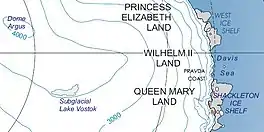 Kaiser Wilhelm II Land | |
 Location of Burton Island Glacier in Antarctica | |
| Type | channel |
| Location | Kaiser Wilhelm II Land |
| Coordinates | 66°49′S 90°20′E |
| Length | 9 nmi (17 km; 10 mi) |
| Width | 7 nmi (13 km; 8 mi) |
| Thickness | unknown |
| Terminus | Posadowsky Bay |
| Status | unknown |
References
- "Burton Island Glacier". Geographic Names Information System. United States Geological Survey, United States Department of the Interior. Retrieved October 8, 2011.
- "Gna-GeographicNamesOfTheAntarctic1stEdition1981_djvu". p. 327. Retrieved October 8, 2011.
![]() This article incorporates public domain material from "Burton Island Glacier". Geographic Names Information System. United States Geological Survey.
This article incorporates public domain material from "Burton Island Glacier". Geographic Names Information System. United States Geological Survey.
| Types | |||||||
|---|---|---|---|---|---|---|---|
| Anatomy | |||||||
| Processes | |||||||
| Measurements | |||||||
| Volcanic relations | |||||||
| Landforms |
| ||||||
| |||||||
Glaciers of Kaiser Wilhelm II Land | |
|---|---|
This article is issued from Wikipedia. The text is licensed under Creative Commons - Attribution - Sharealike. Additional terms may apply for the media files.