Cao Bằng
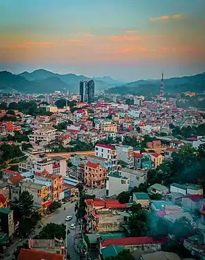
Cao Bằng ([kāːw ɓàŋ] ⓘ) is a city in northern Vietnam.[2] It is the capital and largest settlement of Cao Bằng Province. It is located on the bank of the Bằng Giang river, and is around 30 kilometres (19 mi) away from the border with China's Guangxi region. According to the 2019 census, Cao Bằng City has a population of 73,549 people.[1]
Cao Bằng
Thành phố Cao Bằng | |
|---|---|
| Cao Bằng City | |
 Streets in Cao Bằng city | |
 Cao Bằng Location of in Vietnam | |
| Coordinates: 22°40′00″N 106°15′30″E | |
| Country | |
| Province | Cao Bằng |
| Area | |
| • Total | 107.6281 km2 (41.5554 sq mi) |
| Population (2019)[1] | |
| • Total | 73,549 |
| • Density | 680/km2 (1,800/sq mi) |
| Time zone | UTC+7 (ICT) |
| Climate | Cwa |
History
The area, Cao Bằng (高平; 'high plateau'), was the stronghold of the last years of the Mạc dynasty after their 1592 defeat at the hands of the Trịnh lords. During the 19th century the area was resistant to the Nguyễn government.[3]
The city is also known for the Battle of Cao Bằng, the first major decisive victory of the Việt Minh against the French Army.[4]
During the sino-vietnamese war Cao Bằng fell for a limited time in chinese hands.
Climate
| Climate data for Cao Bằng | |||||||||||||
|---|---|---|---|---|---|---|---|---|---|---|---|---|---|
| Month | Jan | Feb | Mar | Apr | May | Jun | Jul | Aug | Sep | Oct | Nov | Dec | Year |
| Record high °C (°F) | 32.3 (90.1) |
35.9 (96.6) |
37.1 (98.8) |
39.5 (103.1) |
40.6 (105.1) |
39.6 (103.3) |
38.7 (101.7) |
39.1 (102.4) |
37.8 (100.0) |
36.9 (98.4) |
34.4 (93.9) |
32.3 (90.1) |
40.6 (105.1) |
| Average high °C (°F) | 18.4 (65.1) |
20.0 (68.0) |
23.4 (74.1) |
27.9 (82.2) |
31.2 (88.2) |
32.2 (90.0) |
32.5 (90.5) |
32.3 (90.1) |
31.4 (88.5) |
28.5 (83.3) |
24.6 (76.3) |
20.8 (69.4) |
26.9 (80.4) |
| Daily mean °C (°F) | 13.8 (56.8) |
15.5 (59.9) |
18.9 (66.0) |
23.1 (73.6) |
25.9 (78.6) |
27.2 (81.0) |
27.2 (81.0) |
26.8 (80.2) |
25.5 (77.9) |
22.7 (72.9) |
18.7 (65.7) |
15.1 (59.2) |
21.7 (71.1) |
| Average low °C (°F) | 10.9 (51.6) |
12.7 (54.9) |
16.0 (60.8) |
19.8 (67.6) |
22.3 (72.1) |
23.8 (74.8) |
24.1 (75.4) |
23.6 (74.5) |
22.1 (71.8) |
19.3 (66.7) |
15.4 (59.7) |
11.6 (52.9) |
18.5 (65.3) |
| Record low °C (°F) | −0.9 (30.4) |
1.8 (35.2) |
3.1 (37.6) |
6.6 (43.9) |
13.7 (56.7) |
15.6 (60.1) |
18.2 (64.8) |
16.7 (62.1) |
14.2 (57.6) |
7.2 (45.0) |
3.6 (38.5) |
−1.3 (29.7) |
−1.3 (29.7) |
| Average precipitation mm (inches) | 29.4 (1.16) |
24.7 (0.97) |
47.5 (1.87) |
84.3 (3.32) |
194.7 (7.67) |
247.1 (9.73) |
257.8 (10.15) |
257.2 (10.13) |
138.3 (5.44) |
75.8 (2.98) |
45.4 (1.79) |
25.1 (0.99) |
1,427.2 (56.19) |
| Average rainy days | 8.5 | 8.5 | 9.8 | 11.3 | 14.8 | 17.0 | 18.3 | 18.0 | 12.2 | 9.4 | 7.3 | 6.3 | 141.4 |
| Average relative humidity (%) | 81.1 | 80.7 | 80.5 | 80.3 | 80.3 | 82.9 | 84.8 | 85.8 | 84.0 | 82.6 | 82.1 | 80.4 | 82.1 |
| Mean monthly sunshine hours | 63.9 | 65.1 | 76.8 | 117.9 | 161.7 | 152.9 | 173.3 | 179.7 | 166.0 | 136.1 | 116.6 | 106.4 | 1,516.5 |
| Source: Vietnam Institute for Building Science and Technology[5] | |||||||||||||
Gallery
 A corner of the Bằng river flowing through the center of Cao Bằng city
 President Hồ Chí Minh's monument square
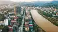 Kim Đồng Walking Street
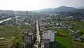 Road 3/10
 Hồ Chí Minh street lighting electrical project - Đề Thám ward and Hưng Đạo commune, Cao Bằng city
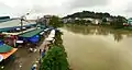 Đoạn chảy qua trung tâm thành phố Cao Bằng
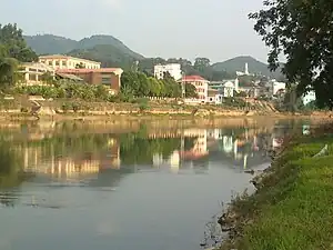 Sông Bằng Giang, đoạn chảy qua thành phố Cao Bằng
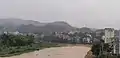 Bằng Giang river, section flowing through Cao Bằng city
References
- General Statistics Office of Vietnam (2019). "Completed Results of the 2019 Viet Nam Population and Housing Census" (PDF). Statistical Publishing House (Vietnam). ISBN 978-604-75-1532-5.
- http://baodientu.chinhphu.vn/Home/Thanh-lap-thanh-pho-Cao-Bang/20129/149871.vgp
- Bradley Camp Davis, States of banditry: The Nguyen government, bandit rule, and the ... University of Washington - 2008 Page 345 "..much of Lạng Son and Cao Bằng until his death in 1890. His organization, Which connected the aims of the Cần Vương with the tactics of borderlands banditry, Survived him."
- "UQAM | Guerre d'Indochine | CAO BẰNG, BATTLE OF". indochine.uqam.ca. Retrieved 2018-11-16.
- "Vietnam Institute for Building Science and Technology" (PDF).
| Bắc Giang province | 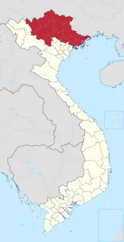 | |
|---|---|---|
| Bắc Kạn province | ||
| Cao Bằng province | ||
| Hà Giang province | ||
| Lạng Sơn province | ||
| Phú Thọ province | ||
| Quảng Ninh province |
| |
| Thái Nguyên province | ||
| Tuyên Quang province | ||
※ denotes provincial seat. | ||