Sør-Varanger
Sør-Varanger (Northern Sami: Máttá-Várjjat, Kven: Etelä-Varenki, Finnish: Etelä-Varanki, Russian: Сёр-Вара́нгер/Syor-Varánger)[4] is a municipality in Troms og Finnmark county, Norway. The administrative centre of the municipality is the town of Kirkenes. Other settlements in the municipality include the villages of Bjørnevatn, Bugøynes, Elvenes, Grense Jakobselv, Hesseng, Jakobsnes, Neiden, and Sandnes. Located west of the Norway–Russia border, Sør-Varanger is the only Norwegian municipality that shares a land border with Russia, with the only legal border crossing at Storskog.
Sør-Varanger kommune
Mátta-Várjjaga gielda Etelä-Varengin komuuni | |
|---|---|
 | |
 Flag  Troms og Finnmark within Norway | |
 Sør-Varanger within Troms og Finnmark | |
| Coordinates: 69°43′43″N 30°02′30″E | |
| Country | Norway |
| County | Troms og Finnmark |
| District | Øst-Finnmark |
| Established | 1 Jul 1858 |
| • Preceded by | Vadsø Municipality |
| Administrative centre | Kirkenes |
| Government | |
| • Mayor (2021) | Lena Norum Bergeng[1] (Ap) |
| Area | |
| • Total | 3,971.42 km2 (1,533.37 sq mi) |
| • Land | 3,458.84 km2 (1,335.47 sq mi) |
| • Water | 512.58 km2 (197.91 sq mi) 12.9% |
| • Rank | #6 in Norway |
| Population (2022) | |
| • Total | 9,925 |
| • Rank | #112 in Norway |
| • Density | 2.9/km2 (8/sq mi) |
| • Change (10 years) | |
| Demonym | Varangværing[2] |
| Official language | |
| • Norwegian form | Bokmål |
| Time zone | UTC+01:00 (CET) |
| • Summer (DST) | UTC+02:00 (CEST) |
| ISO 3166 code | NO-5444 |
| Website | Official website |
The 3,971-square-kilometre (1,533 sq mi) municipality is the 6th largest by area out of the 356 municipalities in Norway. Sør-Varanger is the 112th most populous municipality in Norway with a population of 9,925. The municipality's population density is 2.9 inhabitants per square kilometre (7.5/sq mi) and its population has increased by 0.7% over the previous 10-year period.[5][6]
Name
The meaning of the name Sør-Varanger comes from the name of the large Varangerfjorden (Old Norse: Ver(j)angr) on the northern shore of the municipality. The first part is ver meaning "fishing village" and the last part is angr which means "fjord". It was first probably used for the narrow fjord on the inside of Angsnes which now is called "Meskfjorden" and leads into Varangerbotn. Sør means "south" in Norwegian. Prior to 1918, the name was spelled Sydvaranger (also meaning "South Varanger"). Before 1964, there also was a municipality named Nord-Varanger, located north of the Varangerfjorden, covering most of present-day Vadsø municipality.[7]
History
Prehistoric labyrinth constructions at Holmengrå, were possibly used for religious purposes.
The original inhabitants of the area are the Skolt Sami. This Sami group migrated between coast and inland in present Norwegian, Finnish, and Russian territory long before any borders existed. In the 16th century, they were converted to the Russian Orthodox faith, and still today the chapel of Saint George at Neiden, dating from 1565, is a reminder of eastern influence.
Sør-Varanger became Norwegian in 1826, after having been [part of] a Russian-Norwegian fellesdistrikt - a district shared between two countries - that had a small Eastern Sami population group that was under Russian jurisdiction.[8] In 1826, the previously disputed areas were divided between Norway and Russia, causing great difficulties for the Sami. The Norwegian state also invited Norwegian settlers to come to the area, building Lutheran churches to counterbalance the Orthodox heritage, notably the King Oscar II Chapel, located immediately west of the Russian border. The historic border crossing station was at Skafferhullet (which was replaced with the present day station at Storskog).
The King Oscar II Chapel in Grense Jakobselv on the Russian border was built in 1869 to mark the border.
During the 19th century, Finnish settlers (Kven) arrived to the valleys, and since 1906, Norwegians came in large numbers because of the iron mining starting up near Kirkenes. After the Treaty of Tartu the area of Petsamo was ceded to Finland, and Sør-Varanger (and Norway) no longer bordered Russia, until Finland had to cede it back to the Soviet Union in 1944.
In 1906, the Sydvaranger company opened the Bjørnevatn Mine at Bjørnevatn and four years later the mine was connected to the port in Kirkenes by Kirkenes–Bjørnevatn Line, the world's most northern railway. The mine was closed in 1996, but re-opened in 2009.
In October 1944, Soviet forces chased Nazi-Germany's forces out of the municipality; some inhabitants were living in tunnels (outside Kirkenes) used for the mining industry, when the Soviet forces arrived; at the time Kirkenes was under intense bombing from aircraft.[9]
In a 1944 report to Norway's prime minister in exile, a Norwegian government official (embedsmann ) in Finnmark—Thore Boye—said that Norwegian soldiers had [crop-] cut (snauklippet) "25 young girls—some of them married" who had been pointed out by local men, as having had relations with German soldiers".[10]
Establishment of municipality
The municipality of Sør-Varanger was established on 1 July 1858 when the southern district of the municipality of Vadsø (population: 1,171) was separated to form the new municipality. The borders of the municipality have not changed since that time.[11]
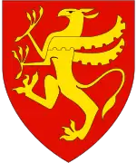
Coat of arms
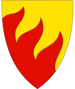
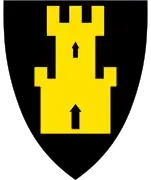
The coat of arms was granted on 16 April 1982. The official blazon is "Per bend rayonny Or and gules" (Norwegian: Skrådelt av gult og rødt ved tretunget flammesnitt). This means the arms have a field (background) with a diagonal line in the shape of flames. Above the line, the field has a tincture of Or which means it is commonly colored yellow, but if it is made out of metal, then gold is used. Below the line, the field has a tincture of gules (red). The arms show three flames along the division of the field. The division of the shield symbolizes the importance of the number three: The three main sources of income are agriculture, mining, and fishing; the municipality also has three main rivers (Neiden, Pasvikelva, and Jakobselva) that form the borders of Norway, Russia, and Finland; and there are three cultures in the municipality: Norwegians, Finns, and Sami. The arms were designed by Sissel Sildnes.[12][13][14]
Geography
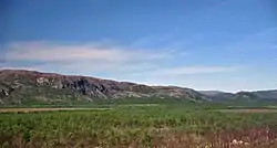
Sør-Varanger is a vast area of about 3,700 square kilometres (1,429 sq mi), situated between Finland and Russia. Most of the area is low-lying forest of pine and birch, with barren sections facing the Barents Sea.
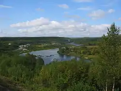
The Varangerfjorden runs along the northern part of the municipality and the Bøkfjorden runs north–south cutting into the municipality and flowing into the Varangerfjorden. The large island of Skogerøya lies on the west side of the Bøkfjorden. Skogerøytoppen is the tallest mountain on Skogerøya. The Bøkfjord Lighthouse lies along the mouth of the Bøkfjorden.
The municipal centre of Sør-Varanger is the town of Kirkenes, located on a peninsula in the Bøkfjorden. Other settlements include Bugøynes, Neiden, and little hamlets along the river of Pasvikelva. The local airport is called Kirkenes Airport, Høybuktmoen which is also a military camp. The Garrison of Sør-Varanger (GSV) is based at Høybuktmoen.
The flora of the area is a part of the Russian and Siberian taiga, including a few hundred spruce trees of the Russian variety. Bears also inhabit the upper valley, notably in the Øvre Pasvik National Park, Øvre Pasvik Landscape Protection Area, and Pasvik Nature Reserve.
Lakes include Ellenvatnet, Gardsjøen, Garsjøen, Klistervatnet, and Ødevatnet. The fjords include Korsfjorden.[15]
Climate
Sør-Varanger has a boreal climate (subarctic) with long, cold winters. Summers are short, but can sometimes see warm temperatures.
| Climate data for Kirkenes Airport 1991-2020 (89 m, extremes 1957-2020) | |||||||||||||
|---|---|---|---|---|---|---|---|---|---|---|---|---|---|
| Month | Jan | Feb | Mar | Apr | May | Jun | Jul | Aug | Sep | Oct | Nov | Dec | Year |
| Record high °C (°F) | 5.3 (41.5) |
7.3 (45.1) |
6.1 (43.0) |
14.4 (57.9) |
28.8 (83.8) |
31.6 (88.9) |
32.7 (90.9) |
30.7 (87.3) |
22.2 (72.0) |
13.6 (56.5) |
8.8 (47.8) |
7 (45) |
32.7 (90.9) |
| Average high °C (°F) | −6.8 (19.8) |
−6.8 (19.8) |
−2.9 (26.8) |
1.7 (35.1) |
7.2 (45.0) |
12.2 (54.0) |
16.2 (61.2) |
14.7 (58.5) |
10.1 (50.2) |
3 (37) |
−2.2 (28.0) |
−4.3 (24.3) |
3.5 (38.3) |
| Daily mean °C (°F) | −10.1 (13.8) |
−9.9 (14.2) |
−5.6 (21.9) |
−0.8 (30.6) |
4.3 (39.7) |
8.7 (47.7) |
12.4 (54.3) |
11.3 (52.3) |
7.3 (45.1) |
1.2 (34.2) |
−4.4 (24.1) |
−7.3 (18.9) |
0.6 (33.1) |
| Average low °C (°F) | −13.2 (8.2) |
−13 (9) |
−9.1 (15.6) |
−4.2 (24.4) |
1.2 (34.2) |
5.6 (42.1) |
9.2 (48.6) |
8.3 (46.9) |
4.8 (40.6) |
−0.8 (30.6) |
−6.9 (19.6) |
−10.2 (13.6) |
−2.4 (27.8) |
| Record low °C (°F) | −41.8 (−43.2) |
−38.9 (−38.0) |
−29.8 (−21.6) |
−20.9 (−5.6) |
−13.6 (7.5) |
−2.5 (27.5) |
2.4 (36.3) |
−1.5 (29.3) |
−5.9 (21.4) |
−21.7 (−7.1) |
−27.5 (−17.5) |
−34 (−29) |
−41.8 (−43.2) |
| Average precipitation mm (inches) | 31.3 (1.23) |
30 (1.2) |
28.7 (1.13) |
26.9 (1.06) |
26.8 (1.06) |
49.2 (1.94) |
56.2 (2.21) |
55.4 (2.18) |
37.9 (1.49) |
43.7 (1.72) |
36.8 (1.45) |
32.5 (1.28) |
458.8 (18.06) |
| Average precipitation days (≥ 1.0 mm) | 9 | 7 | 6 | 6 | 6 | 7 | 9.0 | 9 | 7 | 10 | 9 | 8 | 93 |
| Source 1: yr.no/statistics Kirkenes Airport [16] | |||||||||||||
| Source 2: Météo Climat [17] | |||||||||||||
| Climate data for Kirkenes Airport, Høybuktmoen 1961-90 | |||||||||||||
|---|---|---|---|---|---|---|---|---|---|---|---|---|---|
| Month | Jan | Feb | Mar | Apr | May | Jun | Jul | Aug | Sep | Oct | Nov | Dec | Year |
| Average high °C (°F) | −8.2 (17.2) |
−7.8 (18.0) |
−3.8 (25.2) |
0.6 (33.1) |
5.7 (42.3) |
12.5 (54.5) |
16.1 (61.0) |
13.9 (57.0) |
8.8 (47.8) |
2.4 (36.3) |
−2.8 (27.0) |
−5.9 (21.4) |
2.6 (36.7) |
| Daily mean °C (°F) | −11.8 (10.8) |
−11.3 (11.7) |
−7.4 (18.7) |
−2.4 (27.7) |
3.0 (37.4) |
8.5 (47.3) |
12.1 (53.8) |
10.5 (50.9) |
6.2 (43.2) |
0.4 (32.7) |
−5.5 (22.1) |
−9.7 (14.5) |
−0.6 (30.9) |
| Average low °C (°F) | −16.2 (2.8) |
−15.1 (4.8) |
−10.8 (12.6) |
−5.7 (21.7) |
0.0 (32.0) |
5.2 (41.4) |
8.7 (47.7) |
7.5 (45.5) |
3.6 (38.5) |
−1.9 (28.6) |
−8.7 (16.3) |
−13.4 (7.9) |
−3.9 (25.0) |
| Average precipitation mm (inches) | 32 (1.3) |
23 (0.9) |
21 (0.8) |
20 (0.8) |
23 (0.9) |
41 (1.6) |
60 (2.4) |
62 (2.4) |
47 (1.9) |
35 (1.4) |
33 (1.3) |
33 (1.3) |
430 (16.9) |
| Average precipitation days (≥ 1 mm) | 8.5 | 6.5 | 6.0 | 6.2 | 6.0 | 8.2 | 8.9 | 10.5 | 9.8 | 9.5 | 8.6 | 9.0 | 97.7 |
| Source: Norwegian Meteorological Institute[18] | |||||||||||||
Economy
The service sector is one of the two most important industries related to the city of Kirkenes.[19] Kimek, a company for repair of boats and ships,[20] had around 80 employees until job losses of 30 (in Q2 2023);[21][22][23][24] the company is one of the largest employers in the municipality - alongside the municipality itself.
As of 2013, 2.8% of the work force in Sør-Varanger are employed in the primary sector.[25]
Cruise ships have in 2022, stopped using the port at Kirkenes; ship owners consider the port to be too close to the [Russian border or] Russia;[26] in 2022 the war between Russia and Ukraine escalated.
The mining company Sydvaranger went bankrupt in 2015 and its mining operations in the municipality does not have a timeframe for a restart (as of 2022), however there are 30 employees preparing for a possible restart;[27] the company was acquired by Tacora Resources Inc (an American corporation) in 2021.[28] In 2023, Grangex bought Sydvaranger Mining.[29][30]
Government
All municipalities in Norway, including Sør-Varanger, are responsible for primary education (through 10th grade), outpatient health services, senior citizen services, unemployment and other social services, zoning, economic development, and municipal roads. The municipality is governed by a municipal council of elected representatives, which in turn elect a mayor.[31] The municipality falls under the Øst-Finnmark District Court and the Hålogaland Court of Appeal.
Municipal council
The municipal council of Sør-Varanger is made up of 27 representatives that are elected to four year terms. The party breakdown of the council is as follows:
| Party Name (in Norwegian) | Number of representatives | |
|---|---|---|
| Labour Party (Arbeiderpartiet) | 7 | |
| Progress Party (Fremskrittspartiet) | 3 | |
| Conservative Party (Høyre) | 8 | |
| Red Party (Rødt) | 2 | |
| Centre Party (Senterpartiet) | 2 | |
| Socialist Left Party (Sosialistisk Venstreparti) | 3 | |
| Liberal Party (Venstre) | 0 | |
| Total number of members: | 25 | |
| Party Name (in Norwegian) | Number of representatives | |
|---|---|---|
| Labour Party (Arbeiderpartiet) | 11 | |
| Progress Party (Fremskrittspartiet) | 1 | |
| Green Party (Miljøpartiet De Grønne) | 1 | |
| Conservative Party (Høyre) | 4 | |
| Red Party (Rødt) | 1 | |
| Centre Party (Senterpartiet) | 6 | |
| Socialist Left Party (Sosialistisk Venstreparti) | 3 | |
| Total number of members: | 27 | |
| Party Name (in Norwegian) | Number of representatives | |
|---|---|---|
| Labour Party (Arbeiderpartiet) | 14 | |
| Progress Party (Fremskrittspartiet) | 2 | |
| Conservative Party (Høyre) | 4 | |
| Centre Party (Senterpartiet) | 5 | |
| Socialist Left Party (Sosialistisk Venstreparti) | 2 | |
| Total number of members: | 27 | |
| Party Name (in Norwegian) | Number of representatives | |
|---|---|---|
| Labour Party (Arbeiderpartiet) | 10 | |
| Progress Party (Fremskrittspartiet) | 2 | |
| Conservative Party (Høyre) | 5 | |
| Centre Party (Senterpartiet) | 5 | |
| Socialist Left Party (Sosialistisk Venstreparti) | 2 | |
| Liberal Party (Venstre) | 1 | |
| Total number of members: | 25 | |
| Party Name (in Norwegian) | Number of representatives | |
|---|---|---|
| Labour Party (Arbeiderpartiet) | 11 | |
| Progress Party (Fremskrittspartiet) | 4 | |
| Conservative Party (Høyre) | 2 | |
| Centre Party (Senterpartiet) | 5 | |
| Socialist Left Party (Sosialistisk Venstreparti) | 2 | |
| Mátte Várjjat List (Mátte Várjjat Listu) | 1 | |
| Total number of members: | 25 | |
| Party Name (in Norwegian) | Number of representatives | |
|---|---|---|
| Labour Party (Arbeiderpartiet) | 7 | |
| Progress Party (Fremskrittspartiet) | 4 | |
| Conservative Party (Høyre) | 4 | |
| Centre Party (Senterpartiet) | 3 | |
| Socialist Left Party (Sosialistisk Venstreparti) | 5 | |
| Mátte Várjjat List (Mátte Várjjat Listu) | 2 | |
| Total number of members: | 25 | |
| Party Name (in Norwegian) | Number of representatives | |
|---|---|---|
| Labour Party (Arbeiderpartiet) | 14 | |
| Conservative Party (Høyre) | 9 | |
| Centre Party (Senterpartiet) | 3 | |
| Socialist Left Party (Sosialistisk Venstreparti) | 3 | |
| Liberal Party (Venstre) | 1 | |
| Mátte Várjjat List (Mátte Várjjat Listu) | 2 | |
| Total number of members: | 31 | |
| Party Name (in Norwegian) | Number of representatives | |
|---|---|---|
| Labour Party (Arbeiderpartiet) | 17 | |
| Conservative Party (Høyre) | 8 | |
| Centre Party (Senterpartiet) | 6 | |
| Socialist Left Party (Sosialistisk Venstreparti) | 4 | |
| Liberal Party (Venstre) | 2 | |
| Total number of members: | 37 | |
| Party Name (in Norwegian) | Number of representatives | |
|---|---|---|
| Labour Party (Arbeiderpartiet) | 16 | |
| Conservative Party (Høyre) | 9 | |
| Centre Party (Senterpartiet) | 3 | |
| Socialist Left Party (Sosialistisk Venstreparti) | 9 | |
| Total number of members: | 37 | |
| Party Name (in Norwegian) | Number of representatives | |
|---|---|---|
| Labour Party (Arbeiderpartiet) | 19 | |
| Progress Party (Fremskrittspartiet) | 2 | |
| Conservative Party (Høyre) | 9 | |
| Christian Democratic Party (Kristelig Folkeparti) | 1 | |
| Red Electoral Alliance (Rød Valgallianse) | 1 | |
| Centre Party (Senterpartiet) | 1 | |
| Socialist Left Party (Sosialistisk Venstreparti) | 4 | |
| Total number of members: | 37 | |
| Party Name (in Norwegian) | Number of representatives | |
|---|---|---|
| Labour Party (Arbeiderpartiet) | 21 | |
| Conservative Party (Høyre) | 10 | |
| Christian Democratic Party (Kristelig Folkeparti) | 1 | |
| Red Electoral Alliance (Rød Valgallianse) | 1 | |
| Centre Party (Senterpartiet) | 1 | |
| Socialist Left Party (Sosialistisk Venstreparti) | 3 | |
| Total number of members: | 37 | |
| Party Name (in Norwegian) | Number of representatives | |
|---|---|---|
| Labour Party (Arbeiderpartiet) | 18 | |
| Conservative Party (Høyre) | 12 | |
| Christian Democratic Party (Kristelig Folkeparti) | 1 | |
| Centre Party (Senterpartiet) | 2 | |
| Socialist Left Party (Sosialistisk Venstreparti) | 4 | |
| Total number of members: | 37 | |
| Party Name (in Norwegian) | Number of representatives | |
|---|---|---|
| Labour Party (Arbeiderpartiet) | 19 | |
| Conservative Party (Høyre) | 8 | |
| Christian Democratic Party (Kristelig Folkeparti) | 2 | |
| Centre Party (Senterpartiet) | 2 | |
| Socialist Left Party (Sosialistisk Venstreparti) | 5 | |
| Liberal Party (Venstre) | 1 | |
| Total number of members: | 37 | |
| Party Name (in Norwegian) | Number of representatives | |
|---|---|---|
| Labour Party (Arbeiderpartiet) | 20 | |
| Conservative Party (Høyre) | 8 | |
| Christian Democratic Party (Kristelig Folkeparti) | 1 | |
| Centre Party (Senterpartiet) | 2 | |
| Liberal Party (Venstre) | 1 | |
| Socialist common list (Venstresosialistiske felleslister) | 5 | |
| Total number of members: | 37 | |
| Party Name (in Norwegian) | Number of representatives | |
|---|---|---|
| Labour Party (Arbeiderpartiet) | 20 | |
| Conservative Party (Høyre) | 8 | |
| Communist Party (Kommunistiske Parti) | 2 | |
| Christian Democratic Party (Kristelig Folkeparti) | 1 | |
| Centre Party (Senterpartiet) | 1 | |
| Socialist People's Party (Sosialistisk Folkeparti) | 2 | |
| Liberal Party (Venstre) | 3 | |
| Total number of members: | 37 | |
| Party Name (in Norwegian) | Number of representatives | |
|---|---|---|
| Labour Party (Arbeiderpartiet) | 20 | |
| Conservative Party (Høyre) | 9 | |
| Communist Party (Kommunistiske Parti) | 4 | |
| Christian Democratic Party (Kristelig Folkeparti) | 1 | |
| Socialist People's Party (Sosialistisk Folkeparti) | 1 | |
| Liberal Party (Venstre) | 2 | |
| Total number of members: | 37 | |
| Party Name (in Norwegian) | Number of representatives | |
|---|---|---|
| Labour Party (Arbeiderpartiet) | 18 | |
| Conservative Party (Høyre) | 6 | |
| Communist Party (Kommunistiske Parti) | 6 | |
| Christian Democratic Party (Kristelig Folkeparti) | 1 | |
| Liberal Party (Venstre) | 1 | |
| Local List(s) (Lokale lister) | 1 | |
| Total number of members: | 33 | |
| Party Name (in Norwegian) | Number of representatives | |
|---|---|---|
| Labour Party (Arbeiderpartiet) | 16 | |
| Conservative Party (Høyre) | 5 | |
| Communist Party (Kommunistiske Parti) | 7 | |
| Christian Democratic Party (Kristelig Folkeparti) | 1 | |
| Liberal Party (Venstre) | 2 | |
| Local List(s) (Lokale lister) | 2 | |
| Total number of members: | 33 | |
| Party Name (in Norwegian) | Number of representatives | |
|---|---|---|
| Labour Party (Arbeiderpartiet) | 11 | |
| Conservative Party (Høyre) | 4 | |
| Communist Party (Kommunistiske Parti) | 7 | |
| Liberal Party (Venstre) | 1 | |
| List of workers, fishermen, and small farmholders (Arbeidere, fiskere, småbrukere liste) | 3 | |
| Local List(s) (Lokale lister) | 2 | |
| Total number of members: | 28 | |
| Party Name (in Norwegian) | Number of representatives | |
|---|---|---|
| Labour Party (Arbeiderpartiet) | 12 | |
| Communist Party (Kommunistiske Parti) | 8 | |
| Joint List(s) of Non-Socialist Parties (Borgerlige Felleslister) | 8 | |
| Total number of members: | 28 | |
| Party Name (in Norwegian) | Number of representatives | |
|---|---|---|
| Labour Party (Arbeiderpartiet) | 12 | |
| Communist Party (Kommunistiske Parti) | 10 | |
| Local List(s) (Lokale lister) | 6 | |
| Total number of members: | 28 | |
| Party Name (in Norwegian) | Number of representatives | |
|---|---|---|
| Labour Party (Arbeiderpartiet) | 12 | |
| Communist Party (Kommunistiske Parti) | 2 | |
| List of workers, fishermen, and small farmholders (Arbeidere, fiskere, småbrukere liste) | 5 | |
| Joint List(s) of Non-Socialist Parties (Borgerlige Felleslister) | 3 | |
| Local List(s) (Lokale lister) | 6 | |
| Total number of members: | 28 | |
| Note: Due to the German occupation of Norway during World War II, no elections were held for new municipal councils until after the war ended in 1945. | ||
Mayors
The mayors of Sør-Varanger:[51]
- 1858-1860: Hans Kirkgaard
- 1861-1864: Christian Taftezon
- 1865-1868: Hans Figenschau
- 1869-1872: Johannes Belsheim
- 1873-1886: Anders Tokle
- 1887-1890: Edvard Bakken
- 1891-1894: Anders Tokle (V)
- 1895-1900: Emil Stang Lund (H)
- 1900-1904: Johannes Haaheim (V)
- 1905-1910: Andreas Bredal Wessel (Ap)
- 1911-1916: Mads Le Maire (LL)
- 1917-1919: Andreas Bergerud (LL)
- 1920-1922: Johan Hølvold (Ap)
- 1923-1925: Bjarne Sårheim (V)
- 1926-1928: Johan Hølvold (Ap)
- 1929-1931: Axel Borgen (V)
- 1923-1937: Sigurd Dørum (V)
- 1938-1940: Sverre Dølvik (Ap)
- 1944-1945: Sverre Dølvik (Ap)
- 1946-1947: Gotfred Johan Hølvold (NKP)
- 1948-1955: Harry Klippenvåg (Ap)
- 1950-1955: Hilmar Isaksen (Ap)
- 1956-1962: William Mikkelsen (Ap)
- 1962-1980: Arnt Isaksen (Ap)
- 1980-1982: Alfon Jerijärvi (Ap)
- 1982-1989: Nils-Edvard Olsen (Ap)
- 1990-1991: Halvard Kvamsdal (Ap)
- 1991-2003: Alfon Jerijärvi (Ap)
- 2003-2007: Tone Hatle (H)
- 2007-2011: Linda Beate Randal (Ap)
- 2011-2015: Cecilie Hansen (Sp)
- 2015-2021: Rune Rafaelsen (Ap)
- 2021-present: Lena Norum Bergeng (Ap)
Transportation
Kirkenes Airport, Høybuktmoen is operated by the state-owned Avinor and serves as the main primary airport for eastern Finnmark county. Located 10 kilometers (6.2 mi) west of Kirkenes, at Høybuktmoen,[52] the airport has a 2,115-meter (6,939 ft)[53] long runway which allows Scandinavian Airlines and Norwegian Air Shuttle to operate direct flights to Oslo. In addition Widerøe uses the airport as a hub to regional airports throughout Finnmark.[54]
The Kirkenes–Bjørnevatn Line is a 8.5-kilometer (5.3 mi) railway, until 2010 the world's northernmost, which runs between Kirkenes and Bjørnevatn;[55]
The European route E6 highway has its northern endpoint in the town of Kirkenes. This highway heads west and then south to the rest of Norway. The European route E105 highway has its northern endpoint in the village of Hesseng, just south of Kirkenes. That highway heads south into Russia through the Storskog border crossing, the only legal public crossing on the Norway-Russia border.
Religion
Churches
The Church of Norway has one parish (sokn) within the municipality of Sør-Varanger. It is part of the Varanger prosti (deanery) in the Diocese of Nord-Hålogaland.
| Parish (sokn) | Church name | Location of the church | Year built |
|---|---|---|---|
| Sør-Varanger | Bugøynes Chapel | Bugøynes | 1989 |
| Kirkenes Church | Kirkenes | 1959 | |
| King Oscar II Chapel | Grense Jakobselv | 1869 | |
| Neiden Chapel | Neiden | 1902 | |
| Svanvik Church | Svanvik (in the Pasvikdalen valley) | 1934 |
Archaeology
In 2015 rock carvings, estimatedly dated to 4200–5200 B.C. were found at Tømmerneset on Gamneset, several kilometers outside Kirkenes.[56][57] The carvings were discovered along an old path used by reindeers—between two crags—by an archaeologist traveling between existing excavation sites at Gamneset.[56] (A planned oil terminal will expectedly shut out the general public, from the site of the carvings.[58])
Leisure
Popular leisure activities include salmon fishing in one of the numerous rivers, hunting for moose and grouse, and snowmobile driving. Many inhabitants also own and frequently use a cabin located in more remote parts of the municipality.
Notable people

- Kathrine Bugge (1877–1951) an educator, cultural worker and politician, brought up in Jarfjord
- John Savio (1902 in Bugøyfjord - 1938) an artist of Sami and Kven descent, made woodcuts
- Osvald Harjo (1910–1993) a resistance member in WWII and a prisoner in Soviet Gulag camps for over a decade
- Alfred Henningsen (1918 in Sør-Varanger – 2012) a military officer, spy and politician
- Gudmund Grytøyr (born 1920 in Sør-Varanger - 2001) a sailor, laborer in industry and forestry, a farmer and politician
- Annemarie Lorentzen (1921 in Sør-Varanger – 2008) a politician and Norwegian ambassador to Iceland 1978 to 1985
- Aino Hivand (born 1947 in Bugøyfjord) Norwegian-Sami visual artist and children's book writer
- Helga Pedersen (born 1973 in Sør-Varanger) a politician, former Minister and member of the Storting; brought up in Vestertana
- Pavel Zakharov (born 2001 in Sør-Varanger) a Russian college basketball player
- and
Gallery
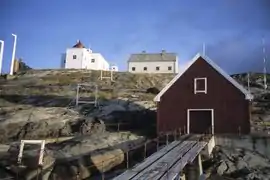 Bøkfjord lighthouse in Sør Varanger
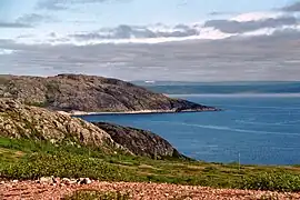 Jarfjord, seen from N886, Sør-Varanger
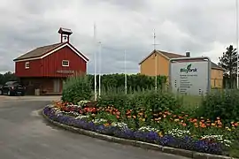 Svanhovd miljøsenter, Nasjonalparksenter, Bioforsk
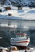 Hilde Kristin i vinteropplag
References
- "NY ordfører i Sør-Varanger". 28 April 2021.
- "Navn på steder og personer: Innbyggjarnamn" (in Norwegian). Språkrådet.
- "Forskrift om målvedtak i kommunar og fylkeskommunar" (in Norwegian). Lovdata.no.
- Russian pronunciation: [ˌsʲɵr vɐˈranɡʲɪr]
- Statistisk sentralbyrå. "Table: 06913: Population 1 January and population changes during the calendar year (M)" (in Norwegian).
- Statistisk sentralbyrå. "09280: Area of land and fresh water (km²) (M)" (in Norwegian).
- Rygh, Oluf (1924). Norske gaardnavne: Finmarkens amt (in Norwegian) (18 ed.). Kristiania, Norge: W. C. Fabritius & sønners bogtrikkeri. p. 288.
- https://forskning.no/partner-etnisitet-sosialantropologi/forvirring-om-hvem-er-kven/978810. Forskning.no. Retrieved 9 May 2022. "Sør-Varanger ble norsk land i 1826 etter å ha vært et norsk-russisk fellesdistrikt med en liten østsamisk befolkning under russisk jurisdiksjon."
- https://www.aftenposten.no/amagasinet/i/rll5al/de-upassende-minnene. Aftenposten.no. Retrieved 2022-11-06
- "Skamklipt av norske soldater - NRK Dokumentar". nrk.no. 13 September 2013. Retrieved 21 August 2016.
- Jukvam, Dag (1999). "Historisk oversikt over endringer i kommune- og fylkesinndelingen" (PDF) (in Norwegian). Statistisk sentralbyrå.
- "Civic heraldry of Norway - Norske Kommunevåpen". Heraldry of the World. Retrieved 23 January 2023.
- "Sor-Varanger, Finmark". Flags of the World. Retrieved 23 January 2023.
- "Godkjenning av våpen og flagg". Lovdata.no (in Norwegian). Norges kommunal- og arbeidsdepartementet. 20 July 1982. Retrieved 23 January 2023.
- Mener Miljøverndepartementet lar seg presse av oljenæringen [Of the opinion that the Department of Environmental Protection lets itself coerce by the oil industry]
- "yr.no/ Norwegian Meteorological Institute (mean, precipitation)". Retrieved 31 December 2021.
- "Météo Climat stats for Kirkenes". Météo Climat. Retrieved 31 December 2021.
- "eKlima Web Portal". Norwegian Meteorological Institute. Archived from the original on 14 June 2004.
- "Sør-Varanger – Store norske leksikon". Snl.no. Retrieved 13 August 2022.
- https://snl.no/Kirkenes "I Kirkenes ligger skipsindustri; Kimek AS reparerer russiske båter." Accessed 7 March 2021
- https://www.nettavisen.no/okonomi/inntil-30-ansatte-mister-jobben-ved-skipsverftet-kimek-i-kirkenes/s/5-95-1161125. Nettavisen. Retrieved 2023-06-17
- https://www.nrk.no/tromsogfinnmark/regjeringen-skjerper-sanksjonene-mot-russland-1.16407491. NRK.no. Retrieved 2023-05-12
- https://www.nettavisen.no/nyheter/kirkenes-rammes-hardt-av-sanksjonene-det-som-skjer-na-kan-vare/s/12-95-3424273404. Nettavisen. Retrieved 9 May 2022
- "Havarert tråler stenger kaia – russisk rederi skylder på verftet i Kirkenes". 6 April 2021.
- https://www.statsforvalteren.no/siteassets/utgatt/fm-finnmark/dokument-fmfi/kommunal-styring/kommunereformen/endelige-statusbilder/sor-varanger-kommune-statusbilde.pdf. P.10. "Arbeidsplasser - sysselsatte som arbeider i Sør-Varanger [...] 2013 [...] Primærnæring [...] Totalt [...] 5720"
- https://e24.no/naeringsliv/i/g6m1B9/cruiseskip-dropper-kirkenes-for-naert-russland?referer=https%3A%2F%2Fwww.vg.no. E24 Næringsliv. Retrieved 22 May 2022
- https://www.dagsavisen.no/nyheter/2022/12/07/den-norske-gigantgruva-kan-fa-nytt-liv/. Dagsavisen.no. Retrieved 2022-12-08
- https://snl.no/Sydvaranger_-_gruveselskap. Store norske leksikon. Retrieved 19 June 2022
- "GRANGEX enters into an exclusivity agreement to acquire Sydvaranger Mining AS". 29 June 2023.
- https://www.nrk.no/tromsogfinnmark/svensk-gruveselskap-kjoper-sydvaranger-gruve-1.16465257. NRK.no. Retrieved 2023-06-29
- Hansen, Tore, ed. (12 May 2016). "kommunestyre". Store norske leksikon (in Norwegian). Kunnskapsforlaget. Retrieved 28 May 2018.
- "Tall for Norge: Kommunestyrevalg 2019 - Troms og Finnmark". Valg Direktoratet. Retrieved 23 October 2019.
- "Tall for Norge: Kommunestyrevalg 2019 - Troms og Finnmark". Valg Direktoratet. Retrieved 23 October 2019.
- "Table: 04813: Members of the local councils, by party/electoral list at the Municipal Council election (M)" (in Norwegian). Statistics Norway.
- "Tall for Norge: Kommunestyrevalg 2011 - Finnmark". Valg Direktoratet. Retrieved 23 October 2019.
- "Kommunestyrevalget 1995" (PDF) (in Norwegian). Oslo-Kongsvinger: Statistisk sentralbyrå. 1996. Retrieved 20 February 2020.
- "Kommunestyrevalget 1991" (PDF) (in Norwegian). Oslo-Kongsvinger: Statistisk sentralbyrå. 1993. Retrieved 20 February 2020.
- "Kommunestyrevalget 1987" (PDF) (in Norwegian). Oslo-Kongsvinger: Statistisk sentralbyrå. 1988. Retrieved 20 February 2020.
- "Kommunestyrevalget 1983" (PDF) (in Norwegian). Oslo-Kongsvinger: Statistisk sentralbyrå. 1984. Retrieved 20 February 2020.
- "Kommunestyrevalget 1979" (PDF) (in Norwegian). Oslo: Statistisk sentralbyrå. 1979. Retrieved 20 February 2020.
- "Kommunevalgene 1975" (PDF) (in Norwegian). Oslo: Statistisk sentralbyrå. 1977. Retrieved 16 March 2020.
- "Kommunevalgene 1972" (PDF) (in Norwegian). Oslo: Statistisk sentralbyrå. 1973. Retrieved 16 March 2020.
- "Kommunevalgene 1967" (PDF) (in Norwegian). Oslo: Statistisk sentralbyrå. 1967. Retrieved 16 March 2020.
- "Kommunevalgene 1963" (PDF) (in Norwegian). Oslo: Statistisk sentralbyrå. 1964. Retrieved 16 March 2020.
- "Kommunevalgene og Ordførervalgene 1959" (PDF) (in Norwegian). Oslo: Statistisk sentralbyrå. 1960. Retrieved 16 March 2020.
- "Kommunevalgene og Ordførervalgene 1955" (PDF) (in Norwegian). Oslo: Statistisk sentralbyrå. 1957. Retrieved 16 March 2020.
- "Kommunevalgene og Ordførervalgene 1951" (PDF) (in Norwegian). Oslo: Statistisk sentralbyrå. 1952. Retrieved 16 March 2020.
- "Kommunevalgene og Ordførervalgene 1947" (PDF) (in Norwegian). Oslo: Statistisk sentralbyrå. 1948. Retrieved 16 March 2020.
- "Kommunevalgene og Ordførervalgene 1945" (PDF) (in Norwegian). Oslo: Statistisk sentralbyrå. 1947. Retrieved 16 March 2020.
- "Kommunevalgene og Ordførervalgene 1937" (PDF) (in Norwegian). Oslo: Statistisk sentralbyrå. 1938. Retrieved 16 March 2020.
- "Ordførere i Sør-Varanger kommune 1858-2008". Sør-Varanger kommune (in Norwegian). Retrieved 21 February 2023.
- "To/from airport". Avinor. Archived from the original on 15 August 2012. Retrieved 26 August 2012.
- "ENKR – Kirkenes/Høybuktmoen" (PDF). Avinor. 8 March 2012. Archived from the original (PDF) on 1 February 2014. Retrieved 19 August 2012.
- "Flight Timetables". Avinor. Retrieved 26 August 2012.
- Bjerke, Thor; Jerijervi, Ørjan (2003). "Aktieselskabet Sydvarangers jernbane". Ottar (in Norwegian). Tromsø: University of Tromsø. 244: 32–39.
- "Oppdaget sensasjonelt helleristningsfelt i lunsjpausen - Aftenposten". aftenposten.no. Retrieved 21 August 2016.
- "Sensasjonelt helleristningsfunn i Varanger - NRK Finnmark - Lokale nyheter, TV og radio". nrk.no. 26 August 2015. Retrieved 21 August 2016.
- "Helleristningene i Varanger - Video | Tror ikke folk får se helleristningene". nrk.no. Retrieved 21 August 2016.
External links
- Municipal fact sheet from Statistics Norway (in Norwegian)
- Weather information for Sør-Varanger (in Norwegian)
- Tourist information: www.visitkirkenes.no
- Video of 2015 rock carvings find, Helleristningene i Varanger
Troms og Finnmark county, Norway | |||||||||
|---|---|---|---|---|---|---|---|---|---|
| |||||||||
 | Towns and cities |
|   | ||||||
| Municipalities |
| ||||||||