Delhi Territory
The Delhi Territory was an administrative region in British India which comprised present-day Delhi plus Bhiwani, Faridabad, Fatehabad, Gurgaon, Hisar, Jhajjar, Karnal, Nuh, Palwal, Panipat, Rewari, Rohtak, Sirsa, Sonipat and Yamunanagar districts of Haryana.
| Delhi Territory | |||||||||
|---|---|---|---|---|---|---|---|---|---|
| Territory of the British Empire in India | |||||||||
| 1803–1832 | |||||||||
.svg.png.webp) Flag | |||||||||
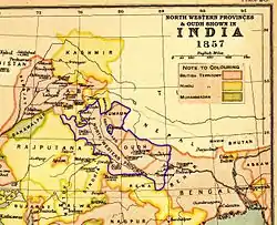 Delhi Territory as part of North-Western Provinces | |||||||||
| Capital | Delhi | ||||||||
| History | |||||||||
| History | |||||||||
• Established | 1803 | ||||||||
• Disestablished | 1832 | ||||||||
| |||||||||
| Today part of | Portions in Haryana Delhi | ||||||||
History

Until 1832, the Delhi Division was controlled by the Residency. Regulation V of that year, abolished the office of Resident and annexed the Delhi territory to the jurisdiction of the Sadr Board and Courts of Justice at Allahabad, which included the Commissioner of the Delhi territory and all officers acting under his control, ordinarily to "or form to the principles and spirit of the regulations" in their his control, ordinarily to administration.
After the Indian rebellion of 1857, the Delhi Division of the North-Western Provinces was transferred to the Punjab in 1858, and formed into the Delhi and Hissar divisions, which embraced the six districts of Ambala, Delhi, Gurgaon, Hissar, Karnal and Rohtak.[1]
Notes
- Douie, James McCrone (1899). Panjab Settlement Manual. Lahore: Civil and Military Gazette Press. Archived from the original on 10 October 2017. Retrieved 19 April 2010.
 This article incorporates text from this source, which is in the public domain.