Districts of British India
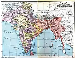
The Districts of British India were administrative units of the Government of the British Raj or Indian Empire. Districts were generally subdivisions of the provinces and divisions of British India[1]
| Colonial India | ||||||||||||||
|---|---|---|---|---|---|---|---|---|---|---|---|---|---|---|
 | ||||||||||||||
|
||||||||||||||
|
||||||||||||||
|
||||||||||||||
History
Districts, often known as zillas in vernacular, were established as subdivisions of the provinces (praanths in vernacular) and divisions of British India that were under one of the three Presidencies. [2]
Most of the districts that were created during the British Raj became Districts of India after the independence of India.
Historical districts
The following list includes only districts of British India that became extinguished or that saw major changes in their history:
Districts in the Madras Presidency
- Anantapur district
- Bellary district (including parts of Present-day Kurnool district)
- Chingleput District
- Coimbatore District (Madras Presidency)
- Cuddapah district
- Ganjam district (including present-day Gajapati district and parts of Srikakulam district)
- Godavari District
- Krishna district (including Guntur district)
- Kurnool district (including parts of present-day Prakasam district)
- Madura District (Madras Presidency)
- Malabar District
- Nellore district (including parts of present-day Prakasam and Tiruvallur districts)
- North Arcot
- Salem District
- South Arcot District
- South Canara
- Tanjore District
- Tinnevely District
- Trichinopoly District
- Vizagapatam district (including Vizianagaram district)
Districts in the Bengal Presidency
- Agra district
- Allahbad district
- Bogra District
- Bakerganj District
- Bardhaman district
- Bhagalpur district
- Birbhum district
- Bassein District
- Champaran District
- Chittagong District
- Calcutta district
- Cuttack district
- Dacca District
- Dinajpur District
- Darjeeling district
- Delhi district
- Faridpur district
- Garo Hills district
- Howrah district
- Hooghly district
- Jalpaiguri district
- Jessore District
- Jungle Mahals
- Jungle Terry
- Khasi and Jaintia Hills
- Khulna District
- Kamrup district
- Lushai Hills District
- Malda district
- Manbhum District
- Midnapore District
- Murshidabad district
- Mymensingh District
- Nadia district
- Naga Hills District
- Noakhali District
- Pabna District
- Purnia District
- Patna district
- 24 Paraganas District
- Rajshahi District
- Rangpur District
- Shahabad district
- Santhal Pargana District
- Singhbhum District
- Sylhet District
- Tipperah District
Districts in the Bombay Presidency
- East Khandesh
- Kaladgi District
- Khandesh District
- Upper Sind Frontier District
- West Khandesh
Other districts
- Bhilsa District
- Chanderi District
- Delhi District
- Ellichpur District
- Garhwal District
- Hazara District
- Isagarh District
- Kumaon District
- Lyallpur District
- Merwara District
- Montgomery District
- Muhamdi District
- Nimar District
- North Bareilly District
- Quetta-Pishin District
- Shahpur District
- Sironj District
- Thal-Chotiali
- Wun District
- Neemuch District
- Peshawar District
See also
References
- Imperial Gazetteer of India. Published under the authority of His Majesty's Secretary of State for India in Council. Oxford: Clarendon Press, 1907-1909
- Imperial Gazetteer of India, vol. V, 1908
This article is issued from Wikipedia. The text is licensed under Creative Commons - Attribution - Sharealike. Additional terms may apply for the media files.