Administrative divisions of British India
The Divisions of British India were administrative units of the Government of the British Raj or Indian Empire.[1]
| Colonial India | ||||||||||||||
|---|---|---|---|---|---|---|---|---|---|---|---|---|---|---|
 | ||||||||||||||
|
||||||||||||||
|
||||||||||||||
|
||||||||||||||

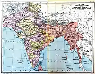
1909 British Indian Empire map as appeared in The Imperial Gazetteer of India
Divisions in Bengal
The seven Bengal Regulation Districts were named as 'divisions' in 1851:
- Jessore Division, area 14,853 sq mi, population 5,345,472 (1851)
- Bhagalpur Division area 26,464 sq mi, population 8,431,000
- Cuttack Division, area 12,664 sq mi, population 2,793,883
- British division
(Moorshedabad), area 17,556 sq mi, population 6,815,876
- Dacca Division, area 20,942 sq mi, population 4,055,800
- Patna Division, area 13,803 sq mi, population 7,000,000
- Chittagong Division, area 7,410 sq mi, population 2,406,950
Divisions of Eastern Bengal and Assam
The divisions of Eastern Bengal and Assam Province 1905—1912:
- Dacca Division
- Chittagong Division
- Rajshahi Division
- Assam Valley Division
- Surma Valley and Hill Districts Division
Divisions in Baroda
- Kadi Division
- Baroda Division
- Amreli Division
- Navsari Division
Divisions in Bombay
- Northern Division
- Southern Division
- Central Division
- Sind Division
Divisions in Burma
Divisions in Central India
Divisions of Hyderabad
- Aurangabad Division
- Gulbarga Division
- Gushanabad Division (Medak Division)
- Warangal Division
Divisions in Rajputana
- Western Rajputana States Residency
- Haraoti and Tonk Agency
- Mewar Residency
- Eastern Rajputana States Agency
- Kotah and Jhalawar Agency
Divisions in Agra
- Meerut Division
- Agra Division
- Bareilly Division
- Allahabad Division
- Benares Division
- Gorakhpur Division
- Kumaun Division
Divisions in Oudh
- Lucknow Division formerly also Sitapur Division
- Faizabad Division (Fyzabad Division)
Divisions in Punjab
- Lahore Division
- Rawalpindi Division
- Multan Division
- Ambala Division and Delhi Division until 1921
- Jalandhar Division
See also
References
- Imperial Gazetteer of India. Published under the authority of His Majesty's Secretary of State for India in Council. Oxford: Clarendon Press, 1907-1909
This article is issued from Wikipedia. The text is licensed under Creative Commons - Attribution - Sharealike. Additional terms may apply for the media files.