Dolní Novosedly
Dolní Novosedly is a municipality and village in Písek District in the South Bohemian Region of the Czech Republic. It has about 300 inhabitants.
Dolní Novosedly | |
|---|---|
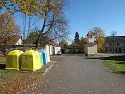 Centre of Dolní Novosedly | |
 Dolní Novosedly Location in the Czech Republic | |
| Coordinates: 49°19′45″N 14°11′46″E | |
| Country | |
| Region | South Bohemian |
| District | Písek |
| First mentioned | 1517 |
| Area | |
| • Total | 5.48 km2 (2.12 sq mi) |
| Elevation | 486 m (1,594 ft) |
| Population (2023-01-01)[1] | |
| • Total | 254 |
| • Density | 46/km2 (120/sq mi) |
| Time zone | UTC+1 (CET) |
| • Summer (DST) | UTC+2 (CEST) |
| Postal code | 397 01 |
| Website | www |
Administrative parts
Villages of Chrastiny and Horní Novosedly are administrative parts of Dolní Novosedly.
Geography
Dolní Novosedly is located about 4 kilometres (2 mi) northeast of Písek and 43 km (27 mi) northwest of České Budějovice. It lies in the Tábor Uplands. The highest point is the hill Mláka at 548 metres (1,798 ft) above sea level. The Podhorák pond is located in the municipality.
History
The first written mention of Dolní Novosedly is from 1517.[2]
Transport
The I/29 road from Písek to Tábor passes through the municipality.
Sights
In Dolní Novosedly is a chapel from the 19th century.[3]
References
- "Population of Municipalities – 1 January 2023". Czech Statistical Office. 2023-05-23.
- "Obec Dolní Novosedly" (in Czech). Obec Dolní Novosedly. Retrieved 2022-12-21.
- "Kaple návesní" (in Czech). National Heritage Institute. Retrieved 2022-12-21.
This article is issued from Wikipedia. The text is licensed under Creative Commons - Attribution - Sharealike. Additional terms may apply for the media files.