Záhoří (Písek District)
Záhoří is a municipality in Písek District in the South Bohemian Region of the Czech Republic. It has about 800 inhabitants.
Záhoří | |
|---|---|
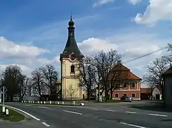 Church of Saint Michael | |
 Flag  Coat of arms | |
 Záhoří Location in the Czech Republic | |
| Coordinates: 49°20′59″N 14°12′50″E | |
| Country | |
| Region | South Bohemian |
| District | Písek |
| First mentioned | 1575 |
| Area | |
| • Total | 14.72 km2 (5.68 sq mi) |
| Elevation | 482 m (1,581 ft) |
| Population (2023-01-01)[1] | |
| • Total | 799 |
| • Density | 54/km2 (140/sq mi) |
| Time zone | UTC+1 (CET) |
| • Summer (DST) | UTC+2 (CEST) |
| Postal code | 398 18 |
| Website | www |
Administrative parts
The municipality is made up of villages of Dolní Záhoří, Horní Záhoří, Jamný, Kašina Hora, Svatonice and Třešně.
Geography
Záhoří is located about 6 kilometres (4 mi) northeast of Písek and 44 km (27 mi) northwest of České Budějovice. It lies in the Tábor Uplands. The highest point is the hill Na Lomech at 543 metres (1,781 ft) above sea level.
Economy
Most of the people are employed in Písek, smaller number of them in local agricultural business.
Transport
Záhoří is situated on the railway line from Písek to Tábor and on a bus line from Písek to Milevsko. The train station Záhoří is located in Svatonice part of Záhoří.
Sights
In Horní Záhoří there is the Church of Saint Michael. The first mention of the church is from 1351, but it was destroyed during the Thirty Years' War and completely rebuilt in 1639. Modifications were made in the 18th and 19th centuries.[2]
References
- "Population of Municipalities – 1 January 2023". Czech Statistical Office. 2023-05-23.
- "Kostel sv. Michaela" (in Czech). National Heritage Institute. Retrieved 2022-08-31.