Droué
Droué (French pronunciation: [dʁue]) is a commune in the Loir-et-Cher department of central France.[3]
Droué | |
|---|---|
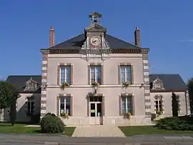 Town hall | |
 Coat of arms | |
Location of Droué | |
 Droué  Droué | |
| Coordinates: 48°02′29″N 1°04′38″E | |
| Country | France |
| Region | Centre-Val de Loire |
| Department | Loir-et-Cher |
| Arrondissement | Vendôme |
| Canton | Le Perche |
| Intercommunality | Perche et Haut Vendômois |
| Government | |
| • Mayor (2020–2026) | Catherine Monnier[1] |
| Area 1 | 24.04 km2 (9.28 sq mi) |
| Population | 1,013 |
| • Density | 42/km2 (110/sq mi) |
| Time zone | UTC+01:00 (CET) |
| • Summer (DST) | UTC+02:00 (CEST) |
| INSEE/Postal code | 41075 /41260 |
| Elevation | 143–214 m (469–702 ft) (avg. 158 m or 518 ft) |
| 1 French Land Register data, which excludes lakes, ponds, glaciers > 1 km2 (0.386 sq mi or 247 acres) and river estuaries. | |
.JPG.webp)
Château de Droué
It is 65 km northwest of Blois and is bordered on the south by the Egvonne, a tributary of the Loir.
Population
|
|
International relations
It is twinned with Rothwell in the United Kingdom and Gondelsheim in Germany.
References
- "Répertoire national des élus: les maires" (in French). data.gouv.fr, Plateforme ouverte des données publiques françaises. 13 September 2022.
- "Populations légales 2020". The National Institute of Statistics and Economic Studies. 29 December 2022.
- INSEE commune file
External links
Wikimedia Commons has media related to Droué.
This article is issued from Wikipedia. The text is licensed under Creative Commons - Attribution - Sharealike. Additional terms may apply for the media files.