Villeherviers
Villeherviers (French pronunciation: [vil.ɛʁvje]) is a commune in the Loir-et-Cher department in central France.
Villeherviers | |
|---|---|
Commune | |
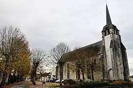 Church of Saint-Euverte | |
Location of Villeherviers | |
 Villeherviers  Villeherviers | |
| Coordinates: 47°22′01″N 1°47′56″E | |
| Country | France |
| Region | Centre-Val de Loire |
| Department | Loir-et-Cher |
| Arrondissement | Romorantin-Lanthenay |
| Canton | Romorantin-Lanthenay |
| Intercommunality | Romorantinais et Monestois |
| Government | |
| • Mayor (2020–2026) | Hubert Bessonnier[1] |
| Area 1 | 38.9 km2 (15.0 sq mi) |
| Population | 428 |
| • Density | 11/km2 (28/sq mi) |
| Time zone | UTC+01:00 (CET) |
| • Summer (DST) | UTC+02:00 (CEST) |
| INSEE/Postal code | 41282 /41200 |
| Elevation | 85–112 m (279–367 ft) |
| 1 French Land Register data, which excludes lakes, ponds, glaciers > 1 km2 (0.386 sq mi or 247 acres) and river estuaries. | |
Geography
The Rère flows northwest through the eastern part of the commune, then flows into the Sauldre, which flows southwest through the middle of the commune.
Population
|
|
References
- "Répertoire national des élus: les maires" (in French). data.gouv.fr, Plateforme ouverte des données publiques françaises. 13 September 2022.
- "Populations légales 2020". The National Institute of Statistics and Economic Studies. 29 December 2022.
Wikimedia Commons has media related to Villeherviers.
This article is issued from Wikipedia. The text is licensed under Creative Commons - Attribution - Sharealike. Additional terms may apply for the media files.