La Ferté-Imbault
La Ferté-Imbault (French pronunciation: [la fɛʁte ɛ̃bo]) is a commune in the Loir-et-Cher department of central France.[3]
La Ferté-Imbault | |
|---|---|
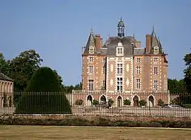 Chateau | |
.svg.png.webp) Coat of arms | |
Location of La Ferté-Imbault | |
 La Ferté-Imbault  La Ferté-Imbault | |
| Coordinates: 47°23′12″N 1°57′23″E | |
| Country | France |
| Region | Centre-Val de Loire |
| Department | Loir-et-Cher |
| Arrondissement | Romorantin-Lanthenay |
| Canton | La Sologne |
| Intercommunality | Sologne des rivières |
| Government | |
| • Mayor (2020–2026) | Isabelle Gasselin[1] |
| Area 1 | 50.02 km2 (19.31 sq mi) |
| Population | 962 |
| • Density | 19/km2 (50/sq mi) |
| Time zone | UTC+01:00 (CET) |
| • Summer (DST) | UTC+02:00 (CEST) |
| INSEE/Postal code | 41084 /41300 |
| Elevation | 94–126 m (308–413 ft) |
| 1 French Land Register data, which excludes lakes, ponds, glaciers > 1 km2 (0.386 sq mi or 247 acres) and river estuaries. | |
La Ferté-Imbault is home to Château de La Ferté-Imbault.
Geography
The Rère forms part of the commune's southern border.
Population
|
|
Veteran cycles rally
The annual rally of the International Veteran Cycle Association was held in La Ferté-Imbault from 1 to 5 June 2011.
References
- "Répertoire national des élus: les maires". data.gouv.fr, Plateforme ouverte des données publiques françaises (in French). 2 December 2020.
- "Populations légales 2020". The National Institute of Statistics and Economic Studies. 29 December 2022.
- INSEE commune file
Wikimedia Commons has media related to La Ferté-Imbault.
This article is issued from Wikipedia. The text is licensed under Creative Commons - Attribution - Sharealike. Additional terms may apply for the media files.