Étaing
Étaing (French pronunciation: [etɛ̃]) is a commune in the Pas-de-Calais department in the Hauts-de-France region of France.[3]
Étaing | |
|---|---|
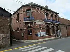 The town hall of Étaing | |
 Coat of arms | |
Location of Étaing | |
 Étaing  Étaing | |
| Coordinates: 50°16′28″N 3°00′02″E | |
| Country | France |
| Region | Hauts-de-France |
| Department | Pas-de-Calais |
| Arrondissement | Arras |
| Canton | Brebières |
| Intercommunality | CC Osartis Marquion |
| Government | |
| • Mayor (2020–2026) | Jean-Louis Capiez[1] |
| Area 1 | 5.1 km2 (2.0 sq mi) |
| Population | 455 |
| • Density | 89/km2 (230/sq mi) |
| Time zone | UTC+01:00 (CET) |
| • Summer (DST) | UTC+02:00 (CEST) |
| INSEE/Postal code | 62317 /62156 |
| Elevation | 37–74 m (121–243 ft) (avg. 43 m or 141 ft) |
| 1 French Land Register data, which excludes lakes, ponds, glaciers > 1 km2 (0.386 sq mi or 247 acres) and river estuaries. | |
Geography
A farming village situated 11 miles (18 km) east of Arras, in the valley of the river Sensée, at the junction of the D39 and D9 roads. The A26 autoroute passes by about half a mile from the village.
Population
| Year | Pop. | ±% p.a. |
|---|---|---|
| 1968 | 353 | — |
| 1975 | 383 | +1.17% |
| 1982 | 366 | −0.65% |
| 1990 | 356 | −0.35% |
| 1999 | 367 | +0.34% |
| 2007 | 423 | +1.79% |
| 2012 | 442 | +0.88% |
| 2017 | 450 | +0.36% |
| Source: INSEE[4] | ||
Places of interest
- The church of Notre-Dame, rebuilt, as was the rest of the village, after World War I.
References
- "Répertoire national des élus: les maires" (in French). data.gouv.fr, Plateforme ouverte des données publiques françaises. 13 September 2022.
- "Populations légales 2020". The National Institute of Statistics and Economic Studies. 29 December 2022.
- INSEE commune file
- Population en historique depuis 1968, INSEE
Wikimedia Commons has media related to Étaing.
This article is issued from Wikipedia. The text is licensed under Creative Commons - Attribution - Sharealike. Additional terms may apply for the media files.