Gennes-Ivergny
Gennes-Ivergny is a commune in the Pas-de-Calais department in the Hauts-de-France region of France.[3]
Gennes-Ivergny | |
|---|---|
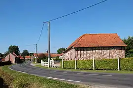 A view within Gennes-Ivergny | |
 Coat of arms | |
Location of Gennes-Ivergny | |
 Gennes-Ivergny  Gennes-Ivergny | |
| Coordinates: 50°15′50″N 2°02′52″E | |
| Country | France |
| Region | Hauts-de-France |
| Department | Pas-de-Calais |
| Arrondissement | Arras |
| Canton | Auxi-le-Château |
| Intercommunality | CC Ternois |
| Government | |
| • Mayor (2020–2026) | Bernard Henno[1] |
| Area 1 | 10.98 km2 (4.24 sq mi) |
| Population | 124 |
| • Density | 11/km2 (29/sq mi) |
| Time zone | UTC+01:00 (CET) |
| • Summer (DST) | UTC+02:00 (CEST) |
| INSEE/Postal code | 62370 /62390 |
| Elevation | 22–132 m (72–433 ft) (avg. 91 m or 299 ft) |
| 1 French Land Register data, which excludes lakes, ponds, glaciers > 1 km2 (0.386 sq mi or 247 acres) and river estuaries. | |
Geography
A small farming village situated on the north bank of the river Authie, the border with the Somme department, 32 miles (51 km) west of Arras, at the junction of the D115 and the D124 roads.
Population
| Year | Pop. | ±% p.a. |
|---|---|---|
| 1968 | 179 | — |
| 1975 | 177 | −0.16% |
| 1982 | 162 | −1.26% |
| 1990 | 161 | −0.08% |
| 1999 | 141 | −1.46% |
| 2007 | 125 | −1.49% |
| 2012 | 127 | +0.32% |
| 2017 | 128 | +0.16% |
| Source: INSEE[4] | ||
Places of interest
- The church of St.Louis, dating from the seventeenth century.
- The Commonwealth War Graves Commission cemetery.
- A sixteenth century manor house with a 5-sided tower.
References
- "Répertoire national des élus: les maires". data.gouv.fr, Plateforme ouverte des données publiques françaises (in French). 9 August 2021.
- "Populations légales 2020". The National Institute of Statistics and Economic Studies. 29 December 2022.
- INSEE commune file
- Population en historique depuis 1968, INSEE
This article is issued from Wikipedia. The text is licensed under Creative Commons - Attribution - Sharealike. Additional terms may apply for the media files.