Achiet-le-Petit
Achiet-le-Petit (French pronunciation: [aʃjɛ lə pəti]) is a commune in the Pas-de-Calais department in northern France.[3]
Achiet-le-Petit | |
|---|---|
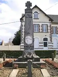
 The monument to the dead, in front of the town hall | |
 Coat of arms | |
Location of Achiet-le-Petit | |
 Achiet-le-Petit  Achiet-le-Petit | |
| Coordinates: 50°07′28″N 2°45′07″E | |
| Country | France |
| Region | Hauts-de-France |
| Department | Pas-de-Calais |
| Arrondissement | Arras |
| Canton | Bapaume |
| Intercommunality | Sud-Artois |
| Government | |
| • Mayor (2020–2026) | Philippe Lesage[1] |
| Area 1 | 7.25 km2 (2.80 sq mi) |
| Population | 312 |
| • Density | 43/km2 (110/sq mi) |
| Time zone | UTC+01:00 (CET) |
| • Summer (DST) | UTC+02:00 (CEST) |
| INSEE/Postal code | 62006 /62121 |
| Elevation | 97–139 m (318–456 ft) (avg. 123 m or 404 ft) |
| 1 French Land Register data, which excludes lakes, ponds, glaciers > 1 km2 (0.386 sq mi or 247 acres) and river estuaries. | |
Geography
A farming village located 13 miles (21 km) south of Arras, at the D27 and D9 road junction.
History
- In 1700, Charles Jacques Adrien de Mullet, seigneur of Wancquetin demolished the remains of the small castle, knocking down the motte and filling in most of the moat. He then built a chateau, using white bricks and stones, enclosed by large garden walls.
- In 1749 the castle was completed by the laying out of a wide terrace (500' long by 40' wide) on which there were two guns donated by Louis XV. During the French Revolution, the cannons were melted down and thrown down a well. In the 19th century, they were found and returned to the Diesbach family.
- In 1789, the castle was looted and destroyed during the Revolution, leaving no trace of the edifice. The stones and bricks of the castle were used by the locals to construct homes which were in turn destroyed during World War I.
- In the 19th century, the land stolen and sold during the French Revolution was restored to the Diesbach family.
- The commune was involved in the theatre of operations of the Battle of Bapaume (1871), during the Franco-Prussian War.
- After World War I, the town was awarded the Croix de Guerre.
Population
| Year | Pop. | ±% p.a. |
|---|---|---|
| 1968 | 358 | — |
| 1975 | 358 | +0.00% |
| 1982 | 355 | −0.12% |
| 1990 | 348 | −0.25% |
| 1999 | 328 | −0.66% |
| 2007 | 326 | −0.08% |
| 2012 | 330 | +0.24% |
| 2017 | 303 | −1.69% |
| Source: INSEE[4] | ||
Sights
- The church of St.Martin, dating from the twentieth century.
References
- "Répertoire national des élus: les maires" (in French). data.gouv.fr, Plateforme ouverte des données publiques françaises. 13 September 2022.
- "Populations légales 2020". The National Institute of Statistics and Economic Studies. 29 December 2022.
- INSEE commune file
- Population en historique depuis 1968, INSEE
This article is issued from Wikipedia. The text is licensed under Creative Commons - Attribution - Sharealike. Additional terms may apply for the media files.