General Nakar
General Nakar, officially the Municipality of General Nakar (Tagalog: Bayan ng Heneral Nakar, Ilocano: Ili ti Heneral Nakar), is a 1st class municipality in the province of Quezon, Philippines. According to the 2020 census, it has a population of 34,225 people.[3] It is the largest municipality in the province of Quezon in terms of land area, occupying 1,343.75 kilometers (834.97 mi). It is accessible by land from Metro Manila, passing through Marcos Highway (Marikina-Infanta Highway).
General Nakar | |
|---|---|
| Municipality of General Nakar | |
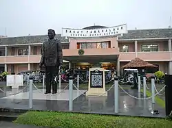
 Municipal Hall | |
 Flag  Seal | |
| Nickname: Largest municipality of Luzon Island | |
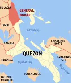
 Map of Quezon with General Nakar highlighted | |
OpenStreetMap | |
.svg.png.webp) General Nakar Location within the Philippines | |
| Coordinates: 14°45′47″N 121°38′06″E | |
| Country | Philippines |
| Region | Calabarzon |
| Province | Quezon |
| District | 1st district |
| Founded | July 21, 1949 |
| Named for | Guillermo Peñamante Nakar |
| Barangays | 19 (see Barangays) |
| Government | |
| • Type | Sangguniang Bayan |
| • Mayor | Eliseo R. Ruzol |
| • Vice Mayor | Rodel A. Avellaneda |
| • Representative | Wilfrido Mark M. Enverga |
| • Municipal Council | Members |
| • Electorate | 24,645 voters (2022) |
| Area | |
| • Total | 1,343.75 km2 (518.82 sq mi) |
| Elevation | 234 m (768 ft) |
| Highest elevation | 1,528 m (5,013 ft) |
| Lowest elevation | 0 m (0 ft) |
| Population (2020 census)[3] | |
| • Total | 34,225 |
| • Density | 25/km2 (66/sq mi) |
| • Households | 8,297 |
| Demonym | Nakarin |
| Economy | |
| • Income class | 1st municipal income class |
| • Poverty incidence | 18.59 |
| • Revenue | ₱ 342.5 million (2020) |
| • Assets | ₱ 807.8 million (2020) |
| • Expenditure | ₱ 274.2 million (2020) |
| • Liabilities | ₱ 106.7 million (2020) |
| Service provider | |
| • Electricity | Quezon 2 Electric Cooperative (QUEZELCO 2) |
| Time zone | UTC+8 (PST) |
| ZIP code | 4338 |
| PSGC | |
| IDD : area code | +63 (0)42 |
| Native languages | Umiray Dumaget Sinauna Tagalog |
| Website | www |
It was named after Major General Guillermo Peñamante Nakar (1905–1942), the martyred leader of the 1st Battalion of the 71st Infantry Division of the USAFFE against the attacking Japanese Forces and a native of barangay Anoling.[5]
History
In the late 1940s, the locals, headed by forester Julian Avellano Sr., initiated a petition to create the municipality. It came into fruition with the help of Tayabas's 1st district Representative Fortunato Suarez and Quezon Governor Gregorio Santayana.[5]
On July 21, 1949, the barrios of Anoling, Banglos, Batangan, Magsikap, Maligaya, Minahan, Katablingan and Pamplona, then part of the municipality of Infanta, were separated and constituted into a new and separate municipality known as General Nakar, by virtue of Executive Order No. 246 signed by President Elpidio Quirino.[6]
Geography
General Nakar is bounded on the north by Dingalan, Aurora, west by Doña Remedios Trinidad and Norzagaray (Bulacan) and Rizal province, south by Infanta, and east by the Benham Rise or Plateau and Philippine Sea.
Barangays

General Nakar is composed of 19 barangays. Each barangay consists of puroks and some have sitios.
- Anoling
- Banglos
- Batangan
- Catablingan
- Canaway
- Lumutan
- Mahabang Lalim
- Maigang
- Maligaya
- Magsikap
- Minahan Norte
- Minahan Sur
- Pagsangahan
- Pamplona
- Pisa
- Poblacion
- Sablang
- San Marcelino
- Umiray
Climate
| Climate data for General Nakar, Quezon | |||||||||||||
|---|---|---|---|---|---|---|---|---|---|---|---|---|---|
| Month | Jan | Feb | Mar | Apr | May | Jun | Jul | Aug | Sep | Oct | Nov | Dec | Year |
| Average high °C (°F) | 26 (79) |
27 (81) |
28 (82) |
31 (88) |
31 (88) |
30 (86) |
29 (84) |
29 (84) |
29 (84) |
29 (84) |
28 (82) |
27 (81) |
29 (84) |
| Average low °C (°F) | 22 (72) |
22 (72) |
22 (72) |
23 (73) |
25 (77) |
25 (77) |
25 (77) |
25 (77) |
24 (75) |
24 (75) |
23 (73) |
22 (72) |
24 (74) |
| Average precipitation mm (inches) | 40 (1.6) |
33 (1.3) |
35 (1.4) |
38 (1.5) |
138 (5.4) |
190 (7.5) |
242 (9.5) |
216 (8.5) |
224 (8.8) |
200 (7.9) |
114 (4.5) |
94 (3.7) |
1,564 (61.6) |
| Average rainy days | 12.2 | 9.0 | 11.0 | 11.7 | 21.5 | 24.0 | 27.2 | 26.1 | 26.8 | 22.3 | 16.3 | 15.1 | 223.2 |
| Source: Meteoblue[7] | |||||||||||||
Demographics
| Year | Pop. | ±% p.a. |
|---|---|---|
| 1960 | 5,494 | — |
| 1970 | 8,569 | +4.54% |
| 1975 | 11,751 | +6.54% |
| 1980 | 12,127 | +0.63% |
| 1990 | 18,323 | +4.21% |
| 1995 | 21,121 | +2.70% |
| 2000 | 23,678 | +2.48% |
| 2007 | 24,895 | +0.69% |
| 2010 | 25,973 | +1.55% |
| 2015 | 29,705 | +2.59% |
| 2020 | 34,225 | +2.82% |
| Source: Philippine Statistics Authority[8][9][10][11] | ||
Economy
References
- Municipality of General Nakar | (DILG)
- "2015 Census of Population, Report No. 3 – Population, Land Area, and Population Density" (PDF). Philippine Statistics Authority. Quezon City, Philippines. August 2016. ISSN 0117-1453. Archived (PDF) from the original on May 25, 2021. Retrieved July 16, 2021.
- Census of Population (2020). "Region IV-A (Calabarzon)". Total Population by Province, City, Municipality and Barangay. Philippine Statistics Authority. Retrieved 8 July 2021.
- "PSA Releases the 2018 Municipal and City Level Poverty Estimates". Philippine Statistics Authority. 15 December 2021. Retrieved 22 January 2022.
- "About Us". General Nakar. Retrieved August 12, 2022.
- Executive Order No. 246, s. 1949 (21 July 1949). Organizing certain portions of the municipalities of Baler and Infanta, Quezon Province, into independent municipalities, under the names of Maria Aurora and General Nakar, respectively. Official Gazette of the Republic of the Philippines. Retrieved August 12, 2022.
- "General Nakar: Average Temperatures and Rainfall". Meteoblue. Retrieved 27 January 2020.
- Census of Population (2015). "Region IV-A (Calabarzon)". Total Population by Province, City, Municipality and Barangay. Philippine Statistics Authority. Retrieved 20 June 2016.
- Census of Population and Housing (2010). "Region IV-A (Calabarzon)". Total Population by Province, City, Municipality and Barangay. National Statistics Office. Retrieved 29 June 2016.
- Censuses of Population (1903–2007). "Region IV-A (Calabarzon)". Table 1. Population Enumerated in Various Censuses by Province/Highly Urbanized City: 1903 to 2007. National Statistics Office.
- "Province of Quezon". Municipality Population Data. Local Water Utilities Administration Research Division. Retrieved 17 December 2016.
- "Poverty incidence (PI):". Philippine Statistics Authority. Retrieved December 28, 2020.
- "Estimation of Local Poverty in the Philippines" (PDF). Philippine Statistics Authority. 29 November 2005.
- "2003 City and Municipal Level Poverty Estimates" (PDF). Philippine Statistics Authority. 23 March 2009.
- "City and Municipal Level Poverty Estimates; 2006 and 2009" (PDF). Philippine Statistics Authority. 3 August 2012.
- "2012 Municipal and City Level Poverty Estimates" (PDF). Philippine Statistics Authority. 31 May 2016.
- "Municipal and City Level Small Area Poverty Estimates; 2009, 2012 and 2015". Philippine Statistics Authority. 10 July 2019.
- "PSA Releases the 2018 Municipal and City Level Poverty Estimates". Philippine Statistics Authority. 15 December 2021. Retrieved 22 January 2022.
External links
- General Nakar Profile at PhilAtlas.com
- Philippine Standard Geographic Code
- Philippine Census Information
- Local Governance Performance Management System Archived 2016-03-04 at the Wayback Machine
- Keith Anthony S. Fabro (15 May 2023). "Organic farming, and community spirit, buoy a typhoon-battered Philippine town". Mongabay. Retrieved 19 May 2023.