Graincourt-lès-Havrincourt
Graincourt-lès-Havrincourt is a commune in the Pas-de-Calais department in the Hauts-de-France region of France.[3]
Graincourt-lès-Havrincourt | |
|---|---|
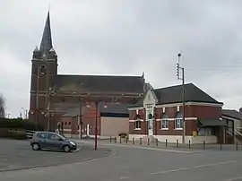 The center of the commune | |
 Coat of arms | |
Location of Graincourt-lès-Havrincourt | |
 Graincourt-lès-Havrincourt  Graincourt-lès-Havrincourt | |
| Coordinates: 50°08′43″N 3°06′37″E | |
| Country | France |
| Region | Hauts-de-France |
| Department | Pas-de-Calais |
| Arrondissement | Arras |
| Canton | Bapaume |
| Intercommunality | CC Osartis Marquion |
| Government | |
| • Mayor (2020–2026) | Jean-Marcel Dumont[1] |
| Area 1 | 11.57 km2 (4.47 sq mi) |
| Population | 649 |
| • Density | 56/km2 (150/sq mi) |
| Time zone | UTC+01:00 (CET) |
| • Summer (DST) | UTC+02:00 (CEST) |
| INSEE/Postal code | 62384 /62147 |
| Elevation | 61–101 m (200–331 ft) (avg. 79 m or 259 ft) |
| 1 French Land Register data, which excludes lakes, ponds, glaciers > 1 km2 (0.386 sq mi or 247 acres) and river estuaries. | |
Geography
A farming village situated 22 miles (35 km) southeast of Arras, at the junction of the D15 and C5 roads. The A26 autoroute junction with the A2 autoroute is only half a mile from the commune.
Population
| Year | Pop. | ±% p.a. |
|---|---|---|
| 1968 | 633 | — |
| 1975 | 605 | −0.64% |
| 1982 | 610 | +0.12% |
| 1990 | 611 | +0.02% |
| 1999 | 617 | +0.11% |
| 2007 | 615 | −0.04% |
| 2012 | 635 | +0.64% |
| 2017 | 638 | +0.09% |
| Source: INSEE[4] | ||
Places of interest
- The church of St.Martin, rebuilt along with the rest of the village after World War I.
- The Commonwealth War Graves Commission cemetery.
References
- "Répertoire national des élus: les maires". data.gouv.fr, Plateforme ouverte des données publiques françaises (in French). 2 December 2020.
- "Populations légales 2020". The National Institute of Statistics and Economic Studies. 29 December 2022.
- INSEE commune file
- Population en historique depuis 1968, INSEE
This article is issued from Wikipedia. The text is licensed under Creative Commons - Attribution - Sharealike. Additional terms may apply for the media files.