Gurdaspur district
Gurdaspur district is a district in the Majha region of the state of Punjab, India. Gurdaspur is the district headquarters. It internationally borders Narowal District of Pakistani Punjab, and the districts of Amritsar, Pathankot, Kapurthala and Hoshiarpur. Two main rivers Beas and Ravi passes through the district. The Mughal emperor Akbar is said to have been enthroned in a garden near Kalanaur, a historically important town in the district.[1] The district is at the foothills of the Himalayas.
Gurdaspur district | |
|---|---|
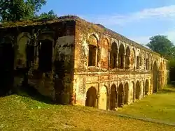 Sujanpur Fort | |
.svg.png.webp) Location in Punjab | |
| Coordinates: 31°55′N 75°15′E | |
| Country | |
| State | Punjab |
| Headquarters | Gurdaspur |
| Area | |
| • Total | 2,610 km2 (1,010 sq mi) |
| Population (2011)[‡] | |
| • Total | 2,298,323 |
| • Density | 880/km2 (2,300/sq mi) |
| Languages | |
| • Official | Punjabi |
| Time zone | UTC+5:30 (IST) |
| Vehicle Code | PB 06,PB 18,PB 58,PB 85, PB 99 |
| Literacy | 79.95% |
| Website | gurdaspur |
As of 2011 it is the third most populous district of Punjab (out of 22), after Ludhiana and Amritsar.[2] Batala, with 31% of the district's population, is its largest city.
History

Obv: Standing figure, probably of Vishvamitra, Kharoshthi legend, around: Mahadevasa Dharaghoshasa/Odumbarisa "Great Lord King Dharaghosha/Prince of Audumabara", across: Viçvamitra "Vishvamitra".
Rev: Trident battle-axe, tree with railing, Brahmi legend identical in content to the obverse.[3]
1700s
This area was used as a base by Banda Singh Bahadur to raid the area upto Lahore. The Mughal emperor Bahadur Shah conducted an expedition against him in 1711, but with only temporary effect. Banda Singh Bahadur fought his last battle against Mughals at Gurdas Nangal and was captured.[4][5]
On 17 May 1746, the Chhota Ghallughara (smaller Sikh genocide) took place. Approximately 10,000 to 15,000 Sikhs were killed in battle on a single day in Kahnuwan, near Gurdaspur. Under the Lahore governorship of Yahiya Khan, Lakhpat Rai (revenue minister) and Shah Navaz Khan were directed to avenge the killing of Lakhpat Rai's brother, Jaspat Rai. An official decree to exterminate Sikhs was issued.
British Raj

During British Rule the district of Gurdaspur was a subdivision of Lahore Division, the district itself was administratively subdivided into four tehsils: Gurdaspur, Batala, Shakargarh and Pathankot. According to the 1881 census the population of the district was 823,695 this had risen by over 100,000 to 943,922 in the 1891 census. However the 1901 census recorded a fall in population – 940,334, this was largely due to emigration – some 44,000 settlers settling in Chenab colony. According to the 1901 census there were 463,371 Muslims (49%), 380,636 Hindus (over 40%) and 91,756 (10%) Sikhs. Mirza Ghulam Ahmad who founded the Ahmadiyya movement had followers here.[6]
During the partition of India in 1947 the future of Gurdaspur was highly contested. According to the 1941 census, the population of this district had a narrow 51.14% Muslim majority. Radcliffe Award of the boundary gave only the Shakargarh tehsil of the district to Pakistan, and the rest to India. The Muslim population of the eastern tehsils migrated to Pakistan as refugees, and the Hindus and Sikhs of Shakargarh migrated to Gurdaspur after crossing the Ravi Bridge. They settled and spread in the Gurdaspur district.
Modern India
On 27 July 2011 a part of district is carved out to form a new Pathankot district, which was earlier part of Gurdaspur. The Pathankot district comprises two sub-divisions of Pathankot and Dharkalan along with two sub-tehsils namely Narot Jaimal Singh and Bamial.
Geography
Location
The Gurdaspur district is in the north of Punjab state. It falls in the Jalandhar division and is sandwiched between rivers Ravi and Beas. The district lies between north-latitude 31°36' and 32°34' and east longitude 74°56' and 75°24' and shares common boundaries with Pathankot district in the north, Beas River in the north-east, Hoshiarpur district in the south-east, Kapurthala district in the south, Amritsar district in the south-west and Pakistan in the north-west.
Government and politics
Politics
| No. | Constituency | Name of MLA | Party | Bench | |
|---|---|---|---|---|---|
| 4 | Gurdaspur | Barindermeet Singh Pahra | Indian National Congress | Opposition | |
| 5 | Dina Nagar (SC) | Aruna Chaudhary | Indian National Congress | Opposition | |
| 6 | Qadian | Partap Singh Bajwa | Indian National Congress | Opposition | |
| 7 | Batala | Amansher Singh (Shery Kalsi) | Aam Aadmi Party | Government | |
| 8 | Sri Hargobindpur (SC) | Amarpal Singh | Aam Aadmi Party | Government | |
| 9 | Fatehgarh Churian | Tripat Rajinder Singh Bajwa | Indian National Congress | Opposition | |
| 10 | Dera Baba Nanak | Sukhjinder Singh Randhawa | Indian National Congress | Opposition | |
Tehsil
|
Sub Tehsils (Total : 7)
| Sr. No. | Sub Tehsil Name |
|---|---|
| 1. | Kahnuwan |
| 2. | Sri Hargobindpur |
| 3. | Qadian |
| 4. | Fatehgarh Churian |
| 5. | Dhariwal |
| 6. | Naushera Majha Singh |
| 7. | Dorangla |
C.D. Blocks (Total : 11)
| Sr. No. | Block Name |
|---|---|
| 1. | Gurdaspur |
| 2. | Kalanaur |
| 3. | Dhariwal |
| 4. | Kahnuwan |
| 5. | Dinanagar |
| 6. | Batala |
| 7. | Fatehgarh Churian |
| 8. | Dera Baba Nanak |
| 9. | Sri Hargobindpur |
| 10. | Qadian |
| 11. | Dorangla |
Municipal Corporation (Nagar Nigam)
| Sr. No. | Corporation Name |
|---|---|
| 1. | Batala |
Municipal Councils
| Sr. No. | Municipal Name |
|---|---|
| 1. | Gurdaspur |
| 2. | Dhariwal |
| 3. | Dinanagar |
| 4. | Sri Hargobindpur |
| 5. | Dera Baba Nanak |
| 6. | Fatehgarh Churian |
| 7. | Qadian |
Demographics
Population
| Year | Pop. | ±% p.a. |
|---|---|---|
| 1901 | 702,372 | — |
| 1911 | 622,008 | −1.21% |
| 1921 | 634,394 | +0.20% |
| 1931 | 718,523 | +1.25% |
| 1941 | 854,968 | +1.75% |
| 1951 | 851,140 | −0.04% |
| 1961 | 980,868 | +1.43% |
| 1971 | 1,229,464 | +2.28% |
| 1981 | 1,513,435 | +2.10% |
| 1991 | 1,756,732 | +1.50% |
| 2001 | 2,103,455 | +1.82% |
| 2011 | 2,298,323 | +0.89% |
| source:[7] | ||
According to the 2011 census Gurdaspur district has a population of 2,298,323,[2] roughly equal to the nation of Latvia[8] or the US state of New Mexico.[9] This gives it a ranking of 196th in India (out of a total of 640).[2] The district has a population density of 649 inhabitants per square kilometre (1,680/sq mi).[2] Its population growth rate over the decade 2001–2011 was 9.3%.[2] Gurdaspur has a sex ratio of 895 females for every 1000 males,[2] and a literacy rate of 79.95%.[2]
After the separation of the Pathankot tehsil into a separate district in 2011, the residual district has a population of 1,621,725 of which 1,260,572 were rural and 361,153 were urban. Scheduled Castes have a population of 373,544 (23.03%) of the population. Punjabi is the predominant language, spoken by 98.27% of the population.[10]
Gender
The table below shows the sex ratio of Gurdaspur through the years, according to various census years.[11] Note:- The figure for 2011 does not include the data of the areas that currently form Pathankot district, which were separated from Gurdaspur on that year, to form a new district.
| Year
(Census) |
Sex Ratio |
|---|---|
| 2011 | 907 |
| 2001 | 890 |
| 1991 | 903 |
| 1981 | 907 |
| 1971 | 890 |
| 1961 | 869 |
| 1951 | 846 |
| 1941 | 843 |
| 1931 | 809 |
| 1921 | 794 |
| 1911 | 774 |
| 1901 | 853 |
Rural and Urban
The table below shows the percentage of rural population through the decades.[13] Note:- The separation of the areas in the current Pathankot district in 2011, may have significantly changed the numbers and figures for that year.
| Year | Percentage |
|---|---|
| 2011 | 77.73% |
| 2001 | 74.56% |
| 1991 | 78.02% |
| 1981 | 78.31% |
| 1971 | 79.7% |
The table below gives the absolute number of rural and urban population through the years.[15][16] Note:- The separation of the areas in the current Pathankot district in 2011, may have significantly changed the numbers and figures for that year.
| Year | Urban | Rural |
|---|---|---|
| 2011 | 3,61,153 | 12,60,572 |
| 2001 | 5,35,223 | 15,68,788 |
| 1991 | 3,86,412 | 13,71,796 |
| 1981 | 3,28,268 | 11,85,167 |
| 1971 | 2,49,084 | 9,80,165 |
Religion
Religion in Gurdaspur District, 2011
Sikhism is the largest religion in the residual district with 950,016 (58.58%), while Hinduism is the second-largest with 476,095 (29.36%). Christians are the third-largest community with 169,295 (10.44%), the highest share of Christians in the state, and Muslims 13,350 (0.82%).[19] Before Partition, undivided Gurdaspur district had a slight Muslim majority with a large Hindu minority and smaller Sikh and Christian populations. The area which now forms the current district had a Muslim majority and a large Sikh minority, with smaller Hindu and Christian populations.
| Religion | Population (1941)[20]: 61–62 | Percentage (1941) | Population (2011)[21] | Percentage (2011) |
|---|---|---|---|---|
| Islam |
380,775 | 53.72% | 13,350 | 0.82% |
| Sikhism |
193,108 | 27.24% | 950,016 | 58.58% |
| Hinduism |
90,412 | 12.75% | 476,095 | 29.36% |
| Christianity |
43,176 | 6.09% | 169,295 | 10.44% |
| Others [lower-alpha 2] | 1,401 | 0.20% | 12,969 | 0.80% |
| Total Population | 708,872 | 100% | 1,621,725 | 100% |
The table below shows the numbers of different religious groups in the urban areas of Gurdaspur district, through the years.[22][23][24][25][26][27] Note:- The separation of the areas in the current Pathankot district in 2011, may have significantly changed the numbers and figures for that year.
| Year | Hindu | Sikh | Christian | Muslim | Other Religions |
|---|---|---|---|---|---|
| 2011 | 4,78,989 | 1,40,536 | 26,151 | 8,292 | 5,351 |
| 2001 | 3,79,724 | 1,28,697 | 21,668 | 4,329 | 807 |
| 1991 | 2,51,831 | 66,020 | 8,713 | 1,540 | 164 |
The table below shows the absolute numbers of different religious groups in the rural areas of Gurdaspur district, through the years.[29][30][31][32][33][34] Note:- The separation of the areas in the current Pathankot district in 2011, may have significantly changed the numbers and figures for that year.
| Year | Hindu | Sikh | Christian | Muslim | Other Religions |
|---|---|---|---|---|---|
| 2011 | 5,95,343 | 8,62,338 | 1,50,436 | 5,351 | 11,512 |
| 2001 | 6,16,522 | 8,06,266 | 1,27,315 | 807 | 2,246 |
| 1991 | 4,76,531 | 6,09,380 | 90,924 | 164 | 510 |
Historical

| Religion | Population | Percentage |
|---|---|---|
| Islam |
589,923 | 51.14% |
| Hinduism |
290,774 | 25.21% |
| Sikhism |
221,261 | 19.18% |
| Christianity |
51,522 | 4.47% |
| Others [lower-alpha 2] | 31 | 0% |
| Total Population | 1,153,511 | 100% |
Health
The number of registerd doctors in the Gurdaspur district were 1,642 and 6,118 registered nurses, as of year 2018.[37][38]
The table given below shows the population served per doctor in Gurdaspur district, by years.[39]
| Year | Population | Year | Population |
|---|---|---|---|
| 2018 | 1,058 | 2000 | 2,490 |
| 2012 | 1,671 | 1999 | 2,382 |
| 2010 | 1,845 | 1998 | 2,377 |
| 2008 | 2,091 | 1997 | 2,441 |
| 2007 | 2,108 | 1996 | 2,536 |
| 2006 | 1,973 | 1995 | 2,558 |
| 2005 | 2,228 | 1994 | 2,598 |
| 2004 | 2,408 | 1993 | 3,019 |
| 2003 | 2,478 | 1992 | 2,043 |
| 2002 | 2,452 | 1991 | 2,806 |
| 2001 | 2,547 | 1990 | 2,986 |
Notable people
Science and Academia
- Naresh Trehan, a cardiovascular and cardiothoracic surgeon
- Ishfaq Ahmad - Pakistani nuclear physicist
- Bhai Ram Singh - An influential architect
- Sucha Singh Gill, an economist with areas of expertise in development economics, international economics and economy of Punjab
- Sardul Singh Guraya, a biologist, known for his contributions in the fields of reproductive physiology and developmental biology
Sports
- Dinesh Khanna - Badminton player
- Surjit Singh Randhawa - hockey player
- Manpreet Gony - cricketer
- Prabhjot Singh (Indian hockey player)
- Shivil Kaushik - cricketer
Military
- Capt. Gurbachan Singh Salaria - Param Vir Chakra awardee, posthumous
- Lt. Navdeep Singh - Ashoka Chakra awardee, posthumous
- Dilbagh Singh - Air Chief Marshal
- Admiral Sureesh Mehta, served as 19th Chief of the Indian Navy from 31 October 2006 until 31 August 2009 and was the first service chief from India's armed forces to be born after Indian Independence
Art and culture
- Dev Anand - Indian actor
- Premchand Dogra - Bodybuilder, Mr. Universe, Mr. India
- Chetan Anand - director
- Vijay Anand - director
- Vinod Khanna - Indian actor
- Shiv Kumar Batalvi - Punjabi writer
- Romesh Sharma - Indian Actor and producer
- Jasbir Jassi - Bhangra singer
- Guru Randhawa - Punjabi singer
- Preet Harpal - Punjabi singer and actor
- Iqbal Bahu - Pakistani Sufi singer
- Alla Rakha - Tabla player
- Nek Chand Saini - Indian artist and creator of the Rock Garden of Chandigarh
- Gurpreet Ghuggi - actor and comedian-turned-politician
- Ranjit Bawa - Punjabi singer and actor
- Nimrat Khaira - Punjabi singer and actress
- Satinder Satti - anchor-singer
- Varinder Singh Ghuman - bodybuilder
- Principal Sujan Singh - Punjabi writer
- Sobha Singh - painter
- Baba Jaimal Singh - Punjabi spiritual leader
- Mirza Nasir Ahmad (Khalifatul Massih III)
- Mirza Tahir Ahmad (Khalifatul Massih IV)
- Mirza Ghulam Ahmad - Founder of the Ahmaddiya movement
- Mirza Basheer-ud-Din Mahmood Ahmad (Khalifatul Massih II)
- Ghulam Ahmed Pervez - Islamic scholar
- Mumtaz Mufti - Urdu writer
- Sunanda Sharma - Punjabi singer and actress
- Harnaaz Sandhu - Miss Universe 2021
- AP Dhillon - Singer/songwriter, music producer
Politics
- Ashwani Kumar - Former Union Minister
- Robert Masih Nahar - Spanish senator
- Teja Singh (singh sabha movement)
- Pratap Singh Bajwa - Rajya Sabha MP from Punjab
- Teja Singh Akarpuri - Jathedar of Akal Takht
References
- "About District". gurdaspur.nic.in. Archived from the original on 2 August 2005. Retrieved 29 March 2018.
- "District Census 2011". Census2011.co.in. 2011. Retrieved 30 September 2011.
- Ancient India, from the earliest times to the first century, A.D by Rapson, E. J. p.154
- "History | District Gurdaspur,Government of Punjab | India".
- "District Heritage Society Gurdaspur" (PDF).
- "Imperial Gazetteer2 of India, Volume 12, page 395 -- Imperial Gazetteer of India -- Digital South Asia Library". dsal.uchicago.edu. Retrieved 29 March 2018.
- "Decadal Variation In Population Since 1901".
- US Directorate of Intelligence. "Country Comparison:Population". Archived from the original on 27 September 2011. Retrieved 1 October 2011.
Latvia 2,204,708 July 2011 est.
- "2010 Resident Population Data". U. S. Census Bureau. Archived from the original on 23 August 2011. Retrieved 30 September 2011.
New Mexico – 2,059,179
- "Table C-16 Population by Mother Tongue: Punjab". censusindia.gov.in. Registrar General and Census Commissioner of India.
- https://punjab.data.gov.in/catalog/district-wise-decadal-sex-ratio-punjab
- https://punjab.data.gov.in/catalog/district-wise-decadal-sex-ratio-punjab
- https://punjab.data.gov.in/resource/district-wise-rural-population-percentage-total-population-1971-2011
- https://punjab.data.gov.in/resource/district-wise-rural-population-percentage-total-population-1971-2011
- https://punjab.data.gov.in/resource/district-wise-no-total-rural-population-1971-2011
- https://punjab.data.gov.in/resource/district-wise-no-total-urban-population-1971-2011
- https://punjab.data.gov.in/resource/district-wise-no-total-rural-population-1971-2011
- https://punjab.data.gov.in/resource/district-wise-no-total-urban-population-1971-2011
- "C-1 Population By Religious Community Data - Census 2011 - Punjab". censusindia.gov.in. Office of the Registrar General & Census Commissioner, India.
- "CENSUS OF INDIA, 1941 VOLUME VI PUNJAB PROVINCE". Retrieved 21 July 2022.
- "Table C-01 Population by Religious Community: Punjab". censusindia.gov.in. Registrar General and Census Commissioner of India.
- https://punjab.data.gov.in/catalog/district-wise-population-religion-punjab
- https://punjab.data.gov.in/resource/district-wise-no-hindu-urban-population-1991-2011
- https://punjab.data.gov.in/resource/district-wise-no-sikh-urban-population-1991-2011
- https://punjab.data.gov.in/resource/district-wise-no-muslim-urban-population-1991-2011
- https://punjab.data.gov.in/resource/district-wise-no-christian-urban-population-1991-2011
- https://punjab.data.gov.in/resource/district-wise-no-other-religion-urban-population-1991-2011
- https://punjab.data.gov.in/catalog/district-wise-population-religion-punjab
- https://punjab.data.gov.in/catalog/district-wise-population-religion-punjab
- https://punjab.data.gov.in/resource/district-wise-no-hindu-rural-population-1991-2011
- https://punjab.data.gov.in/resource/district-wise-no-sikh-rural-population-1991-2011
- https://punjab.data.gov.in/resource/district-wise-no-muslim-rural-population-1991-2011
- https://punjab.data.gov.in/resource/district-wise-no-christian-rural-population-1991-2011
- https://punjab.data.gov.in/resource/district-wise-no-other-religion-rural-population-1991-2011
- https://punjab.data.gov.in/catalog/district-wise-population-religion-punjab
- Singh, Kirpal (2005). "Memorandum Submitted to the Punjab Boundary Commission by the Indian National Congress". Select Documents on Partition of Punjab - 1947: India and Pakistan: Punjab, Haryana and Himachal-India and Punjab-Pakistan. Delhi: National Book Shop. p. 212. ISBN 9788171164455. Retrieved 17 March 2022.
- https://data.gov.in/resource/districtwise-registered-number-doctors-punjab-1968-2018-april-march
- https://data.gov.in/resource/district-wise-registered-nurses-punjab-1968-2018-april-march
- https://punjab.data.gov.in/resource/districtwise-population-served-doctor-punjab-1968-2018-april-march
- https://punjab.data.gov.in/resource/districtwise-population-served-doctor-punjab-1968-2018-april-march
- Includes Gurdaspur and Batala tehsils, which are the tehsils which now cover the area of Gurdaspur district
- Including Jainism, Buddhism, Zoroastrianism, Judaism, Ad-Dharmis, or not stated
- 1941 census: Including Ad-Dharmis
External links
Places adjacent to Gurdaspur district | ||||||||||||||||
|---|---|---|---|---|---|---|---|---|---|---|---|---|---|---|---|---|
| ||||||||||||||||
| Topics |  | |
|---|---|---|
| Administration | ||
| Culture |
| |
| Divisions |
| |
| Districts | ||
| Major Cities | ||