Haute Matsiatra
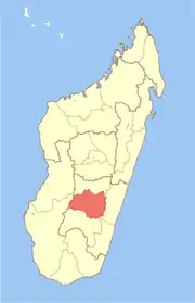
Haute Matsiatra (in Malagasy: Matsiatra Ambony) is a region in Madagascar. It borders Amoron'i Mania region in north, Vatovavy-Fitovinany in east, Ihorombe in south and Atsimo-Andrefana in west. The capital of the region is Fianarantsoa, and the population was 1,447,296 in 2018. The area is 21,080 km2 (8,139 sq mi).[3]
Haute Matsiatra Region
Matsiatra Ambony | |
|---|---|
Region | |
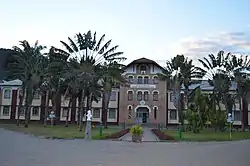
 Collège Saint François Xavier in Fianarantsoa | |
 Coat of arms | |
 Location in Madagascar | |
| Country | |
| Capital | Fianarantsoa |
| Government | |
| • Gouvernor | Lova Narivelo Razafindrafito |
| Area | |
| • Total | 21,080 km2 (8,140 sq mi) |
| Population (2018)[3] | |
| • Total | 1,447,296 |
| • Density | 53.5/km2 (139/sq mi) |
| Time zone | UTC3 (EAT) |
| HDI (2018) | 0.516[4] low · 12th of 22 |

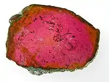
Liddicoatite, a tourmaline from Ambohimahasoa District. Size: 5.8 x 4.7 x 0.4 cm., polished slice.
Economy
Matsiatra Ambony is the top wine producing region of Madagascar, with wineyards in Ambalavao, Famoriana and Isandra (district). In Sahambavy is found the only tea production of the country.
Administrative divisions
Haute Matsiatra Region is divided into seven districts, which are sub-divided into 84 communes.
- Ambalavao District - 17 communes; 215,094 inhabitants
- Ambohimahasoa District - 17 communes; 220,525 inhabitants
- Fianarantsoa District - 1 commune; 195,478 inhabitants
- Ikalamavony District - 8 communes; 91,797 inhabitants
- Isandra District - 13 communes; 132,971 inhabitants
- Lalangina District - 13 communes; 174,165 inhabitants
- Vohibato District - 15 communes; 201,666 inhabitants
Transport
Airports
- Ambalavao Airport
- Fianarantsoa Airport
Railways
The Fianarantsoa-Côte Est railway has its endpoint in Fianarantsoa. It leads to the east coast and Manakara.
Roads
- National road 7 (Antananarivo - Tulear)
- National road 25 (Fianarantsoa - Mananjary)
- National road 42 A short secondary highway from Fianarantsoa to Isorana.
- National road 45 - a shortcut from National road 7 to National road 25.
Rivers
The main river is the Matsiatra.
Protected areas
- Part of Fandriana-Vondrozo Corridor
- Andringitra National Park
- Part of Ranomafana National Park
- Anja Community Reserve
- the cliffs & caves of Isandra
See also
References
- EDBM
- Ralison, Eliane; Goossens, Frans. "Madagascar: Profil des marchés pour les évaluations d'urgence de la sécurité alimentaire" (PDF) (in French). Programme Alimentaire Mondial, Service de l’Evaluation des besoins d’urgence (ODAN). Retrieved 2008-03-01.
- "Troisieme Recensement General de la Population et de L'Habitation (RGPH-3) Resultats Provisoires" (PDF). Institut National de la Statistique Madagascar. Archived from the original (PDF) on November 18, 2020. Retrieved May 23, 2020.
- "Sub-national HDI - Area Database - Global Data Lab". hdi.globaldatalab.org. Retrieved 2018-09-13.
This article is issued from Wikipedia. The text is licensed under Creative Commons - Attribution - Sharealike. Additional terms may apply for the media files.