Ikalamavony (district)
Ikalamavony is a district and a small town in Haute Matsiatra region, in the hills of southern central Madagascar with a population of 35,114 in 2018. The district has a total population of 151,056 inhabitants. With 10,163 km2 it occupies almost half of the surface of Haute Matsiatra. The capital of the district is Ikalamavony.[2]
Ikalamavony (district) | |
|---|---|
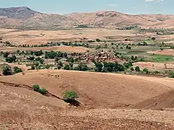 Anosivola, a fokontany of Mangidy | |
 Ikalamavony (district) Location in Madagascar | |
| Coordinates: 21°09′S 46°35′E | |
| Country | |
| Region | Haute Matsiatra |
| District | Ikalamavony |
| Area | |
| • Total | 10,163 km2 (3,924 sq mi) |
| Elevation | 799 m (2,621 ft) |
| Population (2018) | |
| • Total | 151,056 |
| Time zone | UTC3 (EAT) |
| Postal code | 314 |
Geography
The district is situated at 96 km north-west of Fianarantsoa.[3] Its main town, Ikalamavony is situated on the National road 42.
Communes
The district is further divided into eight communes:
- Ambatomainty - (45 km from Ikalamavony)
- Fitampito - (50 km from Ikalamavony)
- Ikalamavony
- Mangidy - (35 km from Ikalamavony)
- Solila - (46 km from Ikalamavony)
- Tanamarina Sakay
- Tanamarina (also named Tanamarina Bekisopa)
- Tsitondroina
Roads
The partly unpaved National road 42 links the town to Isorana and Fianarantsoa (90 km).[4]

Madagascar National Road 42
Rivers
Matsiatra in the North, and the Mananantanana river in the South cross the district. The Zomandao river is another river of importance.
References
Capital: Fianarantsoa | ||
| Ambalavao (17) - 303 | 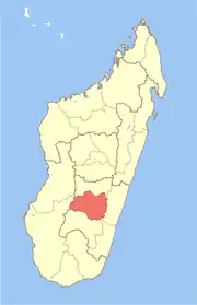 | |
| Ambohimahasoa (17) - 305 | ||
| Fianarantsoa (1) - 301 | ||
| Ikalamavony (8) - 314 | ||
| Isandra (13) - 314 | ||
| Lalangina (13) - 303 | ||
| Vohibato (15) - 305 | ||
Total: 7 districts; 84 communes | ||
This article is issued from Wikipedia. The text is licensed under Creative Commons - Attribution - Sharealike. Additional terms may apply for the media files.