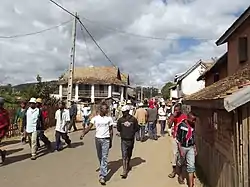
Talata Ampano
Talata Ampano is a rural municipality in Madagascar. It belongs to the district of Vohibato District, which is a part of Haute Matsiatra Region. The population of the commune was estimated to be approximately 15,000 in 2001 commune census.[3]
Talata Ampano | |
|---|---|
 Talata Ampano | |
 Talata Ampano Location in Madagascar | |
| Coordinates: 21°33′S 47°2′E | |
| Country | |
| Region | Haute Matsiatra |
| District | Vohibato District |
| Government | |
| • Mayor | Fidèle Ramanantsalama[1] |
| Elevation | 1,124 m (3,688 ft) |
| Population (2001)[3] | |
| • Total | 15,000 |
| Time zone | UTC3 (EAT) |
| Postal code | 305 |
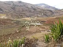
Primary and junior level secondary education are available in town. The majority 86% of the population of the commune are farmers, while an additional 5% receives their livelihood from raising livestock. The most important crop is rice, while other important products are vegetables, cassava, sweet potatoes and tomato. Industry and services provide employment for 6% and 2% of the population, respectively. Additionally fishing employs 1% of the population.[3]
Roads
The commune is crossed by the RN 7. It is situated at 18 km from Fianarantsoa.
References and notes
- Newsmada
- Estimated based on DEM data from Shuttle Radar Topography Mission
- "ILO census data". Cornell University. 2002. Retrieved 1 May 2008.
Capital: Fianarantsoa | ||
| Ambalavao (17) - 303 | 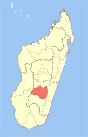 | |
| Ambohimahasoa (17) - 305 | ||
| Fianarantsoa (1) - 301 | ||
| Ikalamavony (8) - 314 | ||
| Isandra (13) - 314 | ||
| Lalangina (13) - 303 | ||
| Vohibato (15) - 305 | ||
Total: 7 districts; 84 communes | ||