Hlubočany
Hlubočany (German: Hobitschau) is a municipality and village in Vyškov District in the South Moravian Region of the Czech Republic. It has about 500 inhabitants.
Hlubočany | |
|---|---|
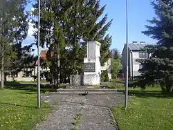 Memorial to the victims of the world wars | |
 Flag  Coat of arms | |
 Hlubočany Location in the Czech Republic | |
| Coordinates: 49°13′50″N 17°0′1″E | |
| Country | |
| Region | South Moravian |
| District | Vyškov |
| First mentioned | 1141 |
| Area | |
| • Total | 8.06 km2 (3.11 sq mi) |
| Elevation | 273 m (896 ft) |
| Population (2023-01-01)[1] | |
| • Total | 540 |
| • Density | 67/km2 (170/sq mi) |
| Time zone | UTC+1 (CET) |
| • Summer (DST) | UTC+2 (CEST) |
| Postal code | 682 01 |
| Website | hlubocany |
Hlubočany lies approximately 4 kilometres (2 mi) south of Vyškov, 28 km (17 mi) east of Brno, and 208 km (129 mi) south-east of Prague.
Administrative parts
The village of Terešov is an administrative part of Hlubočany.
History
The first written mention of Hlubočany is from 1141.[2]
Until 1945, Hlubočany and Terešov belonged to the German-speaking enclave called Vyškov Language Island. The area was colonized by German settlers in the second half of the 13th century. The coexistence of Czechs and Germans was mostly peaceful, which changed only after 1935, when many Germans tended to Nazism. In 1945, the German population was expelled and the municipality was resettled by Czech families.[2][3]
References
- "Population of Municipalities – 1 January 2023". Czech Statistical Office. 2023-05-23.
- "Vítejte" (in Czech). Obec Hlubočany. Retrieved 2022-01-12.
- "S památníkem německým starousedlíkům si Vyškov zatím neví rady" (in Czech). iDNES.cz. 2012-03-05. Retrieved 2022-01-12.