Radslavice (Vyškov District)
Radslavice is a municipality and village in Vyškov District in the South Moravian Region of the Czech Republic. It has about 400 inhabitants.
Radslavice | |
|---|---|
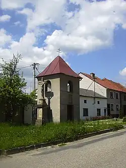 Belfry | |
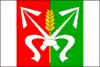 Flag  Coat of arms | |
 Radslavice Location in the Czech Republic | |
| Coordinates: 49°19′23″N 17°0′14″E | |
| Country | |
| Region | South Moravian |
| District | Vyškov |
| First mentioned | 1381 |
| Area | |
| • Total | 4.35 km2 (1.68 sq mi) |
| Elevation | 330 m (1,080 ft) |
| Population (2023-01-01)[1] | |
| • Total | 440 |
| • Density | 100/km2 (260/sq mi) |
| Time zone | UTC+1 (CET) |
| • Summer (DST) | UTC+2 (CEST) |
| Postal code | 683 21 |
| Website | www |
Radslavice lies approximately 6 kilometres (4 mi) north of Vyškov, 31 km (19 mi) north-east of Brno, and 205 km (127 mi) south-east of Prague.
Administrative parts
The village of Radslavičky is an administrative part of Radslavice.
This article is issued from Wikipedia. The text is licensed under Creative Commons - Attribution - Sharealike. Additional terms may apply for the media files.