Horní Město
Horní Město (German: Bergstadt) is a municipality and village in Bruntál District in the Moravian-Silesian Region of the Czech Republic. It has about 800 inhabitants.
Horní Město | |
|---|---|
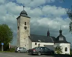 Church of Saint Mary Magdalene | |
 Flag  Coat of arms | |
 Horní Město Location in the Czech Republic | |
| Coordinates: 49°54′30″N 17°12′40″E | |
| Country | |
| Region | Moravian-Silesian |
| District | Bruntál |
| First mentioned | 1351 |
| Area | |
| • Total | 31.63 km2 (12.21 sq mi) |
| Elevation | 675 m (2,215 ft) |
| Population (2023-01-01)[1] | |
| • Total | 816 |
| • Density | 26/km2 (67/sq mi) |
| Time zone | UTC+1 (CET) |
| • Summer (DST) | UTC+2 (CEST) |
| Postal code | 793 44 |
| Website | www |
Administrative parts
Villages of Dobřečov, Rešov, Skály and Stříbrné Hory are administrative parts of Horní Město.
Etymology
The original German name Bergstadt means "mountain town". The Czech name was derived from the German name and means literally "mining town".
Geography
Horní Město lies about 20 kilometres (12 mi) southwest of Bruntál and about 34 kilometres (21 mi) north of Olomouc. The municipality is located on the border between the Nízký Jeseník and Hrubý Jeseník mountain ranges. The Huntava Stream flows through the municipality.
History
The first written mention of Horní Město is from 1398, when a settlement called Hankštejn/Hangstein was located here. Silver mining in the area was first documented in 1402, later gold and non-ferrous metals were also mined. In 1580, a free imperial town was founded by Emperor Rudolf II and was named Bergstadt - Hangstein. Later the second part of the name was dropped.[2]
From 1938 to 1945 it was annexed by Nazi Germany and administered as a part of Reichsgau Sudetenland. After the war, the German population was expelled.
In the middle of the 20th century, the last gold was mined and only non-ferrous metals remained. Their mining ended in 1970.[2]
Demographics
|
|
| ||||||||||||||||||||||||||||||||||||||||||||||||||||||
| Source: Censuses[3][4] | ||||||||||||||||||||||||||||||||||||||||||||||||||||||||
Sights
The Church of Saint Mary Magdalene was built in 1611. It is decorated by valuable paintings from 1690.[2]
References
- "Population of Municipalities – 1 January 2023". Czech Statistical Office. 2023-05-23.
- "Historie" (in Czech). Obec Horní Město. Retrieved 2022-03-15.
- "Historický lexikon obcí České republiky 1869–2011 – Okres Krnov" (in Czech). Czech Statistical Office. 2015-12-21. pp. 3–4.
- "Population Census 2021: Population by sex". Public Database. Czech Statistical Office. 2021-03-27.