Itahari
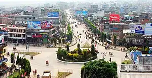
Itahari (Nepali: ईटहरी) is a sub-metropolitan city in the Sunsari District of Koshi Province of Nepal. Itahari city is the business hub of eastern Nepal. It is the second most populous city in Eastern Nepal after Biratnagar. Situated at a distance of 25 kilometres north of the provincial capital of Biratnagar, 16 kilometres south of Dharan and 92 kilometres west of Kakarbhitta, Itahari serves as a junction point of the east-west Mahendra Highway and the north–south Koshi Highway. Itahari has an estimated city population of 1,98,098 living in 40,207 households as per 2021 Nepal census. It is one of the fastest growing cities of Eastern Nepal. It is one of the cities of the Greater Birat Development Area which incorporates the cities of Biratnagar-Itahari-Gothgau-Biratchowk-Dharan[1] primarily located on the Koshi Highway in Eastern Nepal, with an estimated total urban agglomerated population of 804,300 people living in 159,332 households.[2]

Itahari
ईटहरी | |
|---|---|
 Itahari | |
 Itahari Location of Itahari in Koshi Province  Itahari Itahari (Nepal) | |
| Coordinates: 26°39′47″N 87°16′28″E | |
| Country | |
| Province | Koshi Province |
| District | Sunsari District |
| Wards | 20 |
| Settled | - |
| Government | |
| • Type | Mayor-council |
| • Mayor | Hem Karna Paudel (Congress) |
| • Deputy Mayor | Sangita Kumari Chaudhary(UML) |
| Area | |
| • Total | 36.21 sq mi (93.78 km2) |
| Population (2021) | |
| • Total | 198,098 |
| • Rank | 9th (Nepal) 2nd (Province No. 1) |
| • Density | 5,500/sq mi (2,100/km2) |
| • Ethnicities | Bahun Chhetri Tamang Limbu Rai Tharu Magars Newars |
| Languages | |
| • Official | Nepali |
| Time zone | UTC+5:45 (NST) |
| Postal Code | 56705 |
| Area code | 025 |
| Climate | Cwa |
| Website | itaharimun |
According to the Ministry of Federal Affairs and Local Development, Itahari has an area of 93.78 square kilometres (36.21 sq mi) with 140,517 people living in 33,794 individual households as of Census of Nepal 2011.[3][4][5][6] The town is divided into a total of 20 wards.[3] The municipality was established in 1997 and became a sub-metro in 2014 after merging the VDCs of Khanar, Ekamba, Pakali and Hansposa.[6][3]
Transportation
Itahari is a fast-growing town in eastern Nepal. .It is situated in a fertile plain. Located at the main transportation junction in eastern Nepal, the town is gaining importance as a traffic hub.[7] Being at the junction of the Mahendra Highway and the Koshi Highway, the town is of emerging importance.[8] Itahari is 30 kilometres (19 mi) at distance from Jogbani,[9] India by road which connects Itahari to Kolkata seaport by road and rail both means of transportation.
Biratnagar Airport is the nearest airport which is situated at 23 km distance from Itahari. Itahari is the junction of eastern development region.
Weather
In the winter season, the temperature of Itahari is 10–18 °C, it increases to 30–42 °C during the summer season.[10][11] About 2007 mm of precipitation falls annually. There is 4 mm of precipitation in December. In July, the precipitation reaches its peak, with an average of 571 mm.[12]
| Month | Jan | Feb | Mar | Apr | May | Jun | Jul | Aug | Sep | Oct | Nov | Dec | Year |
|---|---|---|---|---|---|---|---|---|---|---|---|---|---|
| Average high °C (°F) | 22.7 (72.9) |
26.1 (79.0) |
30.9 (87.6) |
33.9 (93.0) |
33.3 (91.9) |
32.9 (91.2) |
32.1 (89.8) |
32.5 (90.5) |
32.1 (89.8) |
31.6 (88.9) |
29.3 (84.7) |
25.4 (77.7) |
30.2 (86.4) |
| Daily mean °C (°F) | 15.8 (60.4) |
18.6 (65.5) |
23.3 (73.9) |
27.1 (80.8) |
28.3 (82.9) |
29.0 (84.2) |
28.8 (83.8) |
29.2 (84.6) |
28.4 (83.1) |
26.4 (79.5) |
22.3 (72.1) |
18.0 (64.4) |
24.6 (76.3) |
| Average low °C (°F) | 9.0 (48.2) |
11.1 (52.0) |
15.6 (60.1) |
20.4 (68.7) |
23.3 (73.9) |
25.2 (77.4) |
25.6 (78.1) |
25.8 (78.4) |
24.7 (76.5) |
21.1 (70.0) |
15.3 (59.5) |
10.5 (50.9) |
19.0 (66.2) |
| Average precipitation mm (inches) | 11.7 (0.46) |
13.2 (0.52) |
13.2 (0.52) |
53.1 (2.09) |
186.0 (7.32) |
302.4 (11.91) |
530.8 (20.90) |
378.3 (14.89) |
298.8 (11.76) |
91.8 (3.61) |
5.9 (0.23) |
6.6 (0.26) |
1,891.8 (74.47) |
| Source: Department of Hydrology and Meteorology (Nepal)[13] | |||||||||||||
Education
- Itahari International College
- Sushma Godawari College
- Itahari Namuna College
- Green Peace Lincoln College
- Koshi St.James Secondary School and College
- Vishwa Adarsha Secondary School and College
- Kasturi Academy
- Shri Janta Secondary School and College
- Garden Academy
- Rastriya Janasahayog College
- Shree Janasahayog Higher Secondary School
Demographics
Languages
language in itahari
At the time of the 2011 Census of Nepal, 52% of the population in the City spoke Nepali, 19% Tharu, 8% Maithili, 3% Rai, 2% Urdu, 2% Limbu, and 13% spoke other languages as their first language.[14]
Local Level Election
Local Level Election 2079
| Party | Mayor/Chairperson | Deputy Mayor/Chairperson | Results |
|---|---|---|---|
| Nepali Congress | Hem Karna Poudel | - | |
| CPN (Unified Marxist–Leninist) | Yam Kumar Chungwang Subba | Sangita Kumari Chaudhari | |
| Communist Party of Nepal (Maoist Centre) | - | - | |
| Communist Party of Nepal (Unified Socialist) | - | Keshav Kumar Bista | |
| Rastriya Prajatantra Party | Akash Hang Limbu | Babita Kumari Chaudhari | |
| CPN Maoist Socialist | Bhanu Bhakta Koirala | - | |
| Janata Samajwadi Party | Dilli Prasad Limbu | Yamuna Guragain | |
| Khambuwan Rastriya Morcha Nepal | Desh Maya Rai | - | |
| Maulik Jarokilo Party | Rameswar Thapa | Sharmila Baral | |
| Sanghiya Loktantrik Rastriya Manch | Bhim Kumar Limbu | Dilita Limbu | |
| Nagarik Unmukti Party | Akshay Kumar Chaudhari | - | |
| Mangol National Organization | Dipendra Rai | - | |
| Loktantrit Samajwadi Party | Ganga Bahadur Shrestha | - | |
| Independents | Jhamak Bahadur Karki | - | |
| Independents | Dilli Ram Dahal | - | |
| Independents | Padam Kumar Adhikari | - | |
| Independents | Tek Raj Bhujel | - | |
| Independents | - | Anju Kumari Singh |
Notable people
- Ritesh Thapa, a national level football player[15]
References
- "Capital of Province 1 to be scattered in various districts - myRepublica - the New York Times Partner, Latest news of Nepal in English, Latest News Articles". myrepublica.nagariknetwork.com. Archived from the original on 13 May 2021. Retrieved 14 March 2022.
- "Census Nepal 2021". censusnepal.cbs.gov.np. Archived from the original on 27 January 2022. Retrieved 22 February 2022.
- "स्थानीय तहहरुको विवरण". www.mofald.gov.np/en. MoFALD. Archived from the original on 31 August 2018. Retrieved 16 April 2018.
- "CITY POPULATION – statistics, maps & charts". www.citypopulation.de. 8 October 2017. Archived from the original on 16 April 2018. Retrieved 16 April 2018.
- "Itahari Sub-Metropolitan City Office (Government of Nepal)". itaharimun.gov.np. 14 January 2018. Archived from the original on 15 January 2018. Retrieved 14 January 2018.
- "Itahari Sub Metropolitan City". nepaloutlook.com. 14 January 2018. Archived from the original on 15 January 2018. Retrieved 14 January 2018.
- "A small town gaining importance due to its location at a highway junction". www.sos-childrensvillages.org. Archived from the original on 2 May 2018. Retrieved 2 May 2018.
- "Itahari". www.uan-networks.com. Archived from the original on 2 May 2018. Retrieved 2 May 2018.
- "Distance between Jogbani, India and Ithari, Nepal". www.distancesandcities.com. Archived from the original on 2 May 2018. Retrieved 2 May 2018.
- "Archived copy" (PDF). Archived from the original (PDF) on 4 March 2016. Retrieved 29 April 2018.
{{cite web}}: CS1 maint: archived copy as title (link) - Itahari Monthly Climate Averages, archived from the original on 29 April 2018, retrieved 28 April 2018
- "Climate: Itahari". www.climate-data.org. Archived from the original on 29 April 2018. Retrieved 29 April 2018.
- "Normals from 1985-2017" (PDF). Department of Hydrology and Meteorology (Nepal). Archived (PDF) from the original on 19 August 2019. Retrieved 20 October 2012.
- "NepalMap profile: itahari Sub-Metropolitan City". NepalMap. Retrieved 15 July 2022.
- Itahari at National-Football-Teams.com
