Křižánky
Křižánky is a municipality in Žďár nad Sázavou District in the Vysočina Region of the Czech Republic. It has about 400 inhabitants. Most of the built-up area with well preserved folk architecture is protected by law as a village monument reservation.
Křižánky | |
|---|---|
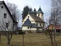 Church of Our Lady of Help | |
 Flag  Coat of arms | |
 Křižánky Location in the Czech Republic | |
| Coordinates: 49°41′9″N 16°3′53″E | |
| Country | |
| Region | Vysočina |
| District | Žďár nad Sázavou |
| First mentioned | 1392 |
| Area | |
| • Total | 11.97 km2 (4.62 sq mi) |
| Elevation | 615 m (2,018 ft) |
| Population (2023-01-01)[1] | |
| • Total | 394 |
| • Density | 33/km2 (85/sq mi) |
| Time zone | UTC+1 (CET) |
| • Summer (DST) | UTC+2 (CEST) |
| Postal code | 592 02 |
| Website | www |
Administrative parts
The municipality is made up of villages of České Křižánky, České Milovy and Moravské Křižánky.
Geography
Křižánky is located about 16 kilometres (10 mi) northeast of Žďár nad Sázavou and 64 km (40 mi) northwest of Brno. The municipality lies on both banks of the Svratka River, which forms the border between the historical lands of Bohemia and Moravia. The Kyšperský stream, which flows into the Svratka in the municipality, supplies the relatively large Kyšperský pond.
Křižánky is located in the Upper Svratka Highlands and within the Žďárské vrchy Protected Landscape Area. The mountain Devět skal, which is with an elevation of 836 metres (2,743 ft) the highest peak of the Upper Svratka Highlands and the second highest peak of the Bohemian-Moravian Highlands, is located in the municipal territory.
History
The first written mention of Křižánky is from 1392.[2]
Sights
The Church of Our Lady of Help was built in 1932–1934.[3]
Notable people
- František Cína Jelínek (1882–1961), landscape painter; lived and worked here
References
- "Population of Municipalities – 1 January 2023". Czech Statistical Office. 2023-05-23.
- "Symboly obce" (in Czech). Obec Křižánky. Retrieved 2022-04-25.
- "Kostel" (in Czech). Obec Křižánky. Retrieved 2022-06-17.