Matějov
Matějov is a municipality and village in Žďár nad Sázavou District in the Vysočina Region of the Czech Republic. It has about 200 inhabitants.
Matějov | |
|---|---|
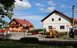 Centre of Matějov | |
 Flag  Coat of arms | |
 Matějov Location in the Czech Republic | |
| Coordinates: 49°31′43″N 15°51′47″E | |
| Country | |
| Region | Vysočina |
| District | Žďár nad Sázavou |
| First mentioned | 1366 |
| Area | |
| • Total | 9.82 km2 (3.79 sq mi) |
| Elevation | 590 m (1,940 ft) |
| Population (2023-01-01)[1] | |
| • Total | 196 |
| • Density | 20/km2 (52/sq mi) |
| Time zone | UTC+1 (CET) |
| • Summer (DST) | UTC+2 (CEST) |
| Postal code | 592 12 |
| Website | www |
Geography
Matějov is located about 6 kilometres (4 mi) southwest of Žďár nad Sázavou and 24 km (15 mi) northeast of Jihlava. It lies in the Křižanov Highlands. The highest point is at 632 m (2,073 ft) above sea level. The Oslava River originates in the municipal territory.
A notable body of water is the Matějovský Pond with an area of 60.4 ha (149 acres). The 80.8 ha (200-acre) large Veselský Pond is located just beyond the municipal border.[2]
References
- "Population of Municipalities – 1 January 2023". Czech Statistical Office. 2023-05-23.
- "Povodňový plán SO ORP Žďár nad Sázavou: Vodní díla". Elektronický digitální povodňový plán (in Czech). Retrieved 2023-09-12.
This article is issued from Wikipedia. The text is licensed under Creative Commons - Attribution - Sharealike. Additional terms may apply for the media files.