Sejřek
Sejřek is a municipality and village in Žďár nad Sázavou District in the Vysočina Region of the Czech Republic. It has about 200 inhabitants.
Sejřek | |
|---|---|
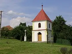 Chapel of Saint Anne | |
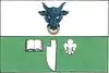 Flag 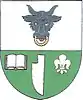 Coat of arms | |
 Sejřek Location in the Czech Republic | |
| Coordinates: 49°26′10″N 16°18′33″E | |
| Country | |
| Region | Vysočina |
| District | Žďár nad Sázavou |
| First mentioned | 1350 |
| Area | |
| • Total | 7.51 km2 (2.90 sq mi) |
| Elevation | 518 m (1,699 ft) |
| Population (2023-01-01)[1] | |
| • Total | 171 |
| • Density | 23/km2 (59/sq mi) |
| Time zone | UTC+1 (CET) |
| • Summer (DST) | UTC+2 (CEST) |
| Postal code | 592 62 |
| Website | www |
Administrative parts
The village of Bor is an administrative part of Sejřek.
Geography
Sejřek is located about 30 kilometres (19 mi) southeast of Žďár nad Sázavou and 31 km (19 mi) northwest of Brno. It lies in the Upper Svratka Highlands. The highest point is at 581 m (1,906 ft) above sea level. The Nedvědička River flows along the northern municipal border.
History
The first written mention of Sejřek is from 1350. For centuries it was part of the Pernštejn estate.[2]
Sights
There are no protected cultural monuments in the municipality.[3] A landmark is the Chapel of Saint Anne is the centre of Sejřek. It dates from 1876.[2]
Notable people
- Jiří Krytinář (1947–2015), actor
References
- "Population of Municipalities – 1 January 2023". Czech Statistical Office. 2023-05-23.
- "Obec – historie" (in Czech). Obec Sejřek. Retrieved 2023-09-19.
- "Výsledky vyhledávání: Kulturní památky, obec Sejřek". Ústřední seznam kulturních památek (in Czech). National Heritage Institute. Retrieved 2023-09-19.
This article is issued from Wikipedia. The text is licensed under Creative Commons - Attribution - Sharealike. Additional terms may apply for the media files.