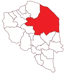
Kerman County
Kerman County (Persian: شهرستان کرمان) is in Kerman province, Iran. Its capital is the city of Kerman.
Kerman County
Persian: شهرستان کرمان | |
|---|---|
County | |
 Location of Kerman County in Kerman province | |
 Location of Kerman province in Iran | |
| Coordinates: 30°29′N 57°57′E[1] | |
| Country | |
| Province | Kerman |
| Capital | Kerman |
| Districts | Central, Chatrud, Golbaf, Mahan, Rayen, Shahdad |
| Population (2016)[2] | |
| • Total | 738,724 |
| Time zone | UTC+3:30 (IRST) |
| Kerman County can be found at GEOnet Names Server, at this link, by opening the Advanced Search box, entering "9206706" in the "Unique Feature Id" form, and clicking on "Search Database". | |
At the 2006 census, the county's population was 654,052 in 166,740 households.[3] The following census in 2011 counted 722,484 people in 199,138 households.[4] At the 2016 census, the county's population was 738,724 in 222,356 households.[2] It is the largest county in the province by area.
Administrative divisions
The population history of Kerman County's administrative divisions over three consecutive censuses is shown in the following table. The latest census shows six districts, 16 rural districts, and 13 cities.[2]
| Administrative Divisions | 2006[3] | 2011[4] | 2016[2] |
|---|---|---|---|
| Central District | 557,236 | 612,577 | 625,187 |
| Baghin RD | 4,867 | 4,652 | 4,279 |
| Derakhtenagan RD | 6,847 | 9,383 | 12,662 |
| Ekhtiarabad RD | 13,974 | 25,391 | 25,407 |
| Sar Asiab-e Farsangi RD | 1,631 | 1,593 | 1,935 |
| Zangiabad RD | 11,438 | 13,372 | 14,371 |
| Baghin (city) | 7,616 | 8,176 | 10,407 |
| Ekhtiarabad (city) | 7,513 | 8,746 | 9,840 |
| Kerman (city) | 496,684 | 534,441 | 537,718 |
| Zangiabad (city) | 6,666 | 6,823 | 8,568 |
| Chatrud District | 24,678 | 26,961 | 31,183 |
| Kavirat RD | 8,737 | 10,885 | 13,216 |
| Moezziyeh RD | 6,669 | 7,087 | 8,047 |
| Chatrud (city) | 5,660 | 5,344 | 5,860 |
| Kazemabad (city) | 3,612 | 3,645 | 4,060 |
| Golbaf District | 12,979 | 12,912 | 14,473 |
| Jowshan RD | 2,583 | 2,007 | 2,956 |
| Keshit RD | 2,055 | 2,077 | 2,312 |
| Golbaf (city) | 8,341 | 8,828 | 9,205 |
| Mahan District | 29,923 | 31,319 | 33,521 |
| Mahan RD | 3,364 | 3,560 | 4,008 |
| Qanatghestan RD | 2,449 | 2,925 | 2,553 |
| Jupar (city) | 3,830 | 3,937 | 3,607 |
| Mahan (city) | 16,787 | 17,178 | 19,423 |
| Mohiabad (city) | 3,493 | 3,719 | 3,930 |
| Rayen District | 13,903 | 18,050 | 15,672 |
| Hoseynabad-e Goruh RD | 2,085 | 3,274 | 2,588 |
| Rayen RD | 2,195 | 3,770 | 2,798 |
| Rayen (city) | 9,623 | 11,006 | 10,286 |
| Shahdad District | 15,333 | 20,665 | 18,651 |
| Anduhjerd RD | 915 | 1,309 | 1,313 |
| Sirch RD | 2,600 | 3,549 | 2,190 |
| Takab RD | 4,868 | 6,276 | 5,890 |
| Anduhjerd (city) | 2,853 | 3,589 | 4,041 |
| Shahdad (city) | 4,097 | 5,942 | 5,217 |
| Total | 654,052 | 722,484 | 738,724 |
| RD: Rural District | |||
Wikimedia Commons has media related to Kerman County.
References
- OpenStreetMap contributors (30 June 2023). "Kerman County" (Map). OpenStreetMap. Retrieved 30 June 2023.
- "Census of the Islamic Republic of Iran, 1395 (2016)". AMAR (in Persian). The Statistical Center of Iran. p. 08. Archived from the original (Excel) on 20 October 2020. Retrieved 19 December 2022.
- "Census of the Islamic Republic of Iran, 1385 (2006)". AMAR (in Persian). The Statistical Center of Iran. p. 08. Archived from the original (Excel) on 20 September 2011. Retrieved 25 September 2022.
- "Census of the Islamic Republic of Iran, 1390 (2011)" (Excel). Iran Data Portal (in Persian). The Statistical Center of Iran. p. 08. Retrieved 19 December 2022.
This article is issued from Wikipedia. The text is licensed under Creative Commons - Attribution - Sharealike. Additional terms may apply for the media files.
