Key Bridge (Washington, D.C.)
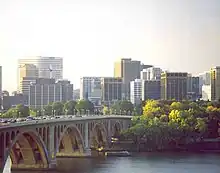
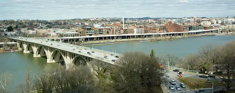
The Francis Scott Key Bridge, more commonly known as the Key Bridge, is a six-lane reinforced concrete arch bridge conveying U.S. Route 29 (US 29) traffic across the Potomac River between the Rosslyn neighborhood of Arlington County, Virginia, and the Georgetown neighborhood of Washington, D.C. Completed in 1923, it is Washington's oldest surviving road bridge across the Potomac River.
Key Bridge | |
|---|---|
| Coordinates | 38°54′08″N 77°04′11″W |
| Characteristics | |
| Clearance below | 60 feet (18 m)[1][2] |
Key Bridge | |
 Key Bridge in April 2006 | |
 | |
| Location | |
| Coordinates | 38°54′8″N 77°4′13″W |
| Built | 1923 |
| Architect | Nathan C. Wyeth Max C. Tyler |
| Architectural style | Classical Revival arch bridge 518.5 meters (1,701 ft) long |
| NRHP reference No. | 96000199[3] |
| VLR No. | DC Local |
| Significant dates | |
| Added to NRHP | March 1, 1996[4] |
| Designated DCIHS | November 8, 1964[5] |
| Designated VLR | October 18, 1995[6] |
| Location | |
Key Bridge was added to the National Register of Historic Places in 1996.
History
Deterioration of the Aqueduct Bridge
The Key Bridge replaced the older Aqueduct Bridge. The first Aqueduct Bridge was built in 1830 to carry the Chesapeake and Ohio Canal across the Potomac to connect with the Alexandria Canal on the Virginia shore. The bridge was converted into a roadway during the American Civil War. In 1866, the canal was restored and a new wooden roadway built over it atop trestles. The bridge was demolished down to its stone piers in 1884.
A second Aqueduct bridge, erected on the old piers, opened in 1889. Within a dozen years, proposals were being made to replace it.[7] These proposals were delayed after the 1902 release of the McMillan Plan, whose proposals for new Potomac bridges called into question whether Aqueduct Bridge should be replaced or merely torn down.[8] In the meantime, Congress approved repairs to the bridge in 1902[9] 1908,[10] and 1913.[11] In 1906, a cantilevered structure was added to support tracks for streetcars, which would operate on the bridge until it was closed in 1923.
The Carlin bill
In March 1914, Representative Charles Creighton Carlin of Virginia sponsored legislation to replace Aqueduct Bridge with a new, $1 million structure.[12] The Commissioners of the District of Columbia (the city's appointed government) approved the new bridge in June.[13] Controversy over the new bridge immediately broke out. Senator Claude A. Swanson, chairman of the Senate Committee on Public Works, wanted the new bridge built about 3,000 feet (910 m) downstream at the mouth of Rock Creek (at about 30th Street NW), where it would cross Analostan Island and the Potomac River to Rosslyn.[14] Georgetown merchants strongly opposed this plan.[15] There were some in Congress who wanted to repair the existing bridge, but a study by the United States Army Corps of Engineers in August 1914 showed that the existing structure was inadequate for the amount of traffic and too unstable to be saved.[11] Secretary of War Lindley Miller Garrison, who oversaw the Corps, agreed that a new bridge was necessary in December.[16] Rep. William C. Adamson, chairman of the House Committee on Public Works, challenged Swanson and declared that the new bridge should be placed where the old one was.[17]
The Carlin bill began moving through the House in January 1915. But House members balked at the cost.[18] Garrison tried to break the deadlock on January 9 by issuing a report that declared the existing bridge unsafe, and requesting that the new one be built in the same location.[19] The D.C. Commissioners said the location of the bridge was up to them,[20] and the Corps warned that not only could the existing bridge not be enlarged but agreed with Garrison that it was structurally unsound.[21] Swanson changed his mind, and agreed in January 1916 that the new bridge should be built on the existing site.[22] Garrison endorsed the Carlin bill on January 27.[23] On February 3, 1916, vehicular traffic over Aqueduct Bridge was limited by the city to a single automobile at a time due to its dangerous nature.[24] The House passed legislation appropriating $1.175 million for construction of a new bridge on March 6.[25] D.C. commissioners held hearings on the bridge site in late March, and approved the site in early April.[26] The Senate passed some minor amendments to the House bill, and after some legislative discussions and a conference committee, the Carlin bill passed Congress on May 2, 1916.[27] President Woodrow Wilson signed the legislation on May 19.[28]
Construction
.jpg.webp)
On June 1, 1916, the Army Corps of Engineers named the new bridge "Francis Scott Key Bridge," in honor of the man who had written the lyrics to the Star Spangled Banner whose home was just a few blocks from the bridge's abutment. Plans began to be drawn up at that time.[29]
The Classical Revival[30] bridge was designed by Nathan C. Wyeth, an architect in private practice in the city, and Major Max C. Tyler, an engineer with the Army Corps of Engineers.[31] The legislation authorizing the bridge's construction required that the United States Department of War consult with the United States Commission of Fine Arts (CFA) in the design of the bridge. Subsequently, the Chief of Engineers of the Army Corps of Engineers asked the CFA for a list of architects whom the CFA believed would be competent to design an aesthetically pleasing bridge. The CFA swiftly provided a list, and in July 1916 Tyler met with the CFA to discuss a short list of potential architects. The CFA and Tyler also conferred on the bridge's orientation, design, and approaches.[32] Tyler selected Wyeth.[33] The plans were nearly complete by September.[34] Wyeth and Tyler's initial design for the bridge was a double-deck structure with a single, high span. But with World War I erupting in Europe, inflation made this structure too costly. Wyeth then submitted a design for a single-deck, single-span bridge on January 12, 1917. The CFA asked Wyeth to design a multi-span bridge, or, failing that, to construct non-structural decorative elements that would make it look as if the bridge had multiple spans. Wyeth agreed, and the CFA approved the bridge design.[33][35]
In January 1917, the Corps of Engineers found that inflation in the price of construction materials made it necessary to ask for $300,000 more in funding from Congress.[36] Congress balked at paying.[37] But citizen pressure and the danger of Aqueduct Bridge's collapse due to ice flows in the spring[38] convinced Congress to pay the money.
Construction contracts were drawn up in late February,[39] and excavation work on the D.C. abutments began in March.[40] The first coffer dam for construction of the piers was sunk in May 1918,[41] and the old Aqueduct Bridge formally closed on July 9.[42] Immense amounts of concrete were needed to construct the bridge. One concrete mixing plant was constructed on the D.C. shore, and concrete was delivered to the worksite in the river by ropeway conveyor. A second mixing plant was constructed in mid-river: The plant was floated into position, and then allowed to sink down to the riverbed. Steel for the reinforced concrete structure and for the steel arches within its spans was assembled on the D.C. shoreline, then floated by barge to the worksite.[43] Progress was slow, as reinforced concrete was a relatively new type of construction.[44] The project ran out of money, and Tyler requested and won an additional $1.1 million from Congress in 1920 to finish the work.[43] Streetcar tracks were laid down the center of the bridge.
The new $2.35 million Key Bridge opened on January 17, 1923,[45] whereupon the old Aqueduct Bridge was finally closed. The federal government turned title to the new bridge over to the District of Columbia on November 15, 1924.[46] The Washington and Old Dominion Railway, which had operated streetcars across the Aqueduct Bridge, declined to operate on the new bridge. It ended service into the District of Columbia with the closure of the old bridge and built a new terminal in Rosslyn. Service from this terminal, across Key Bridge, and into D.C. was provided by the Capital Traction Company.[47]
The razing of the old Aqueduct Bridge began in December 1933, when its superstructure and most of the above-water portions of its piers were removed.[48] [49] The bases of the piers were retained to protect the Key Bridge from ice floes, but only one survives today. Its Washington and Virginia abutments survive just west of Key Bridge.[50]
Description

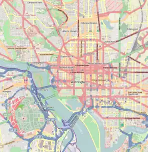
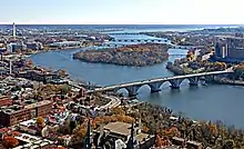
The Key Bridge spans the Potomac River, connecting the Georgetown neighborhood in the District of Columbia with the neighborhood of Rosslyn in Arlington County, Virginia.[52] Key Bridge is Washington's oldest existing road bridge across the Potomac River.[53]
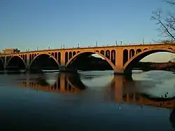
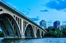
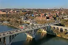
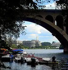
The bridge is an open-spandrel, arched[52][54] structure oriented in a north-south direction[55] and constructed of reinforced concrete and steel.[56] Each span consists of three steel arches: A center arch which is 22 feet (6.7 m) in width, and two outer arches each 11 feet (3.4 m) in width. To lighten the load on the span arches, the spandrels were filled with additional arches. Depending on the size of the span, there are either three or four spandrel arches. Together, the span arch and spandrel arches form a truss. The piers were decorated with pilasters in the Doric style.[55]
The northern terminus of the bridge is just east of the site of Francis Scott Key's home, which was dismantled in the late 1940s. A park honoring Key now occupies the site.[53][57] The bridge connects with M Street NW, Canal Road NW, and the Whitehurst Freeway (which provides access to K Street NW and downtown). The northbound span has an exit ramp to the eastbound Whitehurst Freeway; however, traffic from the westbound Whitehurst Freeway to the southbound span must use M Street.
The southern terminus of the bridge is in the state of Virginia. Northbound traffic accesses the bridge via North Lynn Street, with southbound traffic exits the bridge via North Fort Myer Drive. A cloverleaf ramp from southbound George Washington Memorial Parkway connects to northbound North Lynn Street just before the bridge. Southbound traffic may turn right onto an off-ramp leading to northbound George Washington Memorial Parkway. The bridge's southbound off-ramp connect with north/west-bound U.S. Route 29. Traffic wishing to access southbound Interstate 66 (the Custis Memorial Parkway) must do so by traversing local Rosslyn streets.
The bridge originally measured 1,450 feet (440 m) in length, with a roadway 85 feet (26 m) above the average water level.[58] The original road deck was 70 feet (21 m) wide.[58] It included two 16-foot (4.9 m) wide traffic lanes, a center lane with streetcar tracks,[55] and two 8-foot (2.4 m) wide sidewalks.[58] A horizontal, decorative molding ran along the outer edge of the bridge. It projected outward by 2 feet (0.61 m). Atop this cornice was a paneled parapet. The parapet (or railing) was 4 feet (1.2 m) high and 1 foot (0.30 m) thick. Between each baluster of the parapet is a 6-foot (1.8 m) recessed panel. Atop the parapet were street lights. These were made of cast iron, were 7-foot-1-inch (2.16 m) tall, and featured a griffin's leg and winged shield at the base. The light were spaced 40 feet (12 m) apart.[55]
The bridge had five arches when constructed. The central arch was 208 feet (63 m) long, and the two adjacent arches were 204 feet (62 m) long.[58] The shoreward arches were each 187 feet (57 m) long.[55] Separate spans completed the approaches to the bridge. The span over the Chesapeake and Ohio Canal in the District of Columbia was either 82 feet (25 m)[55] or 85 feet (26 m) long[58] (sources vary), while the span over K Street NW was 180 feet (55 m) long.[58] The original approach span on the Virginia side was 152 feet (46 m) long.[58]
Renovations and alterations
1939 alterations
Francis Scott Key Bridge was altered in 1938 when Congress extended the George Washington Memorial Parkway north along the Virginia shoreline past Key Bridge.[59] A new 152-foot (46 m) span over the parkway was added in 1939, giving the bridge an eighth span.[55][52] Sources vary significantly as to the bridge's new length, with estimates including 1,635 feet (498 m),[52] 1,781 feet (543 m),[54] 1,791 feet (546 m),[60] and 1,791 feet 6 inches (546.05 m).[55]
1955 alterations
Another major alteration to the bridge occurred in 1955. The District of Columbia was replacing streetcars with buses, and as part of this change the streetcar tracks over the bridge were torn out. The road deck was widened at this time as well to 80 feet (24 m), which allowed the roadway itself to be widened to 66 feet (20 m). A 2-foot (0.61 m) high guard rail was added between the roadway and the sidewalks, which necessitated narrowing the sidewalks to just 5 feet 3 inches (1.60 m). The parapet and original street lights were also removed. A steel railing was added on the external side of the sidewalks, and 30-foot (9.1 m) high "cobrahead" aluminum lampposts were installed every 120 feet (37 m).[61]
1987 alterations
An entirely new roadway deck was installed in 1986-87. The new road deck was a bonded post-tensioned concrete deck[54] 90 feet (27 m) in width.[62] The roadway width remained the same, but the extra deck width allowed the sidewalks to be widened to 9 feet 10 inches (3.00 m). The 1955 railing was removed, and a precast concrete parapet 2 feet 8 inches (0.81 m) high with 6-foot (1.8 m) recessed panels between the balusters was installed. The new parapet resembles the 1923 railing. Atop the new parapet is a 5-foot (1.5 m) high steel railing designed to act as a suicide prevention measure. The new steel railing has 0.75-inch (1.9 cm) wide bars set 4 inches (10 cm) apart. Type 16 Washington Upright Lampposts, each 14 feet (4.3 m) high, were installed above the apex of each arch and atop each pier.[62]
On March 1, 1996, the Key Bridge was added to the National Register of Historic Places.[4]
2014 rehabilitation

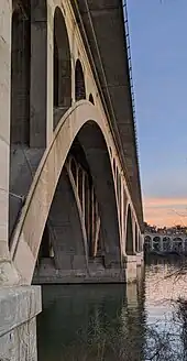
Key Bridge underwent a major inspection in 2011. Officials were concerned that the chemical agents used to bond the tensioned cables running through the concrete road deck were corroding the concrete. The architectural engineering firm of Johnson, Mirmiran & Thompson (JMT) was hired to inspect the bridge. JMT discovered that the deck slab was ready to fail, and there was extensive corrosive deterioration of the underside of the concrete deck.[54] Cracks were also found in some of the abutments, arches and spandrel arches, concrete deck, and piers.[60] The sonic echo/impulse response method was used to identify areas within the concrete where cables had disintegrated or where corrosion had created voids. JMT restored some deteriorated portions of the deck.[54] The bridge was rated "structurally deficient" after these tests.[63]
In 2013, Key Bridge carried about 62,000 vehicles each day.[60] The Washington Post in April 2014 called Key Bridge one of the three "busiest deficient bridges" in the District of Columbia, along with Arlington Memorial Bridge and the connection between Park Road and the Anacostia Freeway.[64]
The District of Columbia Department of Transportation (DDOT) announced a two-year, $21 million rehabilitation of the bridge in April 2014. In addition to repairing the previously-identified structural issues, the street lights were replaced with modern energy-efficient lampposts, the guard rail between the roadway and sidewalks was strengthened, the bridge's drainage system fixed and improved, and the bridge painted.[60]
2016 rehabilitation
A second round of rehabilitation work on Key Bridge was scheduled for fall 2015,[65] although the contract was not announced until October 2015, delaying work about six months. The two-year, $30 million project was intended to replace more street lights with modern fixtures, strengthen the deck overhangs on both sides of the bridge, repair the concrete deck beneath the roadway, repair cracked and broken portions of the concrete superstructure, repair the reinforced concrete beams beneath the concrete deck, improve drainage, and clad the footings of the piers with "fiber-reinforced polymer jackets" to inhibit corrosion. The right lanes of the bridge is being treated with a resin as a test to see if the material will help reduce water infiltration and corrosion. Minor repairs and alterations will also improve pedestrian and bicycle safety on the ramp to the eastbound Whitehurst Freeway. These include removing bollards that narrow the sidewalk, and installing cameras that detect pedestrians and bicycles and will trigger flashing lights on the ramp to warn motorists about their presence.[66] Work began in October 2016 and was to last two years, but was still ongoing in August 2019.[67]
See also
 Transport portal
 Engineering portal
 Virginia portal
 United States portal
- List of bridges documented by the Historic American Engineering Record in Washington, D.C.
- List of bridges on the National Register of Historic Places in Virginia
- List of bridges on the National Register of Historic Places in Washington, D.C.
- National Register of Historic Places listings in Arlington County, Virginia
- National Register of Historic Places listings in Washington, D.C.
- Architecture of Washington, D.C.
References
- "Exploring Maps and Charts of Washington, Washington Channel, DC". Retrieved September 13, 2023.
- United States Coast Pilot. Atlantic Coast: Sandy Hook to Cape Henry. Vol. 3 (3rd ed.). 1930. p. 175.
- "National Register Information System". National Register of Historic Places. National Park Service. March 13, 2009.
- "District of Columbia - Inventory of Historic Sites" (PDF). Government of the District of Columbia. September 1, 2004. Archived from the original (PDF) on July 17, 2009. Retrieved July 17, 2009.
- "District of Columbia Inventory of Historic Sites" (PDF). D.C. Historic Preservation Review Board. September 30, 2009. p. 83. Retrieved October 30, 2019.
- "Virginia Landmarks Register". Virginia Department of Historic Resources. October 2014. Archived from the original on September 21, 2013. Retrieved May 12, 2013.
- "Plans for New Bridge". Washington Post. February 7, 1901.
- "Aqueduct Bill Report". Washington Post. March 8, 1902.
- "Bridge Plans Held Up". Washington Post. February 27, 1903; "Tracks on Aqueduct Bridge". Washington Post. March 1, 1903; "Contract for Bridge Pier". Washington Post. April 12, 1903; "Delay on Aqueduct Bridge". Washington Post. July 17, 1904.
- "Pier Nearing Completion". Washington Post. June 17, 1908; "Holes in Bridge Piers". Washington Post. October 15, 1908; "Bridge in Good Condition". Washington Post. October 16, 1908..
- "Wants A New Bridge". Washington Post. August 12, 1914..
- "To Push Bridge Bill". Washington Post. March 17, 1914.
- "Urge Bridge Improvement". Washington Post. March 19, 1914; "Approve Bridge Plan". Washington Post. June 20, 1914..
- "Wants 2 New Bridges". Washington Post. July 10, 1914.
- "Fights Bridge Change". Washington Post. July 13, 1914; "Near the Old Bridge". Washington Post. July 15, 1914..
- "Agree on New Bridge". Washington Post. December 25, 1914.
- "Adamson Declares Aqueduct Bridge Inadequate, Unsafe, and Unsightly". Washington Post. January 9, 1915.
- "Plead for New Bridge". Washington Post. January 9, 1915.
- "Finds Old Bridge Bad". Washington Post. January 10, 1915.
- "Aqueduct Plans Held Up". Washington Post. February 26, 1915.
- "Larger Bridge Loads Urged". Washington Post. October 29, 1915; "Old Bridge Is Unsafe". Washington Post. January 8, 1916.
- "Bridge Plea to Garrison". Washington Post. January 21, 1916.
- "Garrison For New Bridge". Washington Post. January 28, 1916.
- "Limits Aqueduct Traffic". Washington Post. February 4, 1916.
- "$1,000,000 For New Bridge". Washington Post. March 7, 1916.
- "Hearing on Bridge Monday". Washington Post. March 26, 1916; "Bridge Where It Is". Washington Post. April 6, 1916.
- "Credit for Aqueduct Bridge". Washington Post. May 3, 1916; "New Bridge Assured". Washington Post. May 3, 1916.
- "Signs Aqueduct Bridge Bill". Washington Post. May 20, 1916.
- "Ready to Draw Bridge Plans". Washington Post. June 2, 1916.
- Cardno, Catherine A. (July 2012). "Waterfront Bridge Project Eases D.C. Traffic". Civil Engineering. Archived from the original on April 26, 2014. Retrieved April 26, 2014.
- Myer 1974, p. 13.
- Commission of Fine Arts 1917, pp. 53–54.
- Commission of Fine Arts 1918, p. 48.
- "Hurry New Bridge Plans". Washington Post. September 10, 1916.
- Commission of Fine Arts 1920, p. 48.
- "Aqueduct Bridge Plea". Washington Post. January 25, 1917.
- "Balks at Bridge Cost". Washington Post. February 17, 1917.
- (1) "Citizens Want Bridge Now". Washington Post. February 19, 1917
(2) "Aqueduct Bridge's Danger Is Passed". Washington Post. February 20, 1917. - "Key Bridge Ready in 1919". Washington Post. February 28, 1917.
- "At Work For Key Bridge Abutment". Washington Post. March 29, 1918.
- "Key Coffer Dam Ready". Washington Post. May 12, 1918.
- "Order Bridge Closed". Washington Post. July 10, 1921.
- D.C. Historic Preservation Division 1995, Section 8, page 2.
- D.C. Historic Preservation Division 1995, Section 8, pages 1-2.
- "Key Bridge Is Opened". Washington Post. January 18, 1923.
- D.C. Historic Preservation Division 1995, Section 8, page 3.
- Harwood, Herbert H. Jr. (April 2000). Rails to the Blue Ridge: The Washington and Old Dominion Railroad, 1847 – 1968 (3rd ed.) (PDF).
- (1) "Danger Great On Span Job, CWA Warned". Washington Post. December 16, 1933
(2) "Civil Works Funds Used in Razing of Structure". Washington Post. December 26, 1933
(3) "Skilled Labor Razing Bridge Gets Pay Boost". Washington Post. December 27, 1933
(4) "Cold Wave Slows Razing of Bridge". Washington Post. December 30, 1933. - Goode 2003, p. 449.
- Carter, Elliot. "This Georgetown Bridge Was For Boats". Architect of the Capital: Hidden History of Washington, D.C. Archived from the original on February 5, 2017. Retrieved March 17, 2018.
- Barker, Karlyn; Chen, Vivien. "Landmarks Tell Lore of Watergate". The Washington Post. Archived from the original on August 11, 2016.
- Siegal, Ann Cameron (September 10, 2010). "Making Connections". Washington Post.
- Jackson 1988, pp. 113–114.
- "Francis Scott Key Bridge Rehabilitation over the Potomac River". Johnson, Mirmiran & Thompson. 2011. Archived from the original on April 26, 2014. Retrieved April 25, 2014.
- D.C. Historic Preservation Division 1995, Section 7, page 1.
- Scott & Lee 1993, p. 406.
- "New Memorials Update". National Park Service. March 14, 2001. Archived from the original on April 26, 2009. Retrieved July 17, 2009.
- Emery 1938, p. 57.
- Woodruff, William E. (November 27, 1938). "Expenditures May Reach $200,000,000". Washington Post.
- Neibauer, Michael (April 25, 2014). "Key Bridge to Undergo Two-Year, $21M Overhaul". Washington Business Journal. Archived from the original on May 16, 2014. Retrieved April 25, 2014.
- D.C. Historic Preservation Division 1995, Section 7, pages 1–2.
- D.C. Historic Preservation Division 1995, Section 7, page 2.
- Halsey III, Ashley (October 20, 2011). "215 Bridges in D.C. Area Seen As Deficient". Washington Post; Halsey III, Ashley (April 25, 2014). "63,000 Bridges Structurally Deficient, U.S. Says". Washington Post.
- Halsey III, Ashley (April 24, 2014). "U.S. Has 63,000 Bridges That Need Significant Repairs". Washington Post. Archived from the original on April 25, 2014. Retrieved April 26, 2014.
- Dildine, Dave (June 25, 2015). "DDOT details area's structurally deficient bridges". WTOP. Archived from the original on August 26, 2015. Retrieved September 1, 2015.
- Neibauer, Michael (October 7, 2015). "Key Bridge to undergo 2-year rehab, contractor sought". Washington Business Journal. Archived from the original on August 17, 2016. Retrieved October 7, 2015.
- "Key Bridge Rehabilitation Monthly Reports Construction Updates". Retrieved November 7, 2019.
Bibliography
- Commission of Fine Arts (1917). Report of the Commission of Fine Arts for the Fiscal Year Ended June 30, 1916. Washington, D.C.: Government Printing Office. hdl:2027/coo.31924106244548.
- Commission of Fine Arts (1918). Report of the Commission of Fine Arts. June 30, 1916 to January 1, 1918. Washington, D.C.: Government Printing Office. hdl:2027/coo.31924106244548.
- Commission of Fine Arts (1920). Report of the Commission of Fine Arts. Eighth Report January 1, 1918 to July 1, 1919. Washington, D.C.: Government Printing Office. hdl:2027/coo.31924106244548.
- D.C. Historic Preservation Division (December 19, 1995). Francis Scott Key Bridge. National Register of Historic Places Registration Form. NPS Form 10-900 (Rev. 10-90) (PDF) (Report). National Park Service. United States Department of the Interior. Retrieved April 25, 2014.
- Emery, Fred A. (1938). "Washington's Historic Bridges". Records of the Columbia Historical Society, Washington, D.C.: 49–70.
- Goode, James M. (2003). Capital Losses: A Cultural History of Washington's Destroyed Buildings. Washington, D.C.: Smithsonian Books. ISBN 9781588341051.
- Jackson, Donald C. (1988). Great American Bridges and Dams: A National Trust Guide. Hoboken, N.J.: John Wiley and Sons. ISBN 0471143855.
- Myer, Donald Beekman (1974). Bridges and the City of Washington. Washington, D.C.: U.S. Commission of Fine Arts.
- Scott, Pamela; Lee, Antoinette Josephine (1993). Buildings of the District of Columbia. Oxford, U.K.: Oxford University Press. ISBN 0195061462.
External links
- Historic American Engineering Record (HAER) No. DC-51, "Francis Scott Key Bridge"
- Francis Scott Key Bridge at Structurae
