Khaliajuri Upazila
Khaliajuri (Bengali: খালিয়াজুড়ি) is an upazila (sub-district) of the Netrokona District in Bangladesh, part of the Mymensingh Division.[1]
Khaliajuri
খালিয়াজুড়ি | |
|---|---|
 Khaliajuri Location in Bangladesh | |
| Coordinates: 24°42′N 91°7.5′E | |
| Country | |
| Division | Mymensingh Division |
| District | Netrokona District |
| Thana | 1906 |
| Upazila | 1983 |
| Government | |
| • Upazila Chairman | Ghulam Kibria Jabbar |
| • MP (Netrokona-4) | Rebecca Momin |
| Area | |
| • Total | 297.64 km2 (114.92 sq mi) |
| Population (2011) | |
| • Total | 97,450 |
| • Density | 330/km2 (850/sq mi) |
| Time zone | UTC+6 (BST) |
| Website | khaliajuri |
History
Until the middle of the fourteenth century AD, the Bhati Rajya (Khaliajuri and surrounding areas) was the capital of Kamarupa. In the fourteenth century, a Kshatriya monk named Jitari invaded and occupied Bhati Rajya. Another Kshatriya monk named Lambodar came took over the rule of Bhati in the twelfth century.[2] Nagendranath Basu asserts that Lambodar and Jitari may have been the same person.[3]
In the 16th-century, Khaliajuri was home to a Bengali Hindu man called Shitanath Om. His three sons; Raghunath Om, Kamakhya Om and Maheshnath Om, later found employment under Khwaja Usman of Bokainagar, a Baro-Bhuiyan chief who had control over large parts of Greater Mymensingh. Following the defeat of Raja Subid Narayan of Ita by Khwaja Usman and his allies which included the Om family, the Om brothers migrated to Satgaon in Sreemangal, Sylhet where they were given jagir.[4]
In 1906, a thana (police outpost) was established in Khaliajuri. Khaliajuri Thana's status was upgraded to upazila (sub-district) in 1983 as part of the President of Bangladesh Hussain Muhammad Ershad's decentralisation programme.
Geography
Khaliajuri is located at 24.7000°N 91.1250°E. It has 12903 households and total area 297.64 km2 (114.92 sq mi). It is bounded by Mohanganj and Jamalganj upazilas on the north, Itna upazila on the south, Sulla and Derai upazilas on the east, Madan upazila on the west.[1]
Demographics
According to 2011 Bangladesh census, Khaliajuri had a population of 97,450. Males constituted 51.10% of the population and females 48.90%. Muslims formed 66.43% of the population, Hindus 33.54%, Christians 0.02%, and others 0.02%. Khaliajuri had a literacy rate of 30.39% for the population 7 years and above.[5]
As of the 1991 Bangladesh census, Khaliajuri had a population of 75,801. Males constituted 52.31% of the population, and females 47.69%. This Upazila's eighteen up population is 39,052. Khaliajuri had an average literacy rate, of 21.5% (7+ years), and the national average of 32.4% literate.[6]
Administration
Khaliajuri Thana was formed in 1906 and it was turned into an upazila in 1983.[1]
Khaliajuri Upazila is divided into six union parishads: Chakua, Gazipur, Khaliajuri, Krishnapur, Mendipur, and Nagar. The union parishads are subdivided into 54 mauzas and 75 villages.[7]
| Name | Term | Notes |
|---|---|---|
| Muhammad Abdus Shahid Chowdhury | 7/11/1983-24/5/1985 | In-charge |
| Abdul Jalil Chowdhury | 25/5/1985-29/12/1987 | |
| Muhammad Muinuddin | 14/1/1988-14/2/1988 | In-charge |
| Qazi Nurul Islam | 15/2/1988-17/7/1988 | In-charge |
| Siddiqur Rahman Taluqdar | 17/7/1988-24/5/1990 | |
| Haji Zaynul Abidin | 28/5/1990-22/11/1990 | In-charge |
| Abdul Mannan Taluqdar | 23/11/1990-23/11/1991 | |
| Ghulam Kibria Jabbar Krishnapuri | 4/3/2009-1/4/2014 | |
| Muhammad Shamsuzzaman Taluqdar Shuayb Siddiqi | 2/4/2014-10/2/2019 | |
| Ghulam Kibria Jabbar Krishnapuri | 10/4/2019-present | 2nd term |
Notable people
- Mustafa Jabbar, inventor of the Bijoy Bengali keyboard which was formerly the most widely used Bengali input method
- Mohammad Hadis Uddin, 23rd Inspector General of Bangladesh Police
- Om family, historic family
Gallery
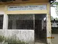 Prakash Nath Public High School
References
- Chanda, Jiban Kumar (2012). "Khaliajuri Upazila". In Sirajul Islam; Miah, Sajahan; Khanam, Mahfuza; Ahmed, Sabbir (eds.). Banglapedia: the National Encyclopedia of Bangladesh (Online ed.). Dhaka, Bangladesh: Banglapedia Trust, Asiatic Society of Bangladesh. ISBN 984-32-0576-6. OCLC 52727562. OL 30677644M. Retrieved 25 October 2023.
- Majumdar, Kodarnath. ময়মনসিংহের ইতিহাস [History of Mymensingh] (in Bengali). p. 15.
- Basu, Nagendranath. Bangla Bishwakosh বাংলা বিশ্বকোষ [Bengali Encyclopedia] (in Bengali).
- Choudhury, Achyut Charan (1917). (in Bengali) (first ed.). Kolkata: Kotha. pp. 252–53 – via Wikisource.
- "Bangladesh Population and Housing Census 2011: Zila Report – Netrakona" (PDF). Table P01 : Household and Population by Sex and Residence, Table P05 : Population by Religion, Age group and Residence, Table P09 : Literacy of Population 7 Years & Above by Religion, Sex and Residence. Bangladesh Bureau of Statistics (BBS), Ministry of Planning, Government of the People’s Republic of Bangladesh. Retrieved 14 December 2018.
- "Population Census Wing, BBS". Archived from the original on 2005-03-27. Retrieved November 10, 2006.
- "District Statistics 2011: Netrokona" (PDF). Bangladesh Bureau of Statistics. Archived from the original (PDF) on 13 November 2014. Retrieved 14 July 2014.
- "Previous Chairmen". Khaliyazuri Ufozela (in Bengali).
Capital: Netrokona | ||
| Upazilas | ||
| Constituencies | ||
| Attractions and sites |
| |
| History | ||
| Inhabited areas | ||
| Rivers | ||
| Educational institutions | ||
| Transport | ||
Headquarters: Mymensingh | ||
| Jamalpur District |  | |
| Mymensingh District | ||
| Netrokona District | ||
| Sherpur District | ||