Madan Upazila
Madan (Bengali: মদন) is an upazila of Netrokona District[1] in the Division of Mymensingh, Bangladesh.
Madan
মদন | |
|---|---|
 Madan Location in Bangladesh | |
| Coordinates: 24°43′N 90°58′E | |
| Country | |
| Division | Mymensingh Division |
| District | Netrokona District |
| Area | |
| • Total | 225.85 km2 (87.20 sq mi) |
| Population (2011) | |
| • Total | 154,479 |
| • Density | 680/km2 (1,800/sq mi) |
| Time zone | UTC+6 (BST) |
| Website | Official Map of Madan |
Geography
Madan is located at 24.7167°N 90.9667°E. It has 21,808 households and total area 225.85 km2. It is bounded by Atpara and Mohanganj upazilas on the north, Itna and Tarail upazilas on the south, Khaliajuri upazila on the east, Kendua upazila on the west.[1]
Demographics
According to 2011 Bangladesh census, Madan had a population of 154,479. Males constituted 49.24% of the population and females 50.34%. Muslims formed 93.33% of the population, Hindus 6.59%, Christians 0.01% and others 0.08%. Madan had a literacy rate of 30.41% for the population 7 years and above.[2]
As of the 1991 Bangladesh census, Madan had a population of 117,613. Males constituted 50.99% of the population, and females 49.01%. This Upazila's eighteen up population was 58,127. Madan had an average literacy rate of 18.7% (7+ years), and the national average of 32.4% literate.[3]
Administration
Madan Thana was formed in 1917 and it was turned into an upazila in 1983.[1]
Madan Upazila is divided into Madan Municipality and eight union parishads: Fatehpur, Gobindasree, Chandgaon, Kaitail, Madan, Maghan, Nayekpur, and Tiasree. The union parishads are subdivided into 84 mauzas and 114 villages.[4]
Madan Municipality is subdivided into 9 wards and 11 mahallas.[4]
Gallery
 Uchitpur Ghat at Madan.
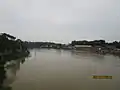 Mogra River from the bridge at Madan Upazila.
References
- Syed Marufuzzaman (2012), "Madan Upazila", in Sirajul Islam and Ahmed A. Jamal (ed.), Banglapedia: National Encyclopedia of Bangladesh (Second ed.), Asiatic Society of Bangladesh
- "Bangladesh Population and Housing Census 2011: Zila Report – Netrakona" (PDF). Table P01 : Household and Population by Sex and Residence, Table P05 : Population by Religion, Age group and Residence, Table P09 : Literacy of Population 7 Years & Above by Religion, Sex and Residence. Bangladesh Bureau of Statistics (BBS), Ministry of Planning, Government of the People’s Republic of Bangladesh. Retrieved 14 December 2018.
- "Population Census Wing, BBS". Archived from the original on 27 March 2005. Retrieved 10 November 2006.
- "District Statistics 2011: Netrokona" (PDF). Bangladesh Bureau of Statistics. Archived from the original (PDF) on 13 November 2014. Retrieved 14 July 2014.
Capital: Netrokona | ||
| Upazilas | ||
| Constituencies | ||
| Attractions and sites |
| |
| History | ||
| Inhabited areas | ||
| Rivers | ||
| Educational institutions | ||
| Transport | ||
Headquarters: Mymensingh | ||
| Jamalpur District | 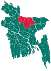 | |
| Mymensingh District | ||
| Netrokona District | ||
| Sherpur District | ||