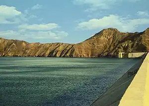
Khuzdar
Khuzdar (Brahui/Balochi: قصدار; Urdu: خضدار, pronounced ['xʊzd̪ɑːɾ]) is the capital city of the Khuzdar District in the central part of the Balochistan province of Pakistan. Khuzdar is the 3rd-largest city of the Balochistan province and the 48th-largest city of Pakistan by population according to the 2017 census. Historically, Khuzdar was the main city and capital of the Jhalawan province of the Khanate of Kalat. From October 1952 to 1955, it became part of the Balochistan States Union. In 1955, Khuzdar became the capital of the newly formed Kalat Division. Currently, it is the largest Brahui-speaking city.[2][3][4]
Khuzdar
| |
|---|---|
City | |
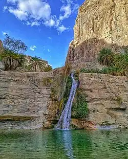 Charoo Waterfall | |
 Khuzdar  Khuzdar | |
| Coordinates: 27°48′N 66°37′E | |
| Country | |
| Province | Balochistan |
| Area | |
| • City | 360 km2 (140 sq mi) |
| Elevation | 1,237 m (4,058 ft) |
| Population | |
| • City | 802,207 |
| • Rank | 48th in Pakistan; 3rd in Balochistan |
| • Density | 2,200/km2 (5,800/sq mi) |
| Time zone | UTC+5 (PST) |
| Postal code | 89100 |
| Calling code | 848 |
Etymology
The name for the city was originally in the Middle Persian language, deriving from the Middle Persian word for silk - "qaz", and "dar" which originates from Arabic meaning "house of" or "seat of"[5] - "Qazdar", meaning "place of silk". After the Islamic conquest of Sindh (which included Khuzdar at the time) that solidified the leadership of the area under the Muslims, the name of the city was changed to "Khuzdar". "Khuz" means to "take firmly" or "retain forever" in Arabic.[6]
History
Under the rule of the Umayyad caliphate, the city was the capital of the Turan province, which was retained administratively from the Sasanian Empire.[7]
Under Abbasid rule a route from Iran through north-west Balochistan connected Qandabil, Kalat, Khuzdar, and Multan. A caravan route connected Khuzdar with Sehwan. After the decline of Arab rule, Sabuktigin, the founder of the Ghaznavid dynasty, conquered Khuzdar.[8]
Khuzdar became the capital of the Brahui kingdom of Makran.[9]
In the early 17th century, it was part of the Jhalawan Kingdom, but it soon fell under the Khanate of Kalat, where it remained until a series of revolts during the reign of Khudadad Khan (1857–1893). By 1896, after Khudadad's death, the authority of Kalat was restored.[10]
Under a treaty with Kalat, the British appointed a political agent at Khuzdar in 1903. British assistance continued until 1947, after which the area was acceded to Pakistan and became a democracy. When the Balochistan States Union became Kalat Division, Khuzdar was established as the divisional headquarters. The divisional administration of Pakistan ended in 2000. Khuzdar was again established as the divisional headquarters in 2009, by the Pakistan People's Party government.[11]
Education
The city has a number of government and private colleges, including the following:
- Balochistan Residential College
- Balochistan University of Engineering and Technology
- Boys Degree College, Khuzdar
- Al Farooq Residential School, Khuzdar
- Divisional Public School and College, Khuzdar
- Girls Degree College, Khuzdar
- Government College of Elementary Education (Women), Khuzdar
- Hamdam College of Education, Khuzdar
- Jhalawan Law College
- Jhalawan Medical College
- Lasbela University of Agriculture, Water and Marine Science, Khuzdar campus
- Pakistan Public School, Khuzdar
- Sardar Bahadur Khan Women's University, Khuzdar sub-campus
- Shaheed Sikander Zarakzai University, Khuzdar
- Sunrise Public School and College, Khuzdar
- Workers Model Higher Secondary School
Geography and climate
Khuzdar is at the apex of a narrow valley at an elevation of 1,237 metres (4,058 ft). Despite this altitude, Khuzdar like most of Balochistan has an arid climate (Köppen BWh) with very low and erratic rainfall. Unlike most parts of the province, the heaviest average rainfall comes from the Asian monsoon in July and August, though this rainfall tends to be very erratic and in many summers there is no significant rain at all.
| Climate data for Khuzdar | |||||||||||||
|---|---|---|---|---|---|---|---|---|---|---|---|---|---|
| Month | Jan | Feb | Mar | Apr | May | Jun | Jul | Aug | Sep | Oct | Nov | Dec | Year |
| Record high °C (°F) | 27.1 (80.8) |
28.4 (83.1) |
33.0 (91.4) |
37.2 (99.0) |
41.7 (107.1) |
43.0 (109.4) |
43.0 (109.4) |
42.0 (107.6) |
40.2 (104.4) |
38.0 (100.4) |
31.2 (88.2) |
28.0 (82.4) |
43.0 (109.4) |
| Average high °C (°F) | 17.0 (62.6) |
18.4 (65.1) |
23.5 (74.3) |
29.9 (85.8) |
35.0 (95.0) |
38.1 (100.6) |
36.2 (97.2) |
35.4 (95.7) |
34.0 (93.2) |
29.9 (85.8) |
24.9 (76.8) |
21.4 (70.5) |
28.6 (83.6) |
| Daily mean °C (°F) | 10.1 (50.2) |
11.7 (53.1) |
17.0 (62.6) |
23.2 (73.8) |
28.1 (82.6) |
31.3 (88.3) |
30.3 (86.5) |
29.3 (84.7) |
27.0 (80.6) |
21.9 (71.4) |
16.7 (62.1) |
11.9 (53.4) |
21.5 (70.8) |
| Average low °C (°F) | 3.2 (37.8) |
5.0 (41.0) |
10.7 (51.3) |
16.5 (61.7) |
21.3 (70.3) |
24.5 (76.1) |
24.3 (75.7) |
23.2 (73.8) |
20.1 (68.2) |
13.9 (57.0) |
8.4 (47.1) |
4.5 (40.1) |
14.6 (58.3) |
| Record low °C (°F) | −8 (18) |
−4.1 (24.6) |
0.6 (33.1) |
8.6 (47.5) |
11.0 (51.8) |
16.0 (60.8) |
17.0 (62.6) |
15.0 (59.0) |
12.8 (55.0) |
5.0 (41.0) |
1.0 (33.8) |
−6.1 (21.0) |
−8 (18) |
| Average rainfall mm (inches) | 16.9 (0.67) |
26.1 (1.03) |
27.7 (1.09) |
12.6 (0.50) |
13.1 (0.52) |
11.1 (0.44) |
47.7 (1.88) |
64.5 (2.54) |
6.4 (0.25) |
5.0 (0.20) |
5.7 (0.22) |
15.6 (0.61) |
252.4 (9.95) |
| Source: NOAA (1971–1990)[12] | |||||||||||||
References
- "PAKISTAN: Provinces and Major Cities". PAKISTAN: Provinces and Major Cities. citypopulation.de. Retrieved 4 May 2020.
- "Province-wise" (PDF).
- "Division-wise" (PDF).
- "Tehsil-wise" (PDF).
- "Dar".
- "HERITAGE: THE RUINED FORTS OF KHUZDAR".
- "History of District".
- "HERITAGE: THE RUINED FORTS OF KHUZDAR".
- Risley, Herbert Hope (1903) Census of India, 1901. Volume I. India. Ethnographic appendices, being the data upon which the caste chapter of the Report is based Office of the Superintendent of Government Printing, Calcutta, page 66, OCLC 2196225
- Hughes-Buller, R. (ed.) (1908) Imperial gazetteer of India: Provincial Series: Baluchistan Office of the Superintendent of Government Printing, Calcutta, pages 16–17
- "District-Khuzdar".
- "Khuzdar Climate Normals 1971–1990". National Oceanic and Atmospheric Administration. Retrieved January 17, 2013.
Largest cities or towns in Balochistan, Pakistan | |||||||||||||||||||||||||||||||||||||||||||||||||||||||||
|---|---|---|---|---|---|---|---|---|---|---|---|---|---|---|---|---|---|---|---|---|---|---|---|---|---|---|---|---|---|---|---|---|---|---|---|---|---|---|---|---|---|---|---|---|---|---|---|---|---|---|---|---|---|---|---|---|---|
| |||||||||||||||||||||||||||||||||||||||||||||||||||||||||